
SLAM method applied to a multi-lens combination panoramic camera

A panoramic camera, multi-lens technology, applied in computer parts, character and pattern recognition, image analysis, etc., can solve problems such as inability to achieve measurement functions

Active Publication Date: 2019-03-22
WUHAN UNIV
View PDF9 Cites 43 Cited by
  • Summary
  • Abstract
  • Description
  • Claims
  • Application Information

AI Technical Summary

Problems solved by technology

Panoramic imaging devices mounted on mobile mapping systems or ordinary cars are usually only used for street view collection, such as the street view images of Google and Baidu, which cannot realize the measurement function; geometric positioning and SLAM based on panoramic vision have also had a small number of applications. research, however, a complete, automated solution is currently lacking

Method used


Image

  • SLAM method applied to a multi-lens combination panoramic camera
  • SLAM method applied to a multi-lens combination panoramic camera
  • SLAM method applied to a multi-lens combination panoramic camera

Examples


Embodiment Construction

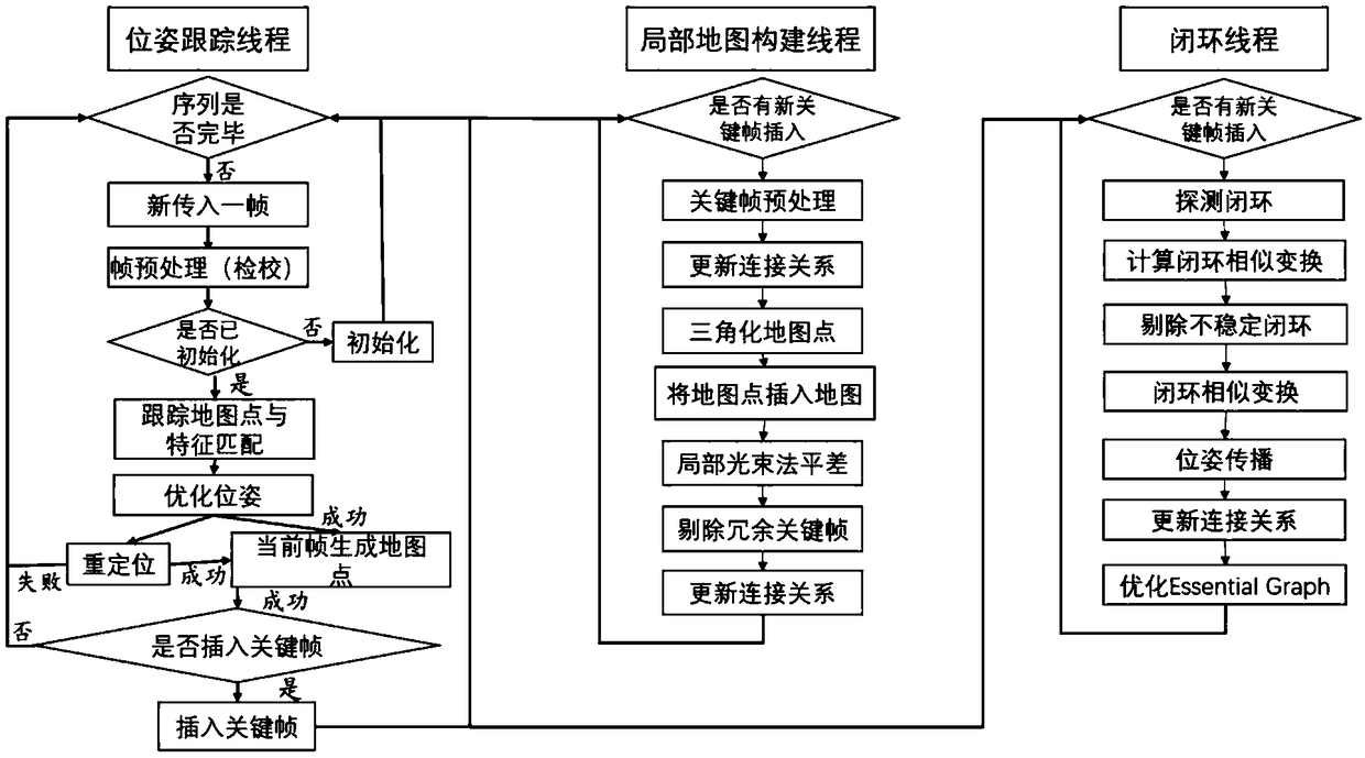
[0069] The concrete operation process of the inventive method is as attached figure 1 As shown, the system consists of three parallel threads, which are respectively responsible for panoramic image pose tracking, sparse map construction and closed-loop correction. The pose tracking thread mainly completes system initialization, feature extraction, matching and projection on the panoramic image, pose solution optimization, and key frame selection; the sparse map construction thread is mainly responsible for establishing sparse map points based on the initial pose and matching points, The pose and map points are locally optimized, and wrong map points and redundant key frames are eliminated; the closed-loop correction thread is mainly responsible for detecting whether the motion of the camera has returned to the previous position (that is, closed loop), and adding closed-loop constraints to correct the pose And global pose and map point optimization (that is, global beam adjustm...


PUM


Abstract

The invention provides a SLAM method applied to a multi-lens combination panoramic camera, which well realizes the automatic positioning and map construction functions of a vehicle-mounted multi-lenscombination panoramic camera, and achieves a high positioning accuracy of 0.1 m level without resorting to an expensive GPS / IMU integrated navigation system. The method firstly performs camera calibration on a multi-lens combination device, and then establishes a parallel three-thread, wherein the pose tracking thread mainly completes system initialization, feature extraction on a panoramic image,matching and projection, pose solution optimization and selection of key frames; The sparse map construction thread is mainly responsible for establishing sparse map points according to the initial posture and matching points, optimizing the camera posture and map points locally, and eliminating the wrong map points and redundant key frames. The closed-loop correction thread is mainly responsiblefor detecting whether the motion of the camera has returned to the previous position (i.e. Closed-loop), adding closed-loop constraints to correct the posture and global posture and map point optimization (i.e. Global beam adjustment).

Description

technical field [0001] The invention relates to a SLAM method applied to a multi-lens combined panoramic camera, which belongs to the fields of photogrammetry and remote sensing, computer vision, robots and the like. Background technique [0002] With the development of sensor, automation and platform technology, using optical or distance sensors placed on the platform, the intelligent system that realizes self-localization and environmental perception at the same time has become a new research direction in photogrammetry, computer vision and robotics; and in mobile mapping Systems, unmanned vehicles, deep space exploration of Mars and the moon, drone reconnaissance, indoor navigation and other fields play a key role. If the optical sensor is used as the main source of information acquisition, this system is usually called vision-based automatic localization and map construction (Simultaneous Localization And Mapping, SLAM). Mainstream visual SLAM systems have two classific...

Claims


Application Information

Patent Timeline
Patent Type & Authority Applications(China)
IPC IPC(8): G06T7/73G06T7/33G06T3/00G06K9/00
CPCG06T7/337G06T7/73G06V20/48G06T3/047
Inventor 季顺平秦梓杰
Owner WUHAN UNIV
Learn More