Supercharge Your Innovation With Domain-Expert AI Agents!

Virtual point fusion observation generation method for relative positioning of satellite navigation

A relative positioning and satellite navigation technology, applied in the field of satellite navigation relative positioning, can solve the problems of increasing the number of carrier phase integer ambiguity solutions, increasing the communication link capacity requirements, affecting the real-time performance of relative positioning, etc. Improve speed and ensure real-time effect

Inactive Publication Date: 2019-03-29
NO 20 RES INST OF CHINA ELECTRONICS TECH GRP
View PDF8 Cites 3 Cited by
  • Summary
  • Abstract
  • Description
  • Claims
  • Application Information

AI Technical Summary

Problems solved by technology

[0004] The above two methods can effectively guarantee the integrity performance of the relative system by introducing multi-node satellite navigation observation information, but they need to simultaneously broadcast the observation information of multiple reference receivers to the mobile station for relative positioning calculation, which not only greatly increases the communication chain. Road capacity requirements, and the mobile station needs to process multi-node satellite navigation information at the same time, which increases the number of carrier phase ambiguity solutions, and the resource consumption of the mobile station equipment is too large, which affects the real-time performance of relative positioning

Method used


Image

  • Virtual point fusion observation generation method for relative positioning of satellite navigation
  • Virtual point fusion observation generation method for relative positioning of satellite navigation
  • Virtual point fusion observation generation method for relative positioning of satellite navigation

Examples


Embodiment Construction

[0027] The present invention will be further described below in conjunction with the accompanying drawings and embodiments, and the present invention includes but not limited to the following embodiments.

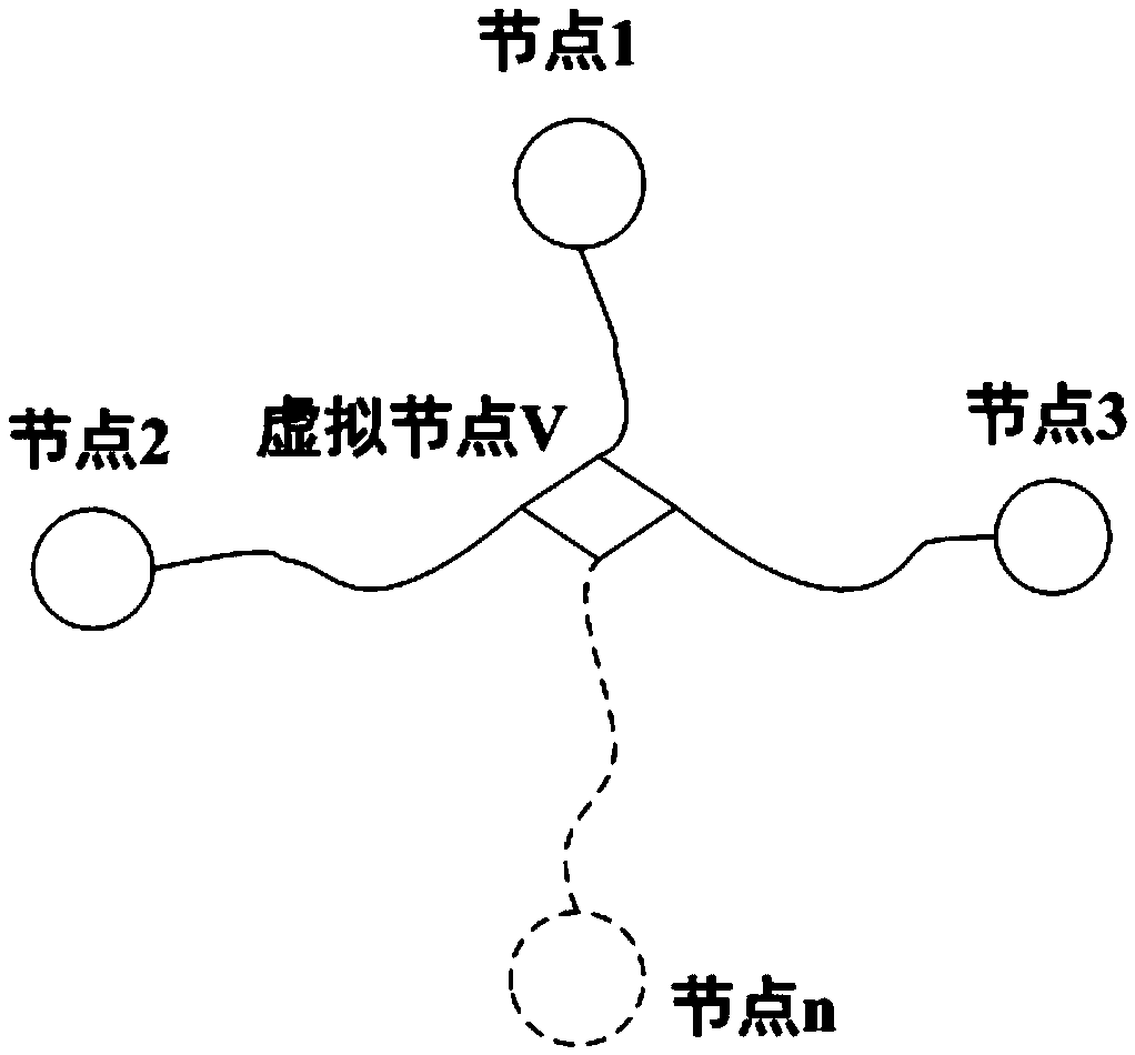
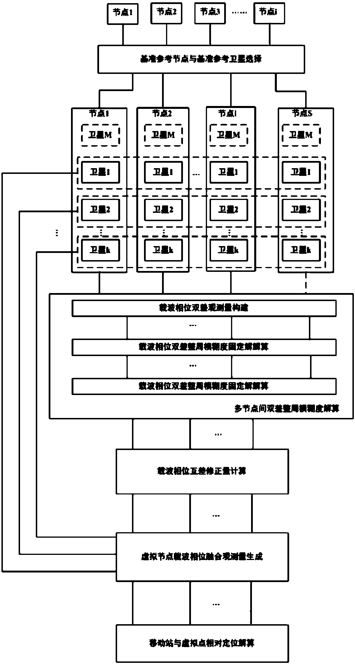
[0028] The overall block diagram of the method for generating virtual point fusion observations provided by the present invention is as follows: figure 1 shown. The multi-nodes include node 1, node 2, node 3, ... node n (n=1, 2, 3 ... N), a total of N nodes. This method fuses the reference receiver observation data of N nodes into the observation data on the virtual point V.

[0029] The present invention is divided into five steps, which are step 1: selection of reference reference nodes and reference satellites; step 2: double-difference integer ambiguity resolution; step 3: calculation of carrier phase mutual difference correction; step 4: virtual node Generation of carrier phase fusion observations; Step 5: Relative positioning calculation between the mobile station a...


PUM


Abstract

The invention provides a virtual point fusion observation generation method for relative positioning of satellite navigation. The method comprises the following steps of: calculating double-differencewhole-cycle ambiguity between the other nodes excepting a S node and the node S; calculating carrier phase difference correction between satellite k and satellite M to obtain the virtual node V carrier phase fusion observation; and transmitting the virtual node carrier phase fusion observation to a mobile station, and combining satellite navigation observation information received by the mobile station to perform carrier phase differential relative positioning solution by the mobile station. The method reduces the data amount of the transmission observation information required for differential relative positioning on the premise of ensuring the integrity of the relative positioning system, and reduces the communication link capacity requirement. The method can effectively reduce the number of solutions of the carrier phase ambiguity of the mobile station, reduce the computing resource consumption of the mobile station device, improve the carrier phase difference operation speed of the mobile station, and ensure instantaneity of the relative positioning operation.

Description

technical field [0001] The invention belongs to the field of satellite navigation relative positioning, and relates to a method for merging multi-node data observations into single-node observations for relative positioning in a satellite navigation relative positioning system. Background technique [0002] Satellite navigation relative positioning system is a system based on the principle of satellite navigation differential relative positioning technology, which can be used for relative positioning applications such as precision landing and aerial refueling. These applications require not only high precision relative position but also high integrity performance of the solved relative position. In order to ensure the integrity performance of the satellite navigation relative positioning system, the reference station is usually equipped with multiple satellite navigation receivers in these applications, and the integrity monitoring is carried out by using the multi-node sate...

Claims


Application Information

Patent Timeline
IPC IPC(8): G01S19/42G01S19/29G01S19/41
CPCG01S19/29G01S19/41G01S19/42
Inventor 原彬王晓旺蒋军冯泽林毅
Owner NO 20 RES INST OF CHINA ELECTRONICS TECH GRP
Features
  • R&D
  • Intellectual Property
  • Life Sciences
  • Materials
  • Tech Scout
  • Unparalleled Data Quality
  • Higher Quality Content
  • 60% Fewer Hallucinations
Learn More