MF method for automatic fusion of multi-source heterogeneous bathymetric data to construct high-resolution dbm

A multi-source heterogeneous, high-resolution technology, applied in structured data retrieval, structured data browsing, visual data mining, etc.

Active Publication Date: 2021-07-06
SECOND INST OF OCEANOGRAPHY MNR
View PDF5 Cites 0 Cited by
  • Summary
  • Abstract
  • Description
  • Claims
  • Application Information

AI Technical Summary

Problems solved by technology

[0005] The invention discloses an MF (Merge-Fusion) method for automatically merging multi-source heterogeneous water depth data to construct a high-resolution DBM, aiming to solve the problem of interpolation accuracy in data blank areas and sparse areas in the process of multi-source data fusion

Method used


Image

  • MF method for automatic fusion of multi-source heterogeneous bathymetric data to construct high-resolution dbm
  • MF method for automatic fusion of multi-source heterogeneous bathymetric data to construct high-resolution dbm
  • MF method for automatic fusion of multi-source heterogeneous bathymetric data to construct high-resolution dbm

Examples


Embodiment 1

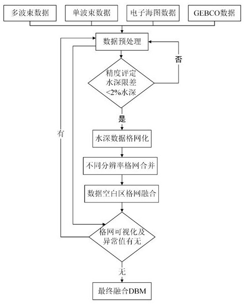
[0147] In order to verify the effectiveness and correctness of "an MF method that automatically fuses multi-source heterogeneous water depth data to construct high-resolution DBM", a typical area of ​​multi-source data is selected for experiment and comparison. The specific process is as follows:

[0148] 1) Data preprocessing: process the multi-source water depth data into a discrete data format, and unify the projection method and depth datum to UTM projection and mean sea level, respectively. Next, the abnormal points of the multi-source water depth data are cleaned up, and then re-exported into a discrete format to form a multi-source water depth database.

[0149] 2) Accuracy assessment of multi-source data: discrete electronic charts, single-beam sounding points and GEBCO data are compared with multi-beam data with a resolution of 100m. The three are combined with multi-beams one by one, and the combination criterion is that the distance between the two is less than 50m....


PUM


Abstract

The invention discloses an MF method for automatically fusing multi-source heterogeneous water depth data to construct a high-resolution DBM. This method organically integrates multi-beam, single-beam, electronic chart data and global ocean topography data through the technical process of merging-fusion, so as to solve the problem of complex sources of global bathymetric data, large differences in accuracy, and difficulty in integrating and constructing high-level data. Problems with precision digital bathymetry models. The method includes the following steps: preprocessing data, evaluating accuracy, gridding, grid merging, fusion, visual comparison analysis and cleaning abnormal points, and completing the fusion of multi-source water depth data. The fused DBM can better reflect fine topographic feature information, while retaining high-resolution topographic details, it fills in data gaps, and can be extended and applied to the management and utilization of multi-source heterogeneous bathymetric data. , marine geographic information system, seabed topography and landform mapping, marine scientific research and other aspects have important practical application value.

Description

technical field [0001] The invention relates to the technical fields of marine surveying and mapping, seabed topography and landform mapping, computer graphics, marine geographic information system and marine science. Background technique [0002] Digital bathymetric model (Digital Bathymetric Model, DBM) is the basis for almost all modern marine activities. High-resolution DBM can be used not only for the construction of charts, but also for the analysis of landform characteristics and causes, seabed structure, marine resources, etc. Research. However, since more than 80% of the global sea area is still not detected by multi-beam, historical bathymetric data still have to be used when constructing deep-sea large-scale DBM. At present, ocean bathymetry data are mainly collected independently for different purposes, resulting in many differences in sources and resolutions. The multi-source complexity of global ocean bathymetric data is not conducive to the construction of h...

Claims


Application Information

Patent Timeline
Patent Type & Authority Patents(China)
IPC IPC(8): G06T17/30G06T3/40G06F16/26
CPCG06T3/4007G06T17/30
Inventor 刘洋吴自银赵荻能周洁琼尚继宏王明伟朱超鲁号号
Owner SECOND INST OF OCEANOGRAPHY MNR
Why Eureka
Try Eureka