
Radar terrain masking analysis and display method

A display method and technology of display mode, applied in the direction of reflection/re-radiation of radio waves, utilization of re-radiation, measurement devices, etc., can solve the problems of low accuracy of human and material resources, cost a lot of time, etc., achieve accurate results, avoid loading and calculation. , the effect of improving computational efficiency

Active Publication Date: 2019-04-05
CHINA ELECTRONIC TECH GRP CORP NO 38 RES INST
View PDF3 Cites 10 Cited by
  • Summary
  • Abstract
  • Description
  • Claims
  • Application Information

AI Technical Summary

Problems solved by technology

Traditional methods have the disadvantages of spending a lot of time on surveying, taking up a lot of manpower and material resources, and low accuracy.

Method used


Image

  • Radar terrain masking analysis and display method
  • Radar terrain masking analysis and display method
  • Radar terrain masking analysis and display method

Examples


Embodiment Construction

[0046] The embodiments of the present invention are described in detail below. This embodiment is implemented on the premise of the technical solution of the present invention, and detailed implementation methods and specific operating procedures are provided, but the protection scope of the present invention is not limited to the following implementation example.

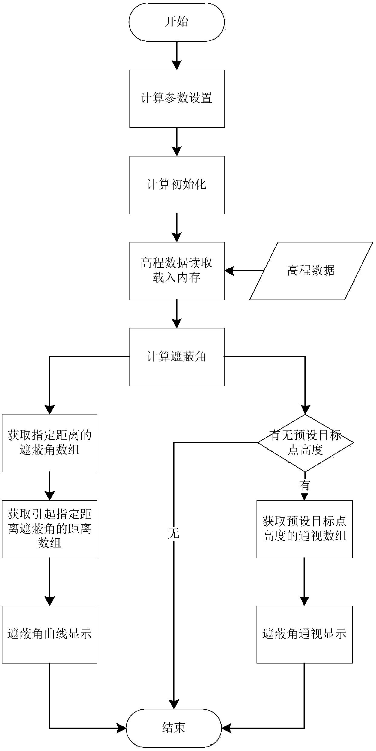
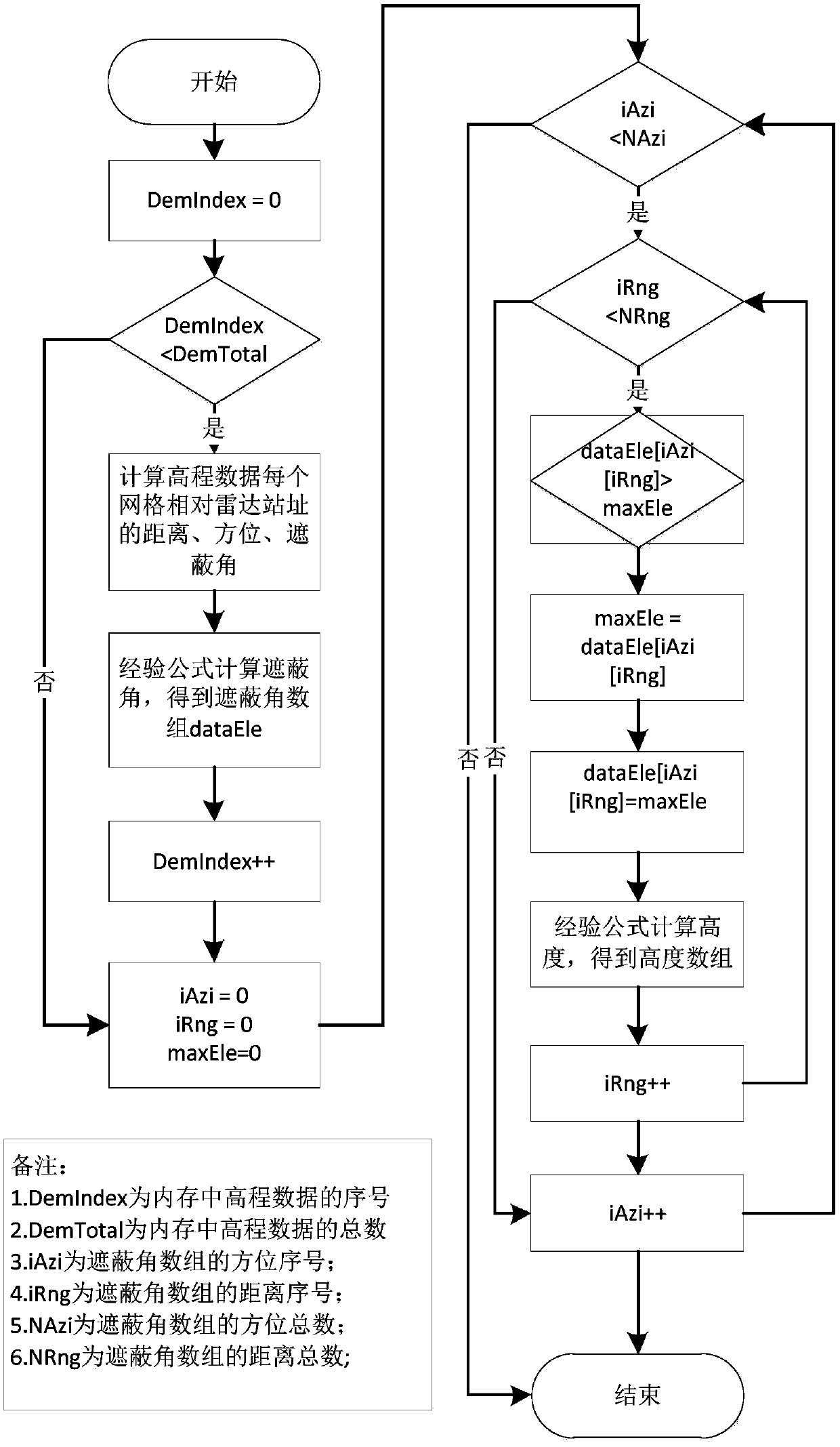
[0047] Such as figure 1 As shown, the workflow of the intelligence radar shading angle calculation and display method in this embodiment includes the following processing:

[0048] 1. The user sets the calculation parameters according to the needs, including the radar site longitude (degree) RadarLat, latitude (degree) RadarLon, height (meter) RadarAlt, the latitude and longitude range to be calculated, and the maximum detection distance R max , azimuth accuracy (degrees) P Azi , distance accuracy (m)P Rng ;

[0049] 2. According to the set calculation parameters, initialize the target data of the shading angle...


PUM


Abstract

The invention discloses a radar terrain masking analysis and display method which comprises the steps of: according to a longitude, a latitude and a height of a radar site, which are set by a user, and a longitude and latitude range which needs to be calculated, carrying out loading on elevation data by taking the radar site as the center and taking the longitude and latitude range as a radius; according to a radar detection minimum elevation angle, a maximum detection distance, azimuth accuracy and distance accuracy which are set by the user, initializing radar masking data; according to theloaded elevation data, analyzing a radar terrain masking condition; and constructing a multi-dimension display mode by using the calculated radar terrain masking data. A space is partitioned in two dimensions of a distance and an azimuth, and terrain masking information of each unit is respectively analyzed; a calculation method of a masking angle adopts an empirical formula considering various factors such as atmospheric refraction and the like; on the basis of calculating the masking angle, a visibility range of a radar for a fixed height target is calculated; display of the visibility rangeand display of a masking angle curve provide an approach for multi-azimuth multi-angle observation and analysis of the radar terrain masking condition.

Description

technical field [0001] The invention relates to a method for displaying radar topography, in particular to a method for analyzing and displaying radar topography shading. Background technique [0002] In radar analysis and research, position selection is a very important part. The detection power of radar is not only determined by the performance of the radar itself, but also depends on the terrain around the radar position. [0003] Traditional radar position selection is generally based on field surveys, directly combined with topography and landforms, and combined with technical indicators for position selection. The traditional method has the shortcomings of spending a lot of time on surveying, taking up a lot of manpower and material resources, and low accuracy. Therefore, it is an urgent problem to be solved when quickly selecting a suitable radar position. [0004] The radar terrain shading analysis and display method based on the digital elevation model (DEM) over...

Claims


Application Information

Patent Timeline
Patent Type & Authority Applications(China)
IPC IPC(8): G01S13/42G01S13/88
CPCG01S13/42G01S13/885
Inventor 周慧德李帅钮俊清王顺利安良
Owner CHINA ELECTRONIC TECH GRP CORP NO 38 RES INST
Learn More