
Multi-sensor integrated navigation method and system for downhole vehicle

An integrated navigation system and multi-sensor technology, which is applied in the field of multi-sensor integrated navigation methods and systems for underground vehicles, can solve the problems of inability to locate and indistinguishable distances, and achieve the effects of high data fusion accuracy and strong fault tolerance

Pending Publication Date: 2019-04-12
BEIDOU TIANDI CO LTD
View PDF5 Cites 4 Cited by
  • Summary
  • Abstract
  • Description
  • Claims
  • Application Information

AI Technical Summary

Problems solved by technology

But the current Bluetooth positioning is actually a kind of regional positioning, which can only achieve a positioning accuracy of 5-10m, and the distance in the signal area cannot be distinguished, and when the distance between two stations is too far and there is no signal in the middle, positioning cannot be performed

Method used


Image

  • Multi-sensor integrated navigation method and system for downhole vehicle
  • Multi-sensor integrated navigation method and system for downhole vehicle
  • Multi-sensor integrated navigation method and system for downhole vehicle

Examples


Embodiment Construction

[0055] The principles and features of the present invention are described below in conjunction with the accompanying drawings, and the examples given are only used to explain the present invention, and are not intended to limit the scope of the present invention.

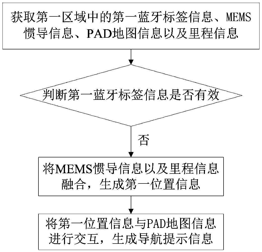
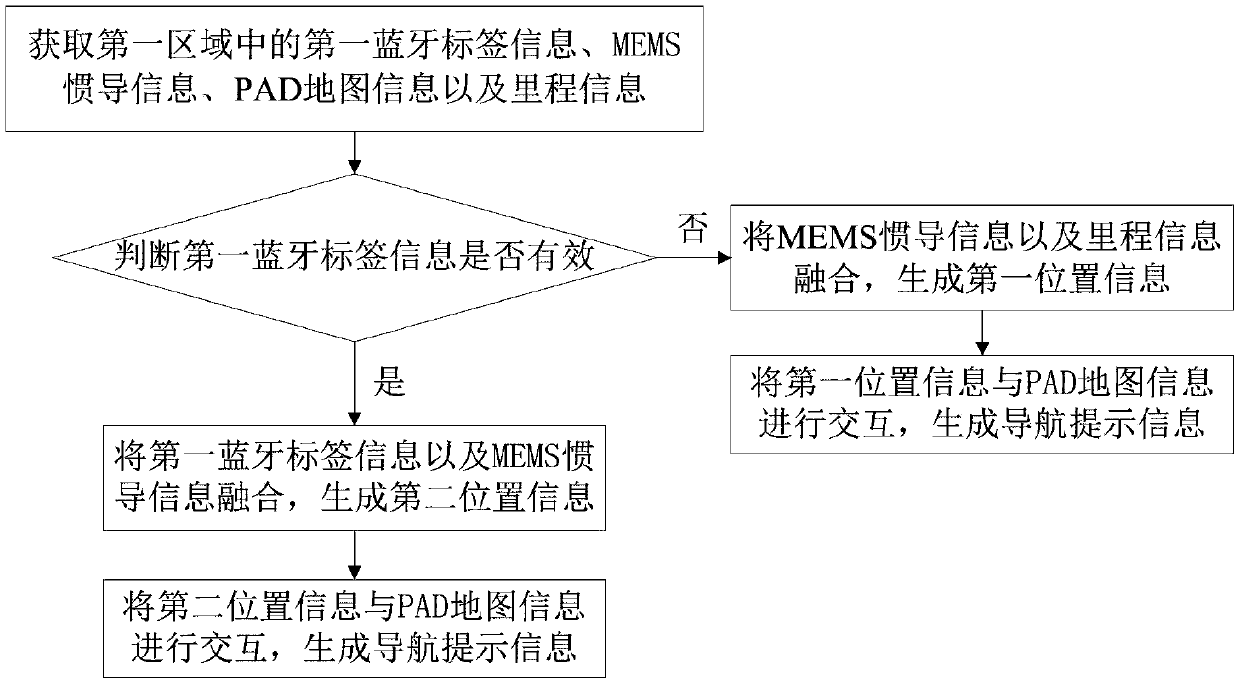
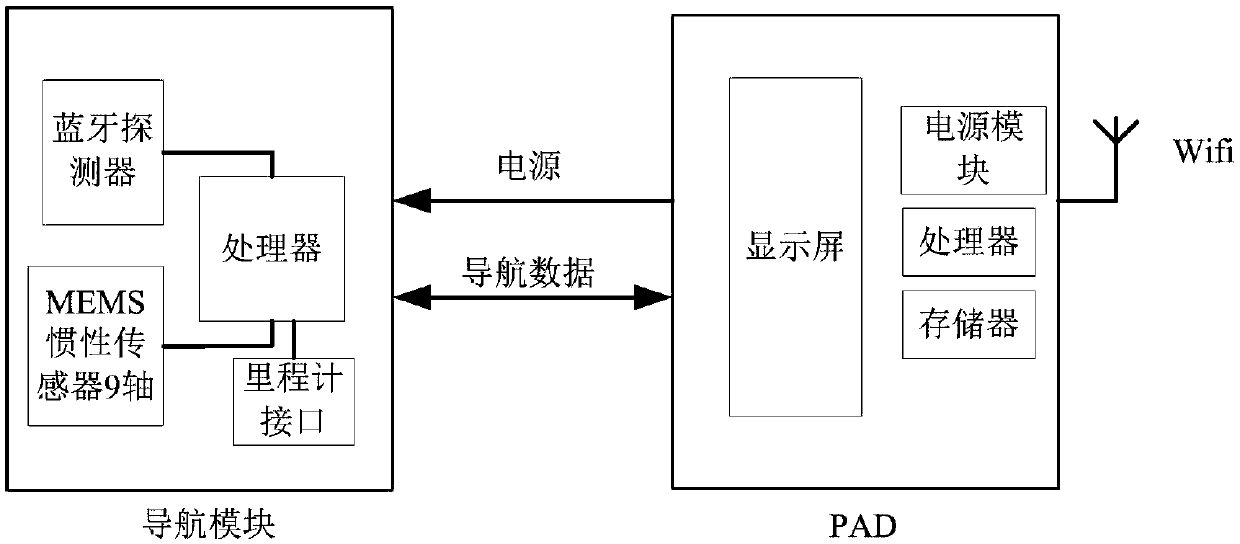
[0056] Such as Figure 1 to Figure 6 as shown, figure 1 It is one of the schematic flowcharts of the navigation method provided by the embodiment of the present invention. figure 2 The second schematic flow diagram of the navigation method provided by the embodiment of the present invention. image 3 A schematic structural diagram of a navigation system provided by an embodiment of the present invention. Figure 4 It is one of the principle schematic diagrams of the navigation method provided by the embodiment of the present invention. Figure 5 The third schematic flow chart of the navigation method provided by the embodiment of the present invention. Figure 6 The second schematic diagram of the navigation m...


PUM


Abstract

The invention provides a multi-sensor integrated navigation method for a downhole vehicle, which comprises the following steps: acquiring first Bluetooth tag information, MEMS inertial navigation information, PAD map information and mileage information in a first area; determining whether the first Bluetooth tag information is valid; if not, fusing the MEMS inertial navigation information and themileage information to generate first position information; and interacting the first position information with the PAD map information to generate navigation prompt information. The Bluetooth / MEMS inertial navigation system / odometer integrated navigation is used to provide position and velocity information for the vehicle, through information fusion of the Bluetooth tag information, the MEMS inertial navigation information and the mileage information, navigation information is provided for the vehicle, which can obtain positioning and navigation accuracy far superior to that of a single sensor. The multi-sensor integrated navigation method for the downhole vehicle solves the problem that the distance in the signal area is indistinguishable, and when the distance between the two stations is too long and there is no signal in the middle, the positioning can not be carried out.

Description

technical field [0001] The invention relates to the technical field of navigation, in particular to a multi-sensor integrated navigation method and system for an underground vehicle. Background technique [0002] The vehicle positioning technology based on Bluetooth 4.0 is based on the latest near-field wireless communication protocol Bluetooth 4.0 protocol, which is low-cost, easy to deploy, extremely low power consumption and high real-time performance when applied in underground coal mines. However, the current Bluetooth positioning is actually a kind of regional positioning, which can only achieve a positioning accuracy of 5-10m. The distance in the signal area cannot be distinguished, and when the distance between two stations is too far and there is no signal in the middle, positioning cannot be performed. Contents of the invention [0003] The technical problem to be solved by the present invention is to provide a multi-sensor integrated navigation method and system...

Claims


Application Information

Patent Timeline
IPC IPC(8): G01C21/20
CPCG01C21/20
Inventor 张元刚彭继国张波侯双双李国娟王斌张文波刘坤
Owner BEIDOU TIANDI CO LTD
Learn More