Flight precisely approaching and landing method and system

A precise approach technology, applied in traffic control system, control/adjustment system, aircraft automatic landing auxiliary device, etc., can solve problems such as unable to effectively meet the three types of blind landing standards, unable to take off and land normally, and national economic losses, etc. Improve positioning and navigation accuracy, high-precision virtual simulation, and improve safety

Active Publication Date: 2019-04-12
BEIJING SATELLITE INFORMATION ENG RES INST
View PDF13 Cites 4 Cited by
  • Summary
  • Abstract
  • Description
  • Claims
  • Application Information

AI Technical Summary

Problems solved by technology

Moreover, due to weather visibility problems, this system is also crucial to the economy and safety of flight transportation. The existing instrument landing system has alleviated the above problems to a certain extent, but it still cannot effectively meet the three categories of civil aviation organizations. blind drop standard
[0003] In recent years, whenever heavy fog or smog comes, due to the problem of low visibility, it is impossible to take off and land normally, which often leads to large-scale flight delays. Related reports are common and have caused huge losses to the national economy. So far, there has been no There are effective ways or methods to solve the problem of aircraft approach and landing in bad weather

Method used


Image

  • Flight precisely approaching and landing method and system
  • Flight precisely approaching and landing method and system
  • Flight precisely approaching and landing method and system

Examples


Embodiment Construction

[0029] Hereinafter, the present invention will be described in detail based on the drawings.

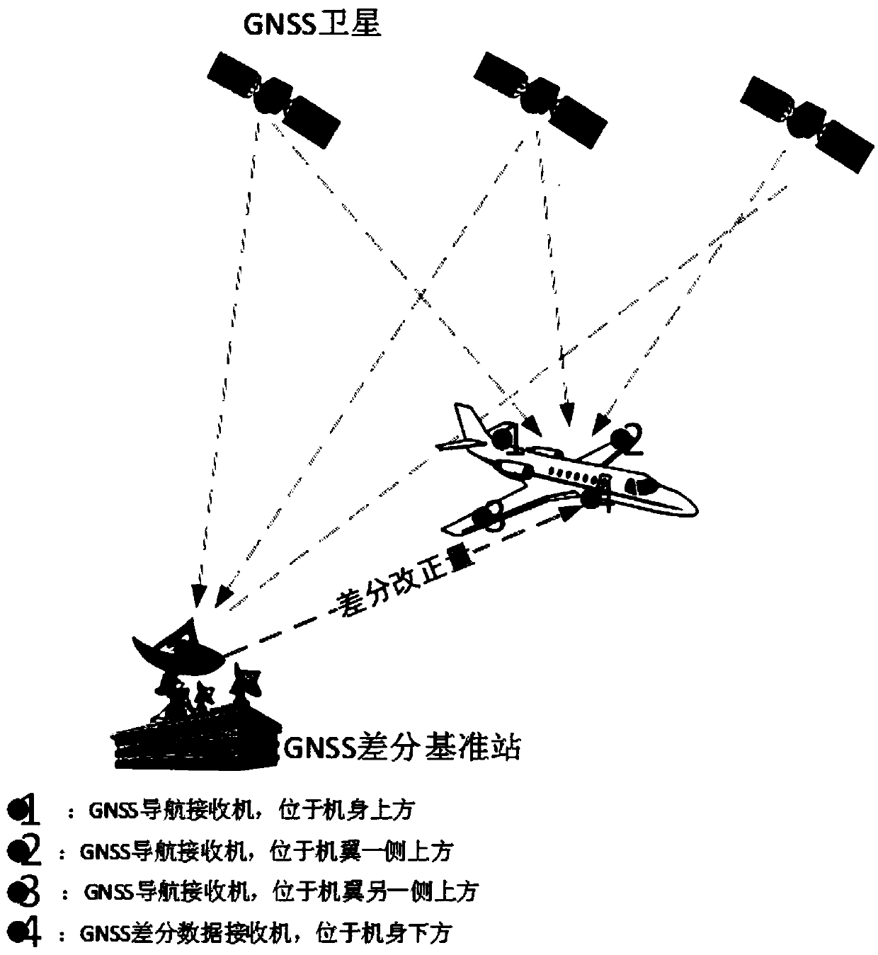
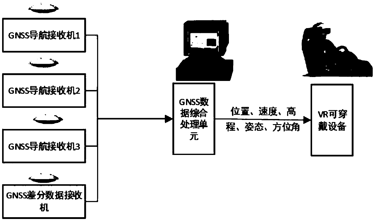
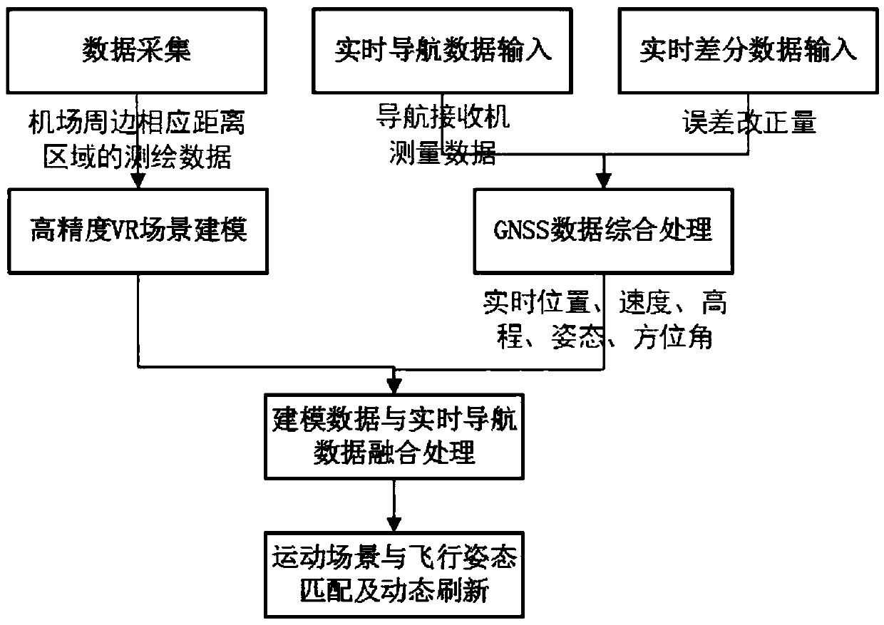
[0030] Such as figure 1 As shown, the present invention has designed a kind of flight precision approach and landing system, and this system mainly includes: several airborne GNSS navigation receivers and a differential data receiver installed on the aircraft, data acquisition equipment, GNSS differential reference station , data processing unit, VR equipment, flight control unit.

[0031] Specifically, the data collection equipment is used to conduct 360-degree surveying, mapping and shooting of the surrounding area of ​​the airport and even the 3D scene of the entire city by using unmanned aerial vehicles or remote sensing satellites for surveying, mapping and shooting, and to construct a three-dimensional virtual reality of VR equipment accordingly. real scene;

[0032] The GNSS differential reference station is set in the area where the airport is located to obtain real-time di...


PUM


Abstract

The invention provides a flight precisely approaching and landing method and system. The flight precisely approaching and landing method comprises the steps that mapping and photographing in airport peripheral areas are carried out, and a three-dimensional virtual reality scene of VR equipment is established; a GNSS difference base station sends differential data to a differential data receiver onan aircraft through a broadcast mode in real time; an airborne GNSS navigation receiver obtains real-time positioning navigation data and differential data real-time summary received by a same differential data receiver, real-time position, elevation, flight speed and posture orientation of the aircraft are calculated and integrated into the established three-dimensional virtual reality scene ofthe VR equipment for scene matching; and in the process of aircraft approaching, the elevation, the flight speed and the posture orientation of the aircraft are observed and adjusted in real time to complete precisely approaching and safely landing of the aircraft. According to the flight precisely approaching and landing method, precisely approaching and landing of the aircraft under any visibility conditions can be realized, accurate measurement and control are achieved, and instrument landing system (ILS) CAT III of a civil aviation organization is completed.

Description

technical field [0001] The invention belongs to the technical field of air transportation management and control, and relates to a flight precision approach and landing method and system. Background technique [0002] The approach and landing process of the aircraft is the most difficult and most critical part of the entire flight process. It requires relatively high weather conditions and the comprehensive technical level of the pilot. Modern commercial air transportation is mainly carried out by large passenger aircraft. Large passenger aircraft are mainly reflected in the large tonnage, high speed, and heavy safety responsibility. Therefore, it is necessary to have a safe and feasible auxiliary landing system to reduce the pilot's operating load and improve flight safety. Moreover, due to weather visibility problems, this system is also crucial to the economy and safety of flight transportation. The existing instrument landing system has alleviated the above problems to a...

Claims


Application Information

Patent Timeline
Patent Type & Authority Applications(China)
IPC IPC(8): G05D1/10G08G5/02
CPCG05D1/101G08G5/025
Inventor 席超田维苏旭阳袁迎慧刘江春杨博时立锋
Owner BEIJING SATELLITE INFORMATION ENG RES INST
Why Eureka
Try Eureka