Composite positioning system for deep sea mining vehicle and positioning method thereof

A composite positioning and deep-sea mining technology, which is applied in the direction of radio wave measurement system, sound wave re-radiation, measurement device, etc., can solve the problem of inertial navigation system error accumulation, etc., achieve small positioning error, overcome the distance between accumulated error and sonar positioning system Blurred, low-power effects

Inactive Publication Date: 2019-04-19
JIANGSU UNIV OF SCI & TECH +1
View PDF20 Cites 6 Cited by
  • Summary
  • Abstract
  • Description
  • Claims
  • Application Information

AI Technical Summary

Problems solved by technology

Due to the lack of a reference system during work, the inertial navigation system is prone to error accumulation

Method used


Image

  • Composite positioning system for deep sea mining vehicle and positioning method thereof
  • Composite positioning system for deep sea mining vehicle and positioning method thereof
  • Composite positioning system for deep sea mining vehicle and positioning method thereof

Examples


Embodiment

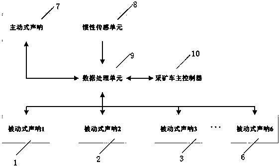
[0028] In this embodiment, the deep-sea mining vehicle composite positioning system, such as figure 1 As shown, it includes active sonar 7, passive sonar 1, passive sonar 2, passive sonar 3, passive sonar 4, passive sonar 5, passive sonar 6, inertial sensing unit 8, data processing unit 9 and mining vehicle main controller 10.

[0029] Active sonar 7, inertial sensing unit 8, data processing unit 9 and mining vehicle main controller 10 are fixedly installed on the mining vehicle, passive sonar 1, passive sonar 2, passive sonar 3, passive sonar 4, passive sonar 5 and passive sonar 6 fixed in mining area water.

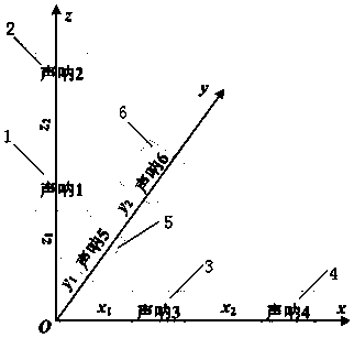
[0030] The inertial sensing unit 8 is composed of a three-axis acceleration sensing module, which collects the acceleration of the mining vehicle in the space coordinate system X, Y, and Z axes in real time through the three-axis acceleration sensing module, and then obtains the acceleration of the mining vehicle on the three coordinate axes through the integral operati...


PUM


Abstract

The invention relates to a composite positioning system for a deep sea mining vehicle and a positioning method thereof. The composite positioning system comprises an active sonar, a passive sonar, aninertia sensing unit, a data processing unit and a mining vehicle main controller, wherein the active sonar, the inertia sensing unit, the data processing unit and the mining vehicle main controller are fixedly installed on a mining vehicle, and the passive sonar is fixed in water of a mining area; the inertia sensing unit is composed of a three-axis acceleration sensing module, accelerations of the mining vehicle in the X axis, the Y axis and the Z axis of a space coordinate system are collected in real time through the three-axis acceleration sensing module, and then the real-time position of the mining vehicle on the three coordinate axes are obtained through integral operation. The method has the advantages that the position of a mining vehicle is obtained in real time through the inertial navigation positioning method, the sonar positioning system is used for calibrating the position of the mining vehicle at intervals of a certain time period, and the problem that the inertial navigation system accumulates errors, and the distance between the sonar positioning system and the inertial navigation system is fuzzy is solved.

Description

technical field [0001] The invention belongs to the field of positioning of underwater mobile equipment, and in particular relates to a composite positioning system and a positioning method for a deep-sea mining vehicle. Background technique [0002] Due to the high attenuation rate of electromagnetic waves in water, they cannot be used as a signal source for detection. The commonly used signals such as GPS, WiFi, and radar on the ground are difficult to be widely used in the deep sea. Therefore, the detection of man-made objects under the water surface by sound waves has become the most widely used method . Sonar is an electronic device that uses the propagation characteristics of sound waves under water to complete underwater detection and communication tasks through electro-acoustic conversion and information processing. It is widely used in detection, positioning, tracking and navigation. According to the working principle of sonar, it can be divided into active sonar a...

Claims


Application Information

Patent Timeline
Patent Type & Authority Applications(China)
IPC IPC(8): G01C21/16G01S15/02
CPCG01C21/165G01S15/86
Inventor 许静卢道华郭浩汤雁冰吴百公刘刚
Owner JIANGSU UNIV OF SCI & TECH
Why Eureka
Try Eureka