Air-space-ground integrated measurement and control method for tailings reservoir risk

A measurement and control method, space-space technology, applied in the direction of measuring devices, instruments, alarms, etc., can solve the problems of high cost, time-consuming, difficult to reach the detection location, etc., and achieve the effect of improving efficiency

Inactive Publication Date: 2019-04-26
四川省安全科学技术研究院
View PDF6 Cites 13 Cited by
  • Summary
  • Abstract
  • Description
  • Claims
  • Application Information

AI Technical Summary

Problems solved by technology

Remote sensing satellite images have the advantages of wide range, time-space continuity, periodicity, easy acquisition and low cost, but only image data can be obtained, the resolution is limited, and detailed data for analysis is lacking; 3D lasers can collec

Method used


Image

  • Air-space-ground integrated measurement and control method for tailings reservoir risk
  • Air-space-ground integrated measurement and control method for tailings reservoir risk
  • Air-space-ground integrated measurement and control method for tailings reservoir risk

Examples


Embodiment 1

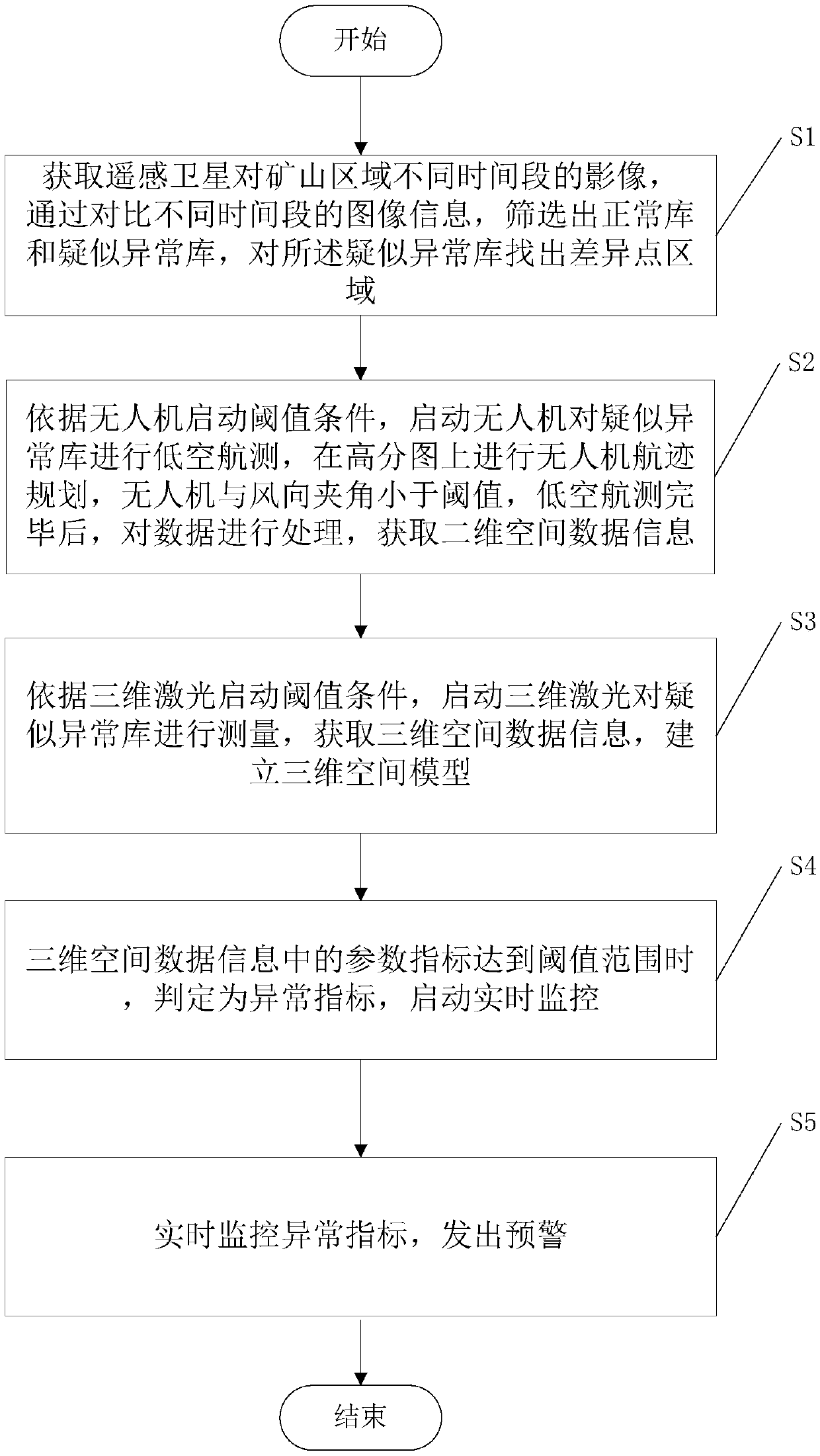
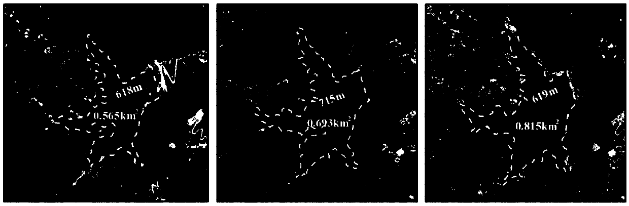
[0034] In this embodiment, a certain tailings pond is taken as an example to illustrate the method of the present invention.

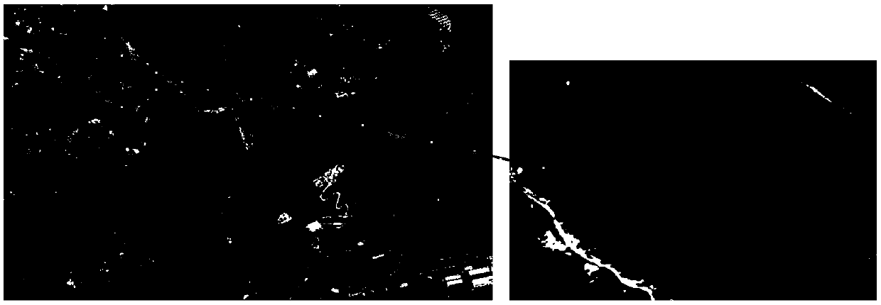
[0035] The first step is to obtain the photos of the mine area taken by remote sensing satellites in different time periods, compare the image information in different time periods, screen out the normal database and the suspected abnormal database, and find out the difference points in the suspected abnormal database.

[0036] Remote sensing satellite remote sensing can periodically conduct continuous observation of ground targets, and the spatial resolution is better than 1m. For mine tailings ponds, when the tailings pond data is established for the first time, according to the position coordinates of the tailings ponds on the remote sensing satellite image Find the location of the tailings pond, establish the first image information file, and delineate the observation area of ​​the tailings pond according to the design plan of the tailings pond, inc...


PUM


Abstract

The invention discloses an air-space-ground integrated measurement and control method for tailings reservoir risk in the technical field of mine safety risk monitoring, the steps including follows: 1.remote sensing satellite photos of different time periods in a mine area are obtained, and then normal libraries and suspected abnormal libraries are screened out, and difference point areas of the suspected abnormal libraries are found out; 2. according to starting threshold condition of unmanned aerial vehicle, the unmanned aerial vehicle is started to conduct low-altitude aerial survey of thesuspected abnormal libraries to obtain two-dimensional spatial data information; 3. according to starting threshold condition of three-dimensional laser, the three-dimensional laser is started to measure the suspected abnormal libraries to obtain three-dimensional spatial data information and establish a three-dimensional spatial model; 4. when the parameters index of the three-dimensional spatialdata information reaches the threshold range, real-time monitoring is started; 5. abnormal indicators are monitored in real time and early alert is issued. The air-space-ground integrated measurement and control method for the tailings reservoir risk realizes the multi-level monitoring of tailings reservoir in a wide range, and obtains the parameters data of the tailings reservoir in time, quantitatively and at low cost, and can alert the risk.

Description

technical field [0001] The invention relates to the technical field of mine safety risk monitoring, in particular to a tailings pond risk space-air-ground integrated measurement and control method. Background technique [0002] Tailings pool refers to the place where dams are built to intercept valley mouths or enclosures, and are used to stockpile metal or non-metal mines for ore sorting and then discharge tailings or other industrial waste. The tailings pond is a high potential energy man-made debris flow hazard, and there is a danger of dam failure. Once the accident occurs, it is easy to cause serious accidents. Regarding the environmental risk assessment and monitoring of tailings ponds, my country is in the stage of gradually advancing and becoming more mature. [0003] In the prior art, common monitoring methods for tailings ponds include: remote sensing satellites, three-dimensional lasers, and the like. Remote sensing satellite images have the advantages of large-...

Claims


Application Information

Patent Timeline
IPC IPC(8): G01D21/02G08B31/00
CPCG01D21/02G08B31/00
Inventor 施富强蒋耀港廖学燕王立娟黄泽贾虎军马国超黄慧勇张铱莹刘承雨施轶凡龚志刚周帅唐梓洋
Owner 四川省安全科学技术研究院
Why Eureka
Try Eureka