Surveying and mapping unmanned aerial vehicle capable of automatically adjusting balance

An automatic adjustment, unmanned aerial vehicle technology, applied in the field of surveying and mapping unmanned aerial vehicles, can solve problems such as the offset of the center of gravity, unbalance, and the surveying and mapping work cannot be carried out normally, and achieve the effect of reducing the load and compacting the structure.

Active Publication Date: 2019-05-07
CHONGQING VOCATIONAL INST OF ENG
View PDF6 Cites 5 Cited by
  • Summary
  • Abstract
  • Description
  • Claims
  • Application Information

AI Technical Summary

Problems solved by technology

[0004] The present invention intends to provide a surveying and mapping unmanned aerial vehicle that can automatically adjust the balance, so as to solve the imbalance of the existing surveying and mapping unmanned aerial vehicle due to the reduction of the oil volume of the fuel tank and the shift of the center of gravity during the use of the existing surveying and mapping work. Problems that don't work

Method used


Image

  • Surveying and mapping unmanned aerial vehicle capable of automatically adjusting balance
  • Surveying and mapping unmanned aerial vehicle capable of automatically adjusting balance

Examples


Embodiment 2

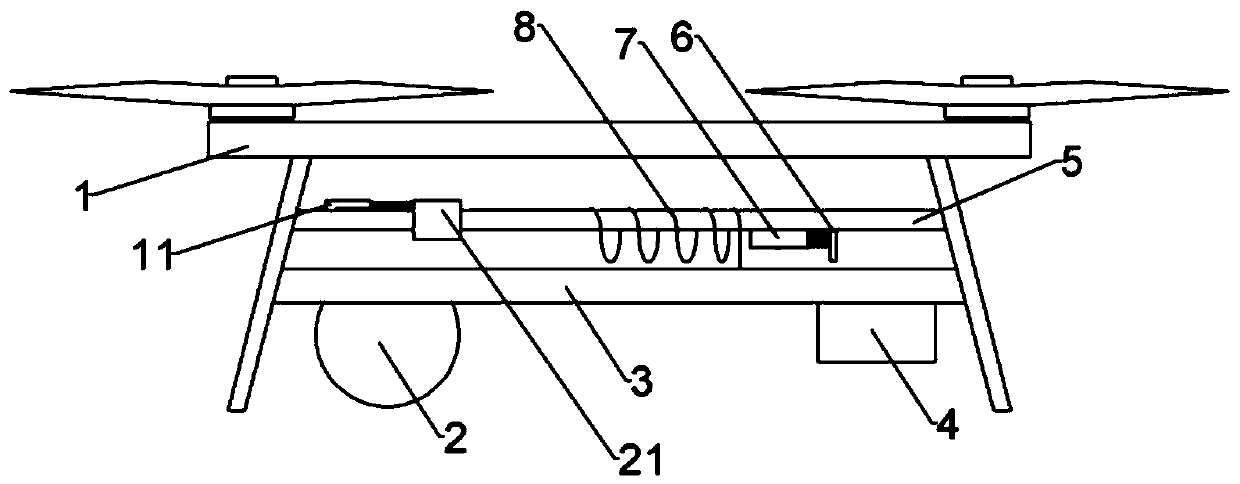
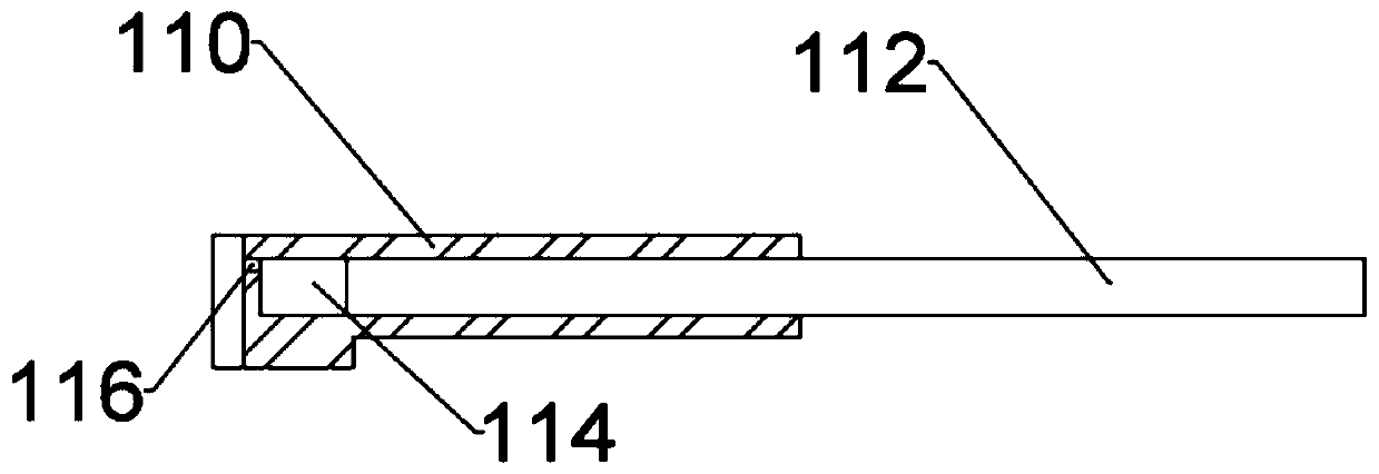
[0026] The difference from Embodiment 1 is that in this embodiment, the oil tank 4 is a cuboid with an open upper end, an oil cavity is arranged inside the oil tank 4, and a floating plate that can float on the oil surface is slidably connected in the oil tank 4, and the upper surface of the floating plate is A pressure rod is connected, and the upper end of the pressure rod passes through the opening and stretches out of the fuel tank 4; The air inlet, the air inlet communicates with the upper end of the connection cavity, the air inlet 116 of the air inlet is provided with a valve that can be opened inwardly; the right end of the slider 7 is connected with a push rod, and the right end of the push rod passes through the connecting rod 6 And extend into the connection cavity, the push rod is slidably connected with the connection rod 6, and during the sliding process of the slider 7, the right end of the push rod slides in the connection cavity all the time.

[0027] The spec...


PUM


Abstract

The invention relates to the technical field of surveying and mapping unmanned aerial vehicle equipment. In order to solve a problem that surveying and mapping works of an existing surveying and mapping unmanned aerial vehicle cannot be normally carried out in the using process because centre-of-gravity shift is caused by reducing of the fuel quantity in a fuel tank to generate unbalance, the invention provides a surveying and mapping unmanned aerial vehicle capable of automatically adjusting balance. The surveying and mapping unmanned aerial vehicle capable of automatically adjusting the balance comprises a body mounted with a camera; the body comprises a fuel system for providing a fuel system; the fuel system comprises the fuel tank, wherein the body further comprises a mounting seat; the camera is mounted at one end of the mounting seat; the fuel tank is positioned at the other end of the mounting seat; a mounting cross rod is also arranged on the body; a battery module is slidingly connected to the mounting cross rod; a lead is connected between the battery module and the camera; a spiral section is arranged on the lead; the spiral section externally sleeves one end, close tothe fuel tank, of the mounting cross rod; an iron patch is arranged on one side, facing towards the spiral section, of the battery module; an iron slide block is slidingly connected to the mounting cross rod through an elastic piece; and the slide block is inserted into the spiral section after sliding far away from the fuel tank.

Description

technical field [0001] The invention relates to the technical field of unmanned aerial vehicle equipment for surveying and mapping, in particular to a surveying and mapping unmanned aerial vehicle that can automatically adjust the balance. Background technique [0002] Surveying and mapping is surveying and drawing. It is based on computer technology, photoelectric technology, network communication technology, space science, and information science. It takes Global Navigation Satellite System (GNSS), Remote Sensing (RS) and Geographic Information System (GIS) as its technical core. The existing feature points and boundaries on the ground are measured to obtain graphics and position information reflecting the current situation of the ground, which are used for planning, design and administrative management of engineering construction. Due to terrain factors, the way of installing cameras on drones is often used nowadays Conduct aerial mapping. [0003] At present, the drone ...

Claims


Application Information

Patent Timeline
Patent Type & Authority Applications(China)
IPC IPC(8): B64C17/02B64C39/02
Inventor 林元茂周孝欢
Owner CHONGQING VOCATIONAL INST OF ENG
Why Eureka
Try Eureka