On-satellite autonomous imaging task planning system

A mission planning and imaging technology, applied in informatics, instruments, etc., can solve problems such as unclear specific environment, satellite safety issues, large amount of command data, etc., and achieve the effect of avoiding command programming errors

Active Publication Date: 2019-05-10
AEROSPACE DONGFANGHONG DEV LTD
View PDF9 Cites 10 Cited by
  • Summary
  • Abstract
  • Description
  • Claims
  • Application Information

AI Technical Summary

Problems solved by technology

[0002] At present, most remote sensing satellites require ground personnel to arrange complex imaging tasks, with a large amount of command data and cumbersome process; the increase in the number of satellites in orbit and the geographical restrictions of the measurement an

Method used


Image

  • On-satellite autonomous imaging task planning system
  • On-satellite autonomous imaging task planning system

Examples


Embodiment Construction

[0020] The present invention will be further described below in conjunction with the accompanying drawings and specific embodiments.

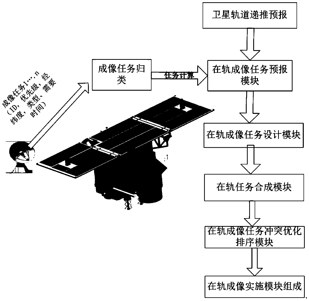
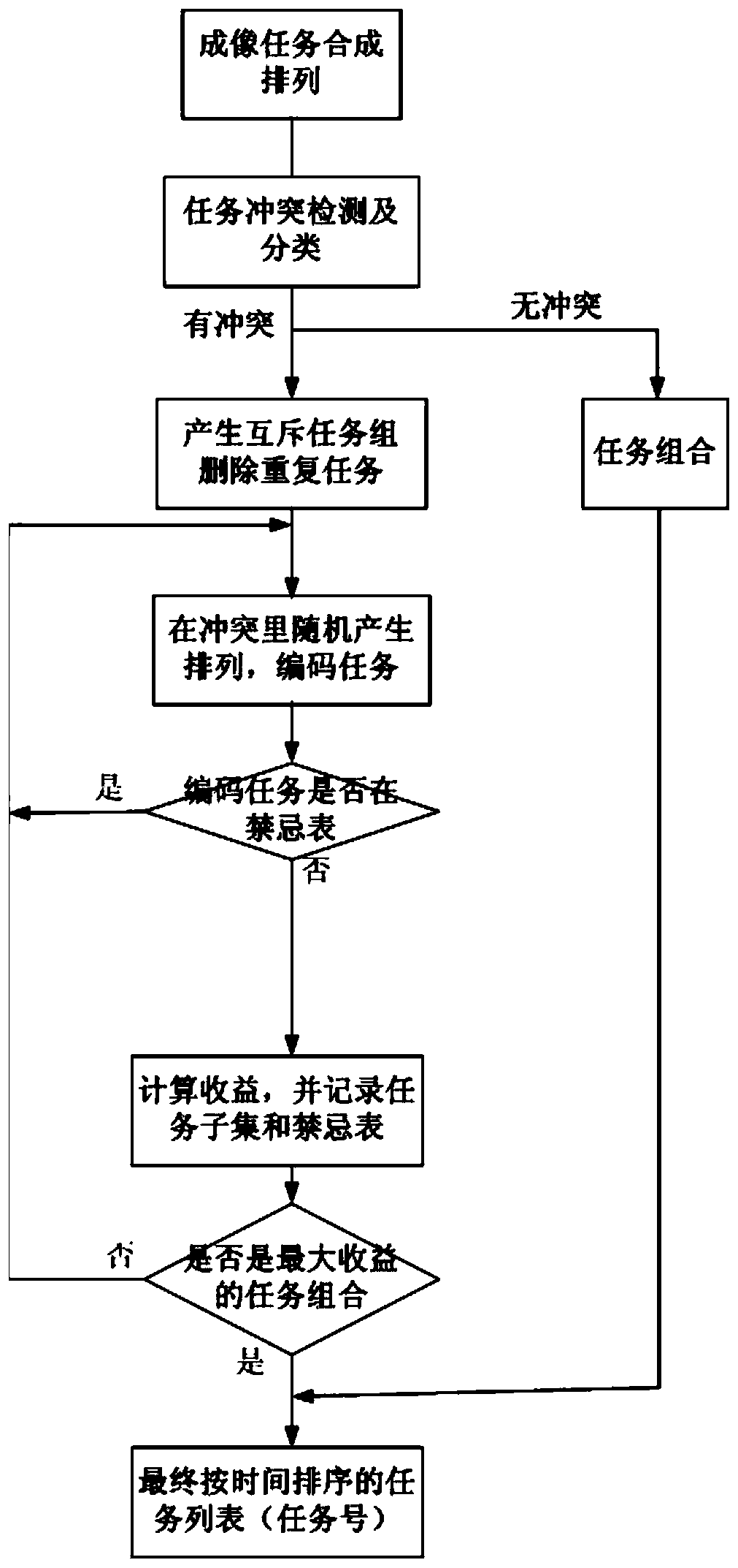
[0021] Such as figure 1 As shown, the on-board autonomous imaging mission planning system of the present invention consists of a satellite orbit recursive prediction module, an on-orbit imaging mission prediction module, an on-orbit imaging mission design module, an on-orbit mission synthesis module, an on-orbit imaging mission conflict optimization sorting module and On-orbit imaging implementation module composition.

[0022] The satellite orbit recursive prediction module takes the real-time navigation information of the GPS receiver as input, combines the EOP parameters to realize the determination of the quasi-plain root of the orbit, and then forecasts the orbit position of the satellite for a period of time (one week) in the future based on the quasi-plain root. The satellite orbit recursive prediction module contains two sub-modules, t...


PUM


Abstract

The invention provides an on-satellite autonomous imaging task planning system. The on-satellite autonomous imaging task planning system comprises a satellite orbit recursion forecasting module, an on-orbit imaging task forecasting module, an on-orbit imaging task design module, an on-orbit task synthesis module, an on-orbit imaging task conflict optimization sorting module and an on-orbit imagingimplementation module. A satellite user only needs to send longitude and latitude of an imaging area to a satellite. The satellite autonomously calculates the imaging time, calculates and sets imaging and control parameters and intelligently arranges imaging, a user does not need to understand a complex satellite design and use method, then imaging of a target area is completed conveniently, rapidly and efficiently, and meanwhile the situation that instruction arrangement errors affect the safety of the satellite is avoided. The on-orbit task synthesis module synthesizes adjacent tasks meeting conditions according to constraints such as satellite attitudes, imaging sensors and imaging time to generate a new task sequence.

Description

technical field [0001] The invention relates to the technical field of satellite mission planning systems, in particular to an on-board autonomous imaging mission planning system. Background technique [0002] At present, most remote sensing satellites require ground personnel to arrange complex imaging tasks, with a large amount of command data and cumbersome process; the increase in the number of satellites in orbit and the geographical restrictions of the measurement and control network limit the uplink tasks; the specific environment on the satellite is not clear when imaging , It is easy to cause satellite safety problems; satellite users are inconvenient to use, require professional aerospace knowledge, and the operation is complicated. [0003] Therefore, how to design a system in which the user does not need complex operations and professional knowledge, but only needs to send the latitude and longitude of the imaging area to the satellite, and the satellite automati...

Claims


Application Information

Patent Timeline
IPC IPC(8): G16Z99/00
Inventor 张帝廖祥于小龙李春
Owner AEROSPACE DONGFANGHONG DEV LTD
Why Eureka
Try Eureka