
Calibration and calibration method for inertial reference system

A reference system and calibration method technology, applied in the direction of measuring devices, instruments, etc., can solve the problems of large body size and weight, high requirements for operating space, and difficult adjustment of aircraft parking status, so as to achieve low cost and save money , The method is convenient and practical

Inactive Publication Date: 2019-05-21
中航通飞华南飞机工业有限公司
View PDF7 Cites 7 Cited by
  • Summary
  • Abstract
  • Description
  • Claims
  • Application Information

AI Technical Summary

Problems solved by technology

For large aircraft, such as large fire fighting / rescue amphibious aircraft, the size and weight of the aircraft are large, and it is difficult and time-consuming to adjust the parking state of the aircraft. At the same time, the requirements for operating space are also high, and the space of the final assembly plant is difficult to meet its requirements.

Method used


Image

  • Calibration and calibration method for inertial reference system
  • Calibration and calibration method for inertial reference system

Examples


Embodiment Construction

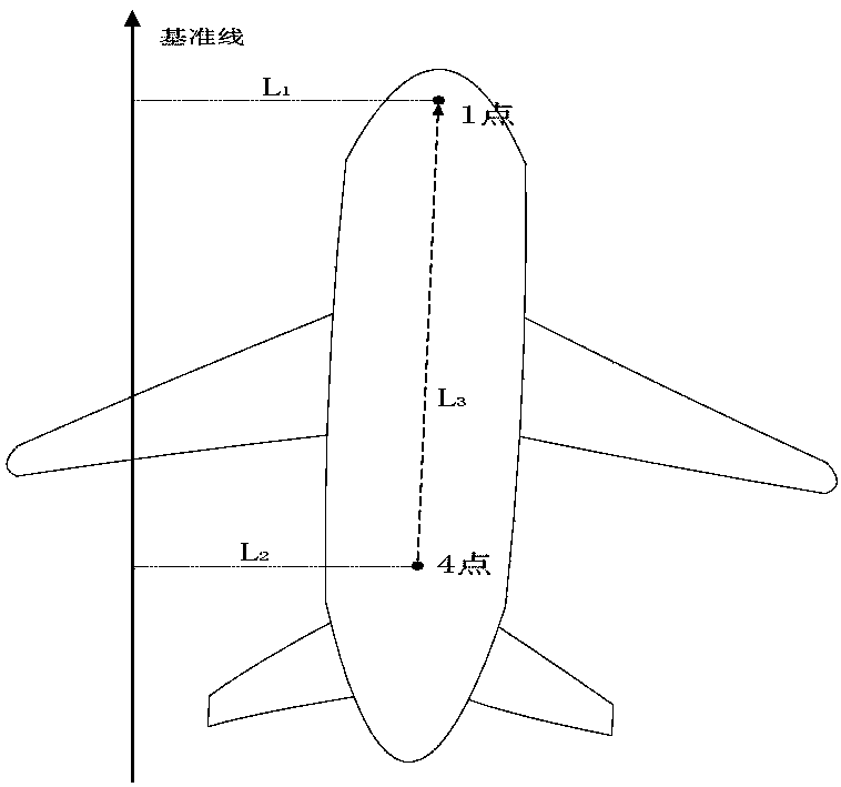
[0019] Such as figure 1 , figure 2 As shown, taking the calibration of the inertial reference system of a large fire fighting / rescue amphibious aircraft as an example, the specific implementation method is as follows:

[0020] 1. Select a target point with a span of more than 5 meters at the station as a reference point, connect the two points into a straight line as the baseline, and use the theodolite to measure the heading angle of the baseline relative to the geographic north of 134°42′57″.

[0021] 2. Select the points on the 4th frame (1st calibration point) and 55th frame (4th calibration point) of the fuselage bottom on the symmetrical axis of the aircraft, and use the laser tracker to measure the coordinates of the two points in the coordinate system where the ground target is located. coordinate. The first calibration point (2957.958, -18.693, -450.159), the fourth calibration point (29013.946, 78.252, -190.782).

[0022] 3. Calculate the vertical distance from t...


PUM


Abstract

The invention relates to a calibration method for an inertial reference system, which is characterized in that on the premise of ensuring that the installation precision of the inertial reference component meets the requirement, a mutual relation is established between a standing ground target point and the symmetry axis of the aircraft, the course angle of a target datum line is measured, the distance between the aircraft and the datum line of the aircraft is converted, and the position parameters of the aircraft are input into calibration software to complete the calibration of the inertialreference system. The method guarantees the calibration precision of the inertial reference system, is convenient and practical, is low in cost by using the existing production conditions, and saves the fund.

Description

technical field [0001] Calibration calibration method for equipment with high installation requirements in navigation system. Background technique [0002] At present, the common calibration of inertial reference system is to align the axis of symmetry of the aircraft with the North Pole using precision instruments for measuring azimuth, and then use calibration software to calibrate. Although this method is straightforward, it has high requirements for testing instruments, and it is necessary to mark the course line of geographic north on the test site, and then adjust the symmetrical axis of the aircraft to a position parallel to the course line. For large aircraft, such as large fire fighting / rescue amphibious aircraft, the size and weight of the aircraft are large, and it is difficult and time-consuming to adjust the parking state of the aircraft. At the same time, the requirements for operating space are also high, and the space of the final assembly plant is difficult ...

Claims


Application Information

Patent Timeline
IPC IPC(8): G01C25/00
Inventor 张敏杨息军冯宇傅建斌
Owner 中航通飞华南飞机工业有限公司
Learn More