Unmanned aerial vehicle autonomous tracking and positioning system and method based on network RTK

A positioning system and network positioning technology, used in radio wave measurement systems, positioning, measuring devices and other directions, can solve the problems of uncertain positioning coordinates, positioning offsets, large errors, etc., to achieve strong anti-interference ability, stable operation, The effect of improving accuracy

Active Publication Date: 2019-05-21
成都优艾维智能科技有限责任公司 +1
View PDF10 Cites 4 Cited by
  • Summary
  • Abstract
  • Description
  • Claims
  • Application Information

AI Technical Summary

Problems solved by technology

[0003] First, direct use of GPS data for positioning, the positioning accuracy is within 2.5 meters, and the error is large;
[0004] Second, the conventional RTK base station positioning UAV, because there is an offset in the positioning of the RTK base station, and the offset cannot be copied, and the offset is irregular, resulting in irregular positioning of the UAV, and the irregular positioning of the UAV can be found , although the RTK positioning accuracy can reach the centimeter level, it is only for fixed object positioning and is not suitable for UAV autonomous tracking high-precision positioning; for example, the first positioning coordinates of a conventional RTK base station (x 0 ,y 0 ,z 0 ), the offset is (Δx i ,Δy i ,Δz i ), i=2, 3, 4...n; i represents the number of times of collecting base station positioning offsets; the second positioning offset, the third positioning offset, the fourth positioning offset, until the nth When the secondary positioning is offset, the actual base station positioning coordinates are (x 0 +Δx i ,y 0 +Δy i ,z 0 +Δz i ); due to the uncertainty of the offset, that is (Δx i ,Δy i ,Δz i )≠(Δx i+1 ,Δy i+1 ,Δz i+1 ), the actual positioning coordinates are also uncertain

Method used


Image

  • Unmanned aerial vehicle autonomous tracking and positioning system and method based on network RTK
  • Unmanned aerial vehicle autonomous tracking and positioning system and method based on network RTK
  • Unmanned aerial vehicle autonomous tracking and positioning system and method based on network RTK

Examples


Embodiment Construction

[0040] The technical solution of the present invention will be further described in detail below in conjunction with the accompanying drawings, but the protection scope of the present invention is not limited to the following description.

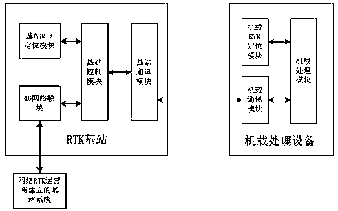
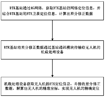
[0041] Such as figure 1 As shown, a UAV autonomous tracking and positioning system based on network RTK, including:

[0042] The RTK base station is used to obtain the network positioning information of the network RTK base station group through the 4G network, combine it with the RTK satellite positioning information of the RTK base station, calculate the positioning and calibration data of the UAV, and transmit it to the onboard processing equipment of the UAV;

[0043] The on-board processing equipment of the drone is used to combine the RTK satellite positioning information of the drone with the positioning calibration data from the RTK base station to calculate the precise position of the drone and realize the precise positioning of th...


PUM


Abstract

The invention discloses an unmanned aerial vehicle autonomous tracking and positioning system and method based on a network RTK. The system comprises an RTK base station and airborne processing equipment of an unmanned aerial vehicle. The RTK base station is used for obtaining network positioning information of a network RTK base station group through a 4G network, combining with the RTK satellitepositioning information of the RTK base station, calculating positioning calibration data of the unmanned aerial vehicle, and transmitting the positioning calibration data to the airborne processingequipment of the unmanned aerial vehicle; and the airborne processing equipment of the unmanned aerial vehicle is used for combining the RTK satellite positioning information of the unmanned aerial vehicle with the positioning calibration data from the RTK base station to calculate the precise position of the unmanned aerial vehicle and realize the precise positioning of the unmanned aerial vehicle. The differential correction data are calculated through the network positioning information of the RTK base station and the RTK satellite positioning information and transmitted to the unmanned aerial vehicle for positioning correction, the positioning accuracy of the unmanned aerial vehicle is improved. The system has the advantages of being high in anti-interference capacity and stable in operation.

Description

technical field [0001] The invention relates to UAV positioning, in particular to a network RTK-based UAV autonomous tracking and positioning system and method. Background technique [0002] At present, the demand for drones in the industrial field is increasing, and they are used in various aspects such as national defense, agriculture, electric power, fire protection, and public security. There is a great demand for some occasions that cannot be successfully completed by conventional manpower; When man-machine, it is often necessary to locate the drone. For now, the positioning methods of the drone mainly include the following three types: [0003] First, direct use of GPS data for positioning, the positioning accuracy is within 2.5 meters, and the error is large; [0004] Second, the conventional RTK base station positioning UAV, because there is an offset in the positioning of the RTK base station, and the offset cannot be copied, and the offset is irregular, resulting ...

Claims


Application Information

Patent Timeline
IPC IPC(8): G01S5/14
Inventor 张明君陈龙杨俊峰
Owner 成都优艾维智能科技有限责任公司
Why Eureka
Try Eureka