Eureka AIR delivers breakthrough ideas for toughest innovation challenges, trusted by R&D personnel around the world.

Device and method for acquiring road information from map data

A technology for map data and road information, applied in the computer field, can solve the problems of slow manual marking, low map drawing efficiency, and insufficient data accuracy to support autonomous driving scenarios.

Active Publication Date: 2019-05-24
GUANGZHOU WERIDE TECH LTD CO
View PDF9 Cites 26 Cited by
  • Summary
  • Abstract
  • Description
  • Claims
  • Application Information

AI Technical Summary

Problems solved by technology

[0004] The existing road information extraction methods mainly rely on manual marking, that is, manually marking the information in the point cloud data. Due to the slow speed of manual marking, the efficiency of map drawing is low
[0005] On the other hand, traditional maps contain rich road information, but the precision of the data is not enough to support autonomous driving scenarios

Method used


Image

  • Device and method for acquiring road information from map data
  • Device and method for acquiring road information from map data
  • Device and method for acquiring road information from map data

Examples


Embodiment Construction

[0080] In order to make the purpose, technical solution and advantages of the present application clearer, the present application will be further described in detail below in conjunction with the accompanying drawings and embodiments. It should be understood that the specific embodiments described here are only used to explain the present application, and are not intended to limit the present application.

[0081] The method for obtaining road information from map data provided in this application can be applied to vehicle-mounted devices, terminals or servers, wherein the terminals can be personal computers, notebook computers, smart phones, tablet computers, and the like. This method can be applied in autonomous driving scenarios.

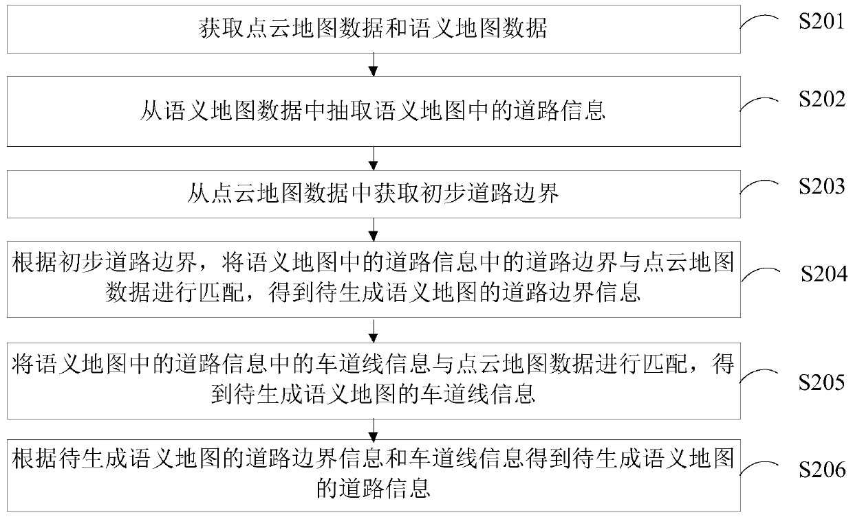
[0082] In one embodiment, such as figure 1 As shown, a method for obtaining road information from map data is provided, including the following steps:

[0083] Step S201, acquiring point cloud map data and semantic map data;

[0084] In this ...


PUM


Abstract

The invention relates to a device and method for acquiring road information from map data. The method includes: acquiring point cloud map data and semantic map data; extracting road information in a semantic map from the semantic map data; acquiring a primary road boundary from the point cloud map data; matching a road boundary in the road information in the semantic map with the point cloud map data to obtain road boundary information of a to-be-generated semantic map; matching lane line information in the road information in the semantic map with the point cloud map data to obtain lane lineinformation of the to-be-generated semantic map; obtaining road information of the to-be-generated semantic map according to the road boundary information and the lane line information of the to-be-generated semantic map. By means of matching of data in a traditional data map with point cloud in high-precision map data, manual annotation is greatly saved, and the map drawing speed is increased.

Description

technical field [0001] The present application relates to the field of computer technology, in particular to a method, device, computer equipment and storage medium for obtaining road information from map data. Background technique [0002] With the development of science and technology, vehicle automatic driving technology is becoming more and more mature. Vehicle automatic driving technology relies on the cooperation of artificial intelligence, visual computing, radar, monitoring devices and global positioning system, so that the computer can operate without any active human operation. , to automatically and safely operate motor vehicles. [0003] Tasks such as obstacle detection, obstacle prediction, and driving planning in vehicle automatic driving technology generally rely on high-precision map data; the existing high-precision map data is mainly point cloud data collected through lidar, from which Extracting road information is a crucial step. [0004] The existing r...

Claims


Application Information

Patent Timeline
Patent Type & Authority Applications(China)
IPC IPC(8): G01C21/30
Inventor 丁欣陈俊杰王志谦
Owner GUANGZHOU WERIDE TECH LTD CO
Why Eureka
Eureka Blog
Learn More