Design method of low-altitude public air route network of unmanned aerial vehicle

A technology of unmanned aerial vehicles and route network, applied in the field of unmanned aerial vehicles, can solve the problems of falling into local optimum and slow convergence speed, and achieve the effect of short time consumption and high search efficiency

Active Publication Date: 2019-05-28
INST OF GEOGRAPHICAL SCI & NATURAL RESOURCE RES CAS +1
View PDF4 Cites 28 Cited by
  • Summary
  • Abstract
  • Description
  • Claims
  • Application Information

AI Technical Summary

Problems solved by technology

The ant colony algorithm successfully and efficiently solves the traveling salesman problem, and has advantages in solving complex optimization problems,

Method used


Image

  • Design method of low-altitude public air route network of unmanned aerial vehicle
  • Design method of low-altitude public air route network of unmanned aerial vehicle
  • Design method of low-altitude public air route network of unmanned aerial vehicle

Examples


Embodiment Construction

[0029] In order to make the objectives, technical solutions and advantages of the present invention clearer, the embodiments of the present invention will be further described in detail below with reference to the accompanying drawings.

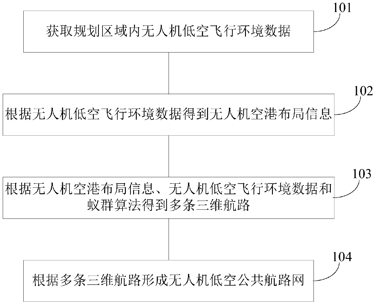
[0030] see figure 1 , the implementation of the present invention provides a method for designing a UAV low-altitude public route network, which includes the following steps:

[0031] Step 101, acquiring the low-altitude flying environment data of the UAV in the planned area.

[0032] Among them, the UAV low-altitude flight environment data (or UAV route planning basic database) is composed of elements that affect the safe flight of UAVs, and UAV flight is closely related to the ground environment and human activities. Therefore, the influencing factors mainly include Basic geography, low-altitude climate, low-altitude communication environment, airspace policy, etc. Basic geographic data mainly includes topographical data, water system distr...


PUM


Abstract

The invention discloses a design method of low-altitude public air route network of an unmanned aerial vehicle, and belongs to the technical field of air route planning. The method includes the following steps that unmanned-aerial-vehicle low-altitude flight environment data in a planning area is obtained; according to the unmanned-aerial-vehicle low-altitude flight environment data, unmanned-aerial-vehicle airport layout information is obtained, wherein the unmanned-aerial-vehicle airport layout information includes location sites of multiple UAV airports and service scopes of the UAV airports; according to the unmanned-aerial-vehicle airport layout information, the unmanned-aerial-vehicle low-altitude flight environment data and the ant colony algorithm, several three-dimensional routesare obtained; according to the several three-dimensional routes, the low-altitude public air route network of the unmanned aerial vehicle is formed. According to the technical scheme, the low-altitudepublic air route network of the unmanned aerial vehicle is constructed, the path search efficiency is higher when an air route is constructed, and less time is consumed.

Description

technical field [0001] The invention belongs to the technical field of unmanned aerial vehicles, and in particular relates to a design method for an unmanned aerial vehicle low-altitude public route network. Background technique [0002] The trajectory planning of UAVs relies on space partitioning methods and trajectory planning algorithms. At present, the space division of trajectory planning mainly adopts unit decomposition, which refers to an efficient method for discretizing the flying airspace environment of UAVs. This method divides the environment into free units and obstacle units, and uses discrete methods to represent the environment; unit The representation methods include Voronoi diagram method and grid method. Among them, the Voronoi diagram constructs the initial optional path set or sets the navigation nodes, and then selects the appropriate path through the optimization algorithm. The disadvantage is that the determination of the location and number of navig...

Claims


Application Information

Patent Timeline
IPC IPC(8): G05D1/10
Inventor 廖小罕徐晨晨岳焕印鹿明缑吉平陈西旺
Owner INST OF GEOGRAPHICAL SCI & NATURAL RESOURCE RES CAS
Why Eureka
Try Eureka