A data processing method and device for raster data
A data processing device and raster data technology, applied in the computer field, can solve problems such as difficult calculation of results, and achieve the effect of improving calculation efficiency
- Summary
- Abstract
- Description
- Claims
- Application Information
AI Technical Summary
Problems solved by technology
Method used
Image
Examples
Embodiment 1
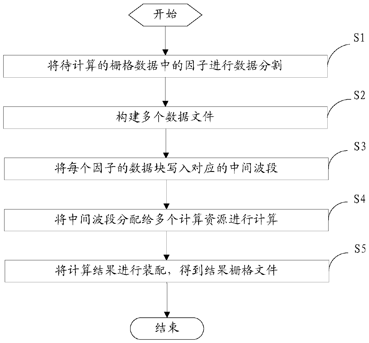
[0039] figure 1 It is a flowchart of a data processing method for raster data according to an embodiment of this application.
[0040] refer to figure 1 As shown, the data processing method adopted in this embodiment is applied to the calculation of the gis-based water erosion model and wind erosion model, and is used to finally obtain the calculation result through the calculation of multiple factors, that is, the result raster data. The data processing method includes the following steps:
[0041] S1. Divide the factors in the raster data to be calculated into data.
[0042] After dividing each factor in the raster data, a preset number of data blocks are obtained. For example, if the raster data contains N factors, the data is divided according to the first factor N1, and divided into M data blocks, for example, divided into 1024*1024 data blocks. It is worth pointing out that, for each factor, after N1 is divided to determine the number of data blocks, the number of da...
Embodiment 2
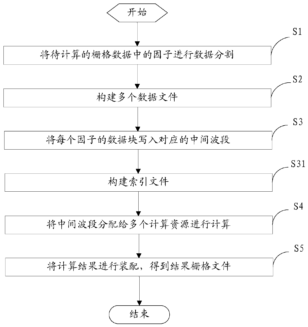
[0054] figure 2 It is a flowchart of another data processing method for raster data according to an embodiment of the present application.
[0055] refer to figure 2 As shown, the data processing method adopted in this embodiment is applied to the calculation of the gis-based water erosion model and wind erosion model, and is used to finally obtain the calculation result through the calculation of multiple factors, that is, the result raster data. The data processing method includes the following steps:
[0056] S1. Divide the factors in the raster data to be calculated into data.
[0057] After dividing each factor in the raster data, a preset number of data blocks are obtained. For example, if the raster data contains N factors, the data is divided according to the first factor N1, and divided into M data blocks, for example, divided into 1024*1024 data blocks. It is worth pointing out that, for each factor, after N1 is divided to determine the number of data blocks, t...
Embodiment 3
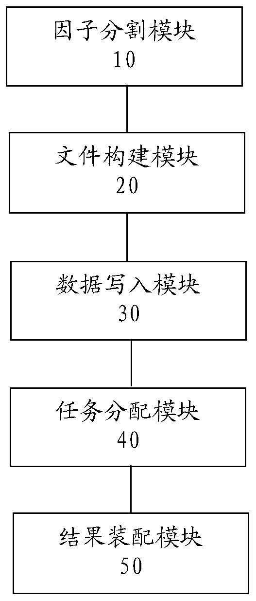
[0072] image 3 It is a block diagram of a data processing device for raster data according to an embodiment of this application.
[0073] refer to image 3 As shown, the data processing device adopted in this embodiment is applied in the calculation of the gis-based water erosion model and wind erosion model, and is used to finally obtain the calculation result through the calculation of multiple factors, that is, the result raster data. The data processing device includes a factor division module 10 , a file construction module 20 , a data writing module 30 , a task assignment module 40 and a result assembly module 50 .
[0074] The factor division module is used to divide the factors in the raster data to be calculated.
[0075] After dividing each factor in the raster data, a preset number of data blocks are obtained. For example, if the raster data contains N factors, the data is divided according to the first factor N1, and divided into M data blocks, for example, div...
PUM
 Abstract
Description
Claims
Application Information
 - R&D
- Intellectual Property
- Life Sciences
- Materials
- Tech Scout
- Unparalleled Data Quality
- Higher Quality Content
- 60% Fewer Hallucinations
Browse by: Latest US Patents, China's latest patents, Technical Efficacy Thesaurus, Application Domain, Technology Topic, Popular Technical Reports.
© 2025 PatSnap. All rights reserved.Legal|Privacy policy|Modern Slavery Act Transparency Statement|Sitemap|About US| Contact US: help@patsnap.com


