A flying measuring system and flying measuring method

A measurement system and laser ranging technology, applied in the field of flightable measurement systems, can solve problems such as inability to measure accurately, and achieve the effects of improving wireless signal reception quality, flexible fixed-point measurement and range measurement, and ensuring positioning measurement accuracy

Active Publication Date: 2020-05-08
BEIJING CNTEN SMART TECH CO LTD +1
View PDF6 Cites 0 Cited by
  • Summary
  • Abstract
  • Description
  • Claims
  • Application Information

AI Technical Summary

Problems solved by technology

[0003] In view of the above problems, the embodiment of the present invention provides a flying measurement system and measurement method to solve the technical problem that the existing RTK measurement system cannot perform accurate measurement in concave terrain

Method used


Image

  • A flying measuring system and flying measuring method
  • A flying measuring system and flying measuring method
  • A flying measuring system and flying measuring method

Examples


Embodiment Construction

[0041] In order to make the purpose, technical solution and advantages of the present invention clearer and clearer, the present invention will be further described below in conjunction with the accompanying drawings and specific embodiments. Apparently, the described embodiments are only some of the embodiments of the present invention, but not all of them. Based on the embodiments of the present invention, all other embodiments obtained by persons of ordinary skill in the art without creative efforts fall within the protection scope of the present invention.

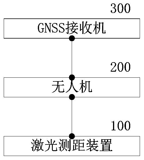
[0042] An embodiment of the present invention can fly the measurement system such as figure 1 shown. exist figure 1 In , the flightable measurement systems include:

[0043] The GNSS receiver 300 is used to receive satellite signals, reference station data links and correction data to form positioning data;

[0044] The UAV 200 is used to carry a GNSS receiver and a laser ranging device, hovering to a designated po...


PUM


Abstract

The invention provides a flight measurement system and a flight measurement method, and solves the technical problem that the existing RTK measurement system cannot perform accurate measurement in a sunken terrain. The system comprises a GNSS receiver used for receiving satellite signals and base station data chain and correction data to form positioning data; a laser ranging device used for measuring the height difference between the unmanned aerial vehicle and the ground when the unmanned aerial vehicle hovers to form correction data; and the unmanned aerial vehicle used for bearing the GNSSreceiver and the laser ranging device and controlled to be suspended to an appointed position. The hovering height of the unmanned aerial vehicle is utilized to avoid multipath interference of homologous wireless signals and improve the receiving sensitivity of the wireless signals. The relative height difference between the unmanned aerial vehicle and the measured position on the ground is obtained by using the mature technology of laser ranging to form correction data, so that the unmanned aerial vehicle can flexibly adjust the hovering height to overcome complex near-field obstacles, the positioning measurement precision of the ground position is ensured, and a reliable guarantee is provided for realizing flexible fixed-point measurement and range measurement.

Description

technical field [0001] The invention relates to the technical field of positioning, in particular to a flying measuring system and measuring method. Background technique [0002] In the prior art, an RTK (Real-time kinematic, real-time dynamic) measurement system is mainly used for field high-precision positioning measurement. A general RTK measurement system includes a GNSS (Global Navigation Satellite System) receiver. The GNSS receiver uses carrier phase difference technology to calculate accurate centimeter-level positioning data using at least four satellite signals combined with a reference station data link. However, when the position to be positioned is located in partially shaded terrain or in some valleys, ravine bottoms and other near-field limited terrain, the GNSS receiver cannot be connected to sufficient satellite signals and wireless data links of the reference station due to the terrain, resulting in failure. Obtain reliable positioning data. Contents of ...

Claims


Application Information

Patent Timeline
Patent Type & Authority Patents(China)
IPC IPC(8): G01S19/42G01S17/08
Inventor 张子罡徐嘉余博尧
Owner BEIJING CNTEN SMART TECH CO LTD
Why Eureka
Try Eureka