Seamless autonomous navigation algorithm for small UAV based on topocentric coordinate system

A technology of small drones and navigation algorithms, which is applied in the field of seamless autonomous navigation algorithms for small drones, can solve the problem of slowly diverging positioning errors, and achieve effective and reliable data

Active Publication Date: 2019-06-25
山东智翼航空科技有限公司
View PDF26 Cites 18 Cited by
  • Summary
  • Abstract
  • Description
  • Claims
  • Application Information

AI Technical Summary

Problems solved by technology

A separate GNSS-assisted inertial navigation system cannot be used in a GNSS-denied environment; visual navigation sensor-assisted inertial navigation, because the visual navigation sensor has requirements for light intensity, flight altitude and spee

Method used


Image

  • Seamless autonomous navigation algorithm for small UAV based on topocentric coordinate system
  • Seamless autonomous navigation algorithm for small UAV based on topocentric coordinate system
  • Seamless autonomous navigation algorithm for small UAV based on topocentric coordinate system

Examples


Embodiment Construction

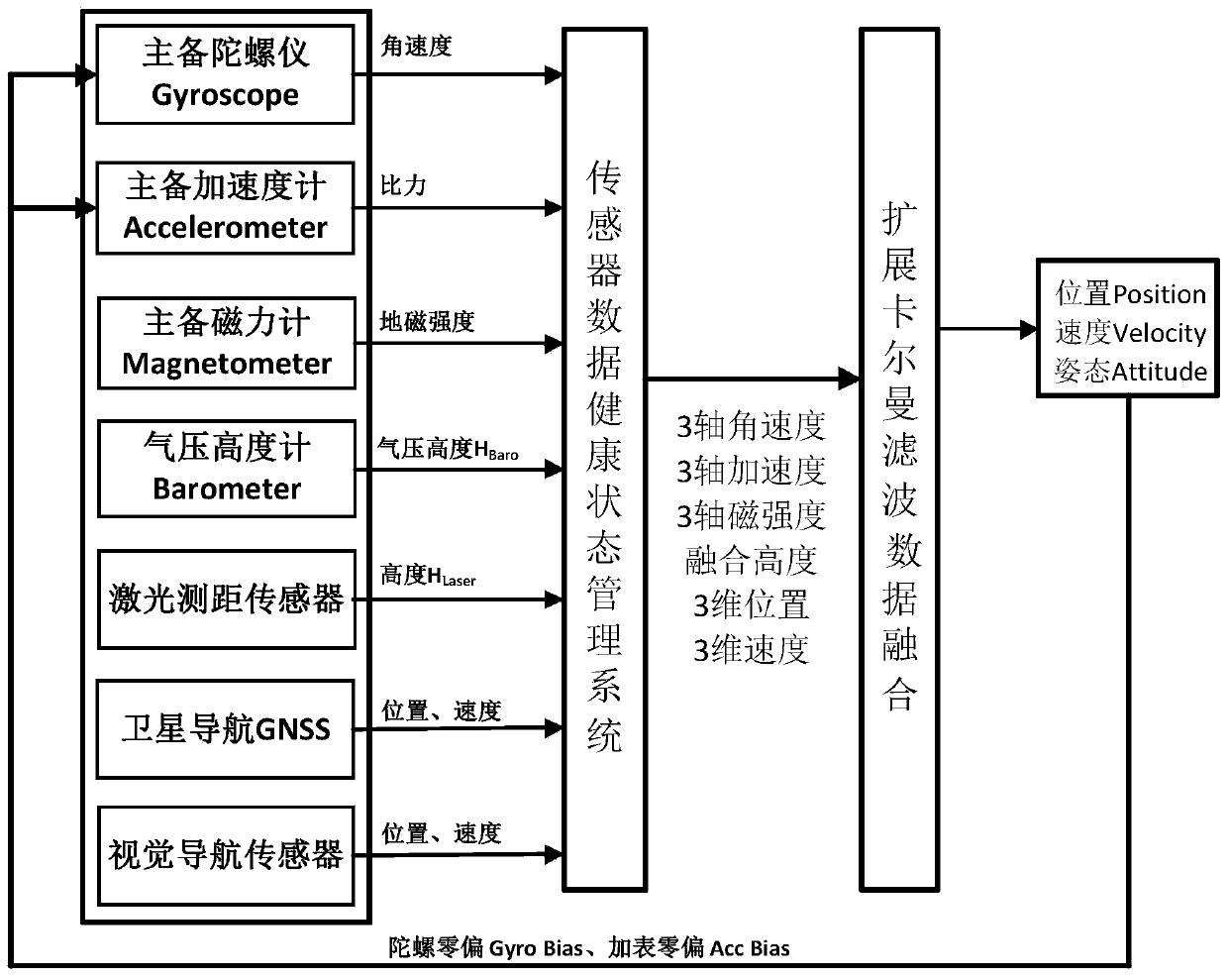
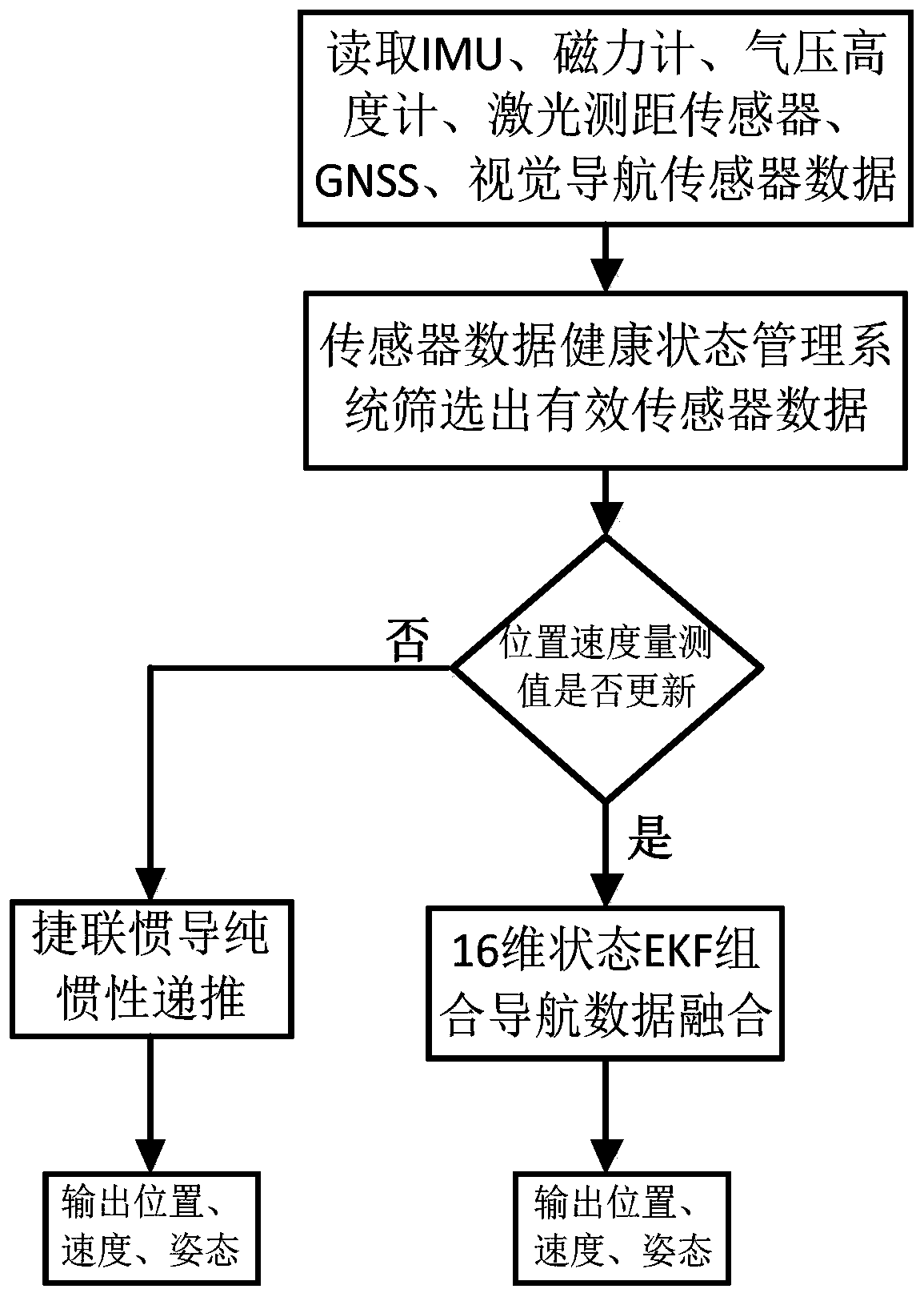
[0102] The present invention will be described in detail in conjunction with accompanying drawing now. This figure is a simplified schematic diagram only illustrating the basic structure of the present invention in a schematic manner, so it only shows the components relevant to the present invention.

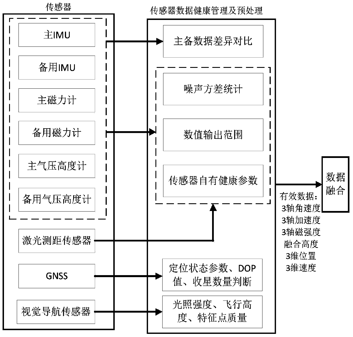
[0103] Such as figure 1 As shown, the navigation system involved in the present invention includes a set of main IMU, main magnetometer and main barometric altimeter, a set of backup IMU, backup magnetometer and backup barometric altimeter, and laser ranging sensor, GNSS and visual navigation sensor, wherein ,

[0104] Among them, the main IMU and the backup IMU both include a three-axis orthogonal gyroscope and a three-axis orthogonal accelerometer, which are used to measure angular velocity and acceleration (specific force), respectively, and can be the same type of sensor, or can be matched in terms of performance; the main IMU Both the magnetometer and the backup magnetome...


PUM


Abstract

The invention provides a seamless autonomous navigation algorithm for a small UAV based on a topocentric coordinate system. The algorithm uses the topocentric coordinate system as a navigation coordinate system, uses multi-sensor redundancy to assist strapdown inertial navigation based on the low-cost MEMS IMU, and uses the extended Kalman filter to complete data fusion so as to solve the location, the speed and the attitude of the UAV. The navigation algorithm uses a sensor data health state management system to adaptively switch the multi-sensor data participating in the navigation data fusion, solidifies a state equation dimension and a range equation dimension, simplifies the data fusion algorithm and ensures the seamless autonomous navigation of the UAV in the presence or absence of GNSS.

Description

technical field [0001] The invention relates to the technical field of integrated navigation algorithms, in particular to a seamless autonomous navigation algorithm for small UAVs based on a center coordinate system. Background technique [0002] With the promotion of the application range of UAVs, it is increasingly required that UAVs have the ability to navigate indoors and outdoors, with or without GNSS positioning environments. A separate GNSS-assisted inertial navigation system cannot be used in a GNSS-denied environment; visual navigation sensor-assisted inertial navigation, because the visual navigation sensor has requirements for light intensity, flight altitude and speed, and ground feature strength, and in order to reduce the amount of calculation and For time-delay, visual navigation sensors often use visual odometer (VO) to assist inertial navigation, and positioning errors will still slowly diverge under long-term navigation. In order to solve the navigation pr...

Claims


Application Information

Patent Timeline
IPC IPC(8): G01C21/00G01C21/20G01C23/00
CPCY02T90/00
Inventor 李德辉王冠林唐宁
Owner 山东智翼航空科技有限公司
Why Eureka
Try Eureka