A Ground Measurement Method for Thermal Infrared Atmospheric Downward Radiation of Sky Hemisphere

A measurement method, thermal infrared technology, applied in geophysical measurement, measurement devices, nuclear radiation exploration, etc., to achieve the effect of eliminating complex calculations, saving material and financial resources, and convenient methods

Inactive Publication Date: 2020-10-09
INST OF GEOGRAPHICAL SCI & NATURAL RESOURCE RES CAS +1
View PDF6 Cites 0 Cited by
  • Summary
  • Abstract
  • Description
  • Claims
  • Application Information

AI Technical Summary

Problems solved by technology

The latter method introduces certain uncertainties only by using a fixed angle measurement, because the observation value of one angle is used to approximate the observation value of the whole hemisphere of the sky. This approximation is often related to the state of the atmosphere and the spectrum of the measuring instrument. Bands are related, and an observation angle is sometimes affected by some clouds and cloud shadows

Method used


Image

  • A Ground Measurement Method for Thermal Infrared Atmospheric Downward Radiation of Sky Hemisphere
  • A Ground Measurement Method for Thermal Infrared Atmospheric Downward Radiation of Sky Hemisphere
  • A Ground Measurement Method for Thermal Infrared Atmospheric Downward Radiation of Sky Hemisphere

Examples


Embodiment Construction

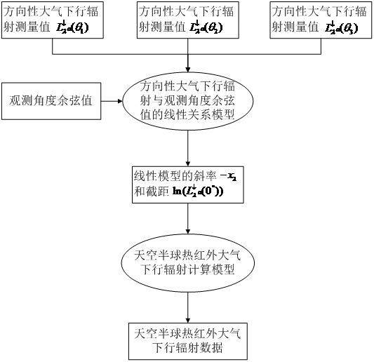
[0030] Such as figure 1 As shown, a ground measurement method for thermal infrared atmospheric downlink radiation in the sky hemisphere, the specific implementation steps are as follows:

[0031] Step 1. Ground measurement of directional thermal infrared atmospheric downlink radiance value:

[0032] 1) Select three different observation angles, denoted as θ 1 , θ 2 , θ 3 , the angle range is 0°~90°, the selected three angle values ​​should be evenly distributed within this angle range as far as possible, such as 0°, 30°, 60°, and the cosine values ​​of the three angles are obtained at the same time, which are recorded as cos(θ 1 ), cos(θ 2 ), cos(θ 3 );

[0033] 2) Use the infrared radiometer to measure the sky at three different selected angles, and the atmospheric downgoing radiation values ​​measured in different directions are recorded as

[0034] Step 2. Parameterization of directional thermal infrared atmospheric down-going radiation values:

[0035] The remot...


PUM


Abstract

The invention discloses a sky hemisphere thermal infrared atmospheric downward radiation ground measurement method. through approximate expression of thermal infrared directional atmospheric downwardradiation, a linear relationship model between directional atmospheric downward radiation and an observation angle cosine value is constructed; and further in combination of an angular integral relationship between the directional atmospheric downward radiation and sky hemisphere atmospheric downward radiation, a simplified model for using a slope and an intercept in the linear relationship modelto calculate the sky hemisphere atmospheric downward radiation is developed. As long as an infrared radiometer on the ground is used to perform three times of measurement on different observation angles of the sky, the slope and the intercept can be fit according to the constructed linear relationship model, and thus, the sky hemisphere thermal infrared atmospheric downward radiation is calculated. The complicated calculation of the hemisphere integral is saved, release of a sounding balloon in the field to acquire atmospheric profile data is not needed either, the infrared radiometer is onlyused on the ground to perform three times of measurement in different directions of the sky, the sky hemisphere thermal infrared atmospheric downward radiation data can thus be quickly obtained, materials and financial resources are saved, and a great significance is achieved in ground verification of a thermal infrared surface temperature remote sensing inversion product.

Description

technical field [0001] The invention relates to a ground measurement method for thermal infrared atmospheric downlink radiation in the sky hemisphere, which is suitable for the correction process of atmospheric radiation in thermal infrared remote sensing, and also suitable for ground verification of thermal infrared surface temperature remote sensing inversion products. Background technique [0002] Atmospheric downgoing radiation is a key component in the study of global radiation balance, mainly water vapor, CO 2 , O 3 Such gas molecules, aerosol particles, and ice crystals in clouds absorb solar radiation and emit long-wave radiation that reaches the surface. The spectrum ranges from 4 microns to 100 microns, that is, the part of the atmosphere's own radiation and scattered long-wave radiation that reaches the ground. As one of the sources of long-wave radiation on the surface, changes in atmospheric downgoing radiation directly affect the radiation budget on the surfac...

Claims


Application Information

Patent Timeline
Patent Type & Authority Patents(China)
IPC IPC(8): G01V5/02
CPCG01V5/02
Inventor 唐伯惠李召良司梦林纪梦豪张子阳
Owner INST OF GEOGRAPHICAL SCI & NATURAL RESOURCE RES CAS
Why Eureka
Try Eureka