Mapping method and system based on GPS, IMU and binocular vision

A map construction and binocular vision technology, applied in radio wave measurement systems, satellite radio beacon positioning systems, measurement devices, etc. problem, to achieve the effect of improving robustness

Pending Publication Date: 2019-07-09
QIMING INFORMATION TECH
View PDF0 Cites 43 Cited by
  • Summary
  • Abstract
  • Description
  • Claims
  • Application Information

AI Technical Summary

Problems solved by technology

[0007] However, most of today's unmanned driving technologies are still in the assisted driving stage, lacking the ability of autonomous positioning and map construction
At the same time, fewer unmanned vehicles use a single sensor for autonomous positioning and map construction. The accuracy of positioning and map construction is low. Stable and effective autonomous positioning and map construction for human-driven cars, and cannot be popularized on a large scale

Method used


Image

  • Mapping method and system based on GPS, IMU and binocular vision
  • Mapping method and system based on GPS, IMU and binocular vision
  • Mapping method and system based on GPS, IMU and binocular vision

Examples


Embodiment 1

[0127] The present invention is based on GPS, IMU and binocular vision autonomous positioning and map construction method and system, comprising the following steps:

[0128] 1. Initialize the pose of the unmanned vehicle or robot, determine the trajectory of the unmanned vehicle or the movement of the robot, correct the data of the IMU inertial measurement unit and the binocular camera to maintain time consistency, and ensure that they are under the same local area network;

[0129] 2. Carry out information collection and extraction of IMU inertial measurement unit, binocular camera and GNSS receiver based on RTK calculation, so as to track visual features;

[0130] 3. IMU pre-integration based on flow pattern, including: IMU pre-integration calculation, calculation of pre-fraction Jacobian and covariance matrix, calculation of residual Jacobian;

[0131] 4. IMU initialization (visual-inertial joint initialization), which is the first step in the fusion of visual and inertial...

Embodiment 2

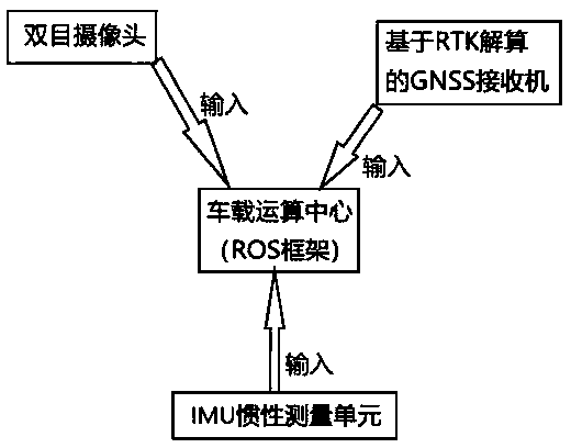
[0142] Such as figure 1 As shown, the map construction system based on GPS, IMU and binocular vision includes a vehicle computing center, a binocular camera, an IMU inertial measurement unit, and a GNSS receiver based on RTK calculation.

[0143] Hardware-level fusion can integrate the binocular camera and IMU on the entire circuit board, and all signal transmission is completed within the circuit board, directly transferring data between the microprocessor controlling the vision system and the microprocessor controlling the IMU In exchange, the performance of the entire system can be improved by upgrading the more detailed information of the environment or target information to the relevant algorithm through visual processing. It is also possible to use pure data interaction and fusion to exchange data between sensors through the data bus. The binocular camera, the IMU inertial measurement unit, and the data output port of the RTK-based GNSS receiver input the collected data...


PUM


Abstract

The invention discloses a mapping method and system based on a GPS, an IMU and binocular vision. A map is corrected through the IMU and the binocular vision, and vision navigation is used in places, where GPS signals do not exist or are weak, such as tunnels. The problems in vision simultaneous localization and mapping (SLAM) can be solved well, and robustness of an SLAM system is improved; and avision information and IMU information fused method is adopted, various sensor data are fused, a new algorithm structure is provided, a stable and effective frame is constructed, stable and effectiveautonomous localization and mapping are conducted on an unmanned vehicle or a robot, positioning information of the GPS is corrected and supplemented, and the mapping method and system are applied tounmanned vehicle and robot systems on a large scale.

Description

[0001] Technical field: [0002] The invention discloses a map construction method and system based on GPS, IMU and binocular vision, relates to an autonomous positioning and map construction system based on visual features and IMU information, and belongs to the field of robot and control technology. [0003] Background technique: [0004] In recent years, the rapid development of Internet technology has brought opportunities for revolutionary changes in the automobile manufacturing industry. At the same time, automotive intelligence technology is gradually being widely used, which simplifies the driving operation of the car and improves driving safety. One of the most typical and popular future applications is driverless cars. With the blessing of artificial intelligence technology, the rapid development of unmanned driving is changing the way people travel, which in turn will change the structure of related industries on a large scale. [0005] For driverless cars driving ...

Claims


Application Information

Patent Timeline
Patent Type & Authority Applications(China)
IPC IPC(8): G01S19/45G01S19/47G01C21/32
CPCG01C21/32G01S19/45G01S19/47
Inventor 孙静拱印生朱庆林张延坤
Owner QIMING INFORMATION TECH
Why Eureka
Try Eureka