Aerial photography and BIM (Building Information Modeling) combination-based earthwork project amount calculation method

A calculation method and engineering quantity technology, applied in calculation, measuring device, surveying and navigation, etc., can solve the problems of difficult calculation of engineering quantity and difficult modeling, so as to reduce engineering cost, improve measurement efficiency and improve measurement accuracy Effect

Inactive Publication Date: 2019-08-02
中铁十八局集团第五工程有限公司 +1
View PDF5 Cites 14 Cited by
  • Summary
  • Abstract
  • Description
  • Claims
  • Application Information

AI Technical Summary

Problems solved by technology

[0003] The purpose of the present invention is to overcome the deficiencies in the prior art and provide a method for calculating the quantity of earthworks based on the

Method used


Image

  • Aerial photography and BIM (Building Information Modeling) combination-based earthwork project amount calculation method
  • Aerial photography and BIM (Building Information Modeling) combination-based earthwork project amount calculation method
  • Aerial photography and BIM (Building Information Modeling) combination-based earthwork project amount calculation method

Examples


Embodiment Construction

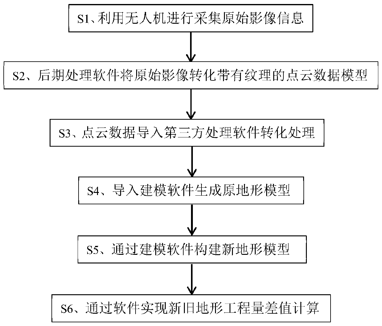
[0027] The present invention will be further described in detail below in conjunction with the drawings and specific embodiments. It should be understood that the specific embodiments described herein are only used to explain the present invention, but not to limit the present invention.

[0028] Such as figure 1 As shown, the present invention protects an earthwork calculation method based on the combination of aerial photography and BIM, which is specifically as follows:

[0029] (1) UAV is used to collect original image information.

[0030] Obtaining information by using drone tilt photography: multiple sensors are mounted on the same flight platform, and images are collected from one vertical and four tilt directions, namely five different angles, to take aerial photography of the construction site with a band-shaped viewing angle. , Include all sites in order, and finally achieve large overlap coverage of the terrain.

[0031] (2) Use the Photoscan real-world modeling software ...


PUM


Abstract

The invention discloses an aerial photography and BIM (Building Information Modeling) combination-based earthwork project amount calculation method. The method comprises the following steps of (1) performing original image information acquisition by utilizing aerial photography of an unmanned aerial vehicle; (2) converting the original image into a point cloud data model with textures through surveying and mapping post-processing software; (3) importing the point cloud data into third-party processing software for conversion processing; (4) importing the converted data file into modeling software to construct an original terrain model; and (5) establishing a new terrain plane or terrain model on the basis of the original terrain model through modeling software; (6) extracting an engineering quantity difference value between the new terrain and the original terrain. According to the invention, based on a mode of combining the aerial photography technology and the BIM technology, the unmanned aerial vehicle is utilized to obtain the original terrain data, the original terrain data is processed through the reverse modeling technology, and the BIM software is utilized to obtain the three-dimensional model, so that not only is the measurement time saved, but also the modeling efficiency is improved, and meanwhile, the data precision is ensured.

Description

Technical field [0001] The invention relates to the field of complex terrain earthwork engineering, in particular to a method for calculating engineering quantities based on a combination of UAV and BIM software. Background technique [0002] With the increasing acceleration of urban development, the expansion space in the central area has been greatly reduced, and the development focus has gradually shifted to the surrounding areas of the urban area. However, since most of the surrounding areas are complex in terrain, they often bring many problems to design and construction. At the same time, most of the contracted municipal and public sector projects are mostly located in remote areas and rugged terrain. Therefore, the problems that accompany it: difficult modeling due to complex topography and unclear drawings; in the pre-settlement of earth and stone engineering quantities, there are often major disputes due to engineering quantity deviations. The penetration and interventi...

Claims


Application Information

Patent Timeline
IPC IPC(8): G06F17/50G01C11/00G06T17/00
CPCG01C11/00G06T17/00G06F30/13G06F30/20
Inventor 闫煜东李汉愿李敏张鹏许杰
Owner 中铁十八局集团第五工程有限公司
Why Eureka
Try Eureka