Vehicle positioning method and system based on dual-antenna GNSS heading and wheel speed assistance

A vehicle positioning and dual-antenna technology, applied in satellite radio beacon positioning systems, radio wave measurement systems, measurement devices, etc., can solve problems such as GNSS signals are susceptible to interference, high sensor performance requirements, and environmental feature point distribution. , to achieve accurate estimation, improve estimation accuracy, and eliminate cumulative errors

Active Publication Date: 2019-08-16
TONGJI UNIV
View PDF5 Cites 7 Cited by
  • Summary
  • Abstract
  • Description
  • Claims
  • Application Information

AI Technical Summary

Problems solved by technology

[0003] At present, most of the localization research points of low-speed electric vehicles in this field at home and abroad are concentrated on position and heading error estimation. The main methods of existing position error and heading estimation are: 1. Using satellite navigation and positioning system (GNSS) to pass RTK carrier phase The difference realizes the precise position and heading calculation, but its robustness is poor, and the GNSS signal is extremely susceptible to interference; 2. The inertial navigation system (INS) is used to realize the position and heading calculation, but this method has the problem of cumulative error; 3. Based on The position and heading estimation of the combination of wheel speed and INS, because this method has no global position correction, there is a problem of cumulative error; 4. The combined position and heading estimation based on sensors such as lidar and vision is seriously affected by the distribution of environmental feature points, and each Sensor performance requirements are high

Method used


Image

  • Vehicle positioning method and system based on dual-antenna GNSS heading and wheel speed assistance
  • Vehicle positioning method and system based on dual-antenna GNSS heading and wheel speed assistance
  • Vehicle positioning method and system based on dual-antenna GNSS heading and wheel speed assistance

Examples


Embodiment Construction

[0042] The present invention will be described in detail below with reference to the drawings and specific embodiments. Obviously, the described embodiments are a part of the embodiments of the present invention, rather than all the embodiments. Based on the embodiments of the present invention, all other embodiments obtained by a person of ordinary skill in the art without creative work shall fall within the protection scope of the present invention.

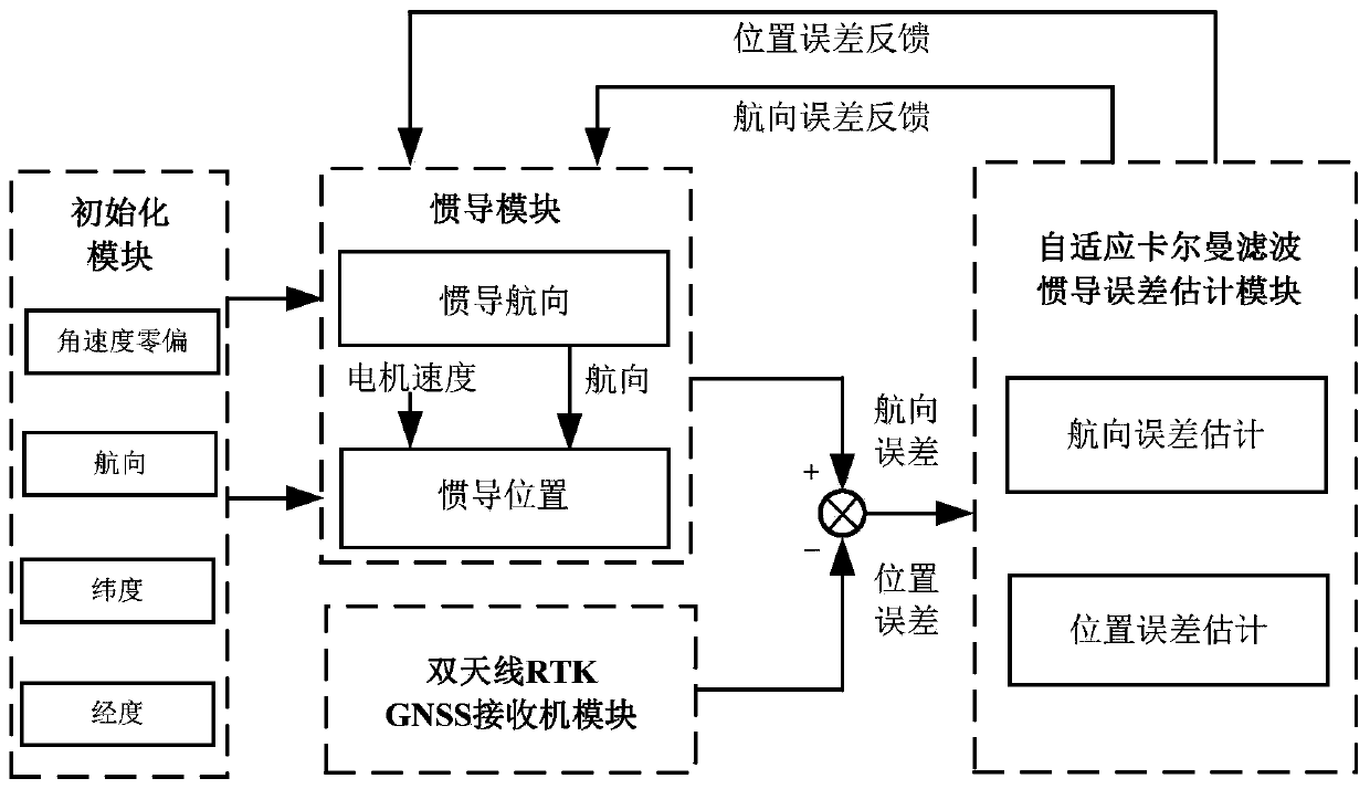
[0043] Such as figure 1 As shown, the present invention relates to a vehicle positioning method based on dual-antenna GNSS heading and wheel speed assistance. The method includes the following steps:

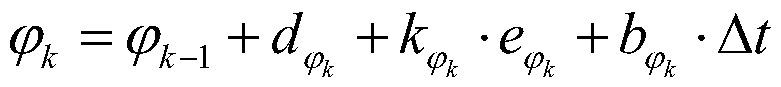
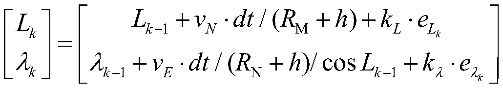
[0044] Step 1. When the vehicle is stationary, within a period of time (about 20-30 seconds), calculate the initial value of the position and heading based on the GNSS antenna position and heading. The calculation method is as follows:

[0045]

[0046]

[0047]

[0048]

[0049] Where L ini , Λ ini And ω ini Respectively indicate...


PUM


Abstract

The invention relates to a vehicle positioning method and system based on dual-antenna GNSS heading and wheel speed assistance. The method includes steps: 1) in a vehicle stationary condition, calculating initial values of position and heading according to positions and headings of GNSS antennas, and obtaining initial values of the position and the heading of a vehicle; 2) estimating the heading of the vehicle according to the initial values of the position and the heading and an angular velocity measured by inertial navigation, and calculating the position corresponding to the heading; 3) calculating an inertial navigation position and an inertial navigation heading according to a rotating speed of a motor and the calculated position corresponding to the heading, and correcting the position and the heading by employing an adaptive Kalman filtering algorithm; and 4) inputting the corrected position and heading to step 2), repeating the above steps, and outputting the final heading andposition to further obtain vehicle positioning information. Compared with the prior art, according to the method and system, vehicle information sources are fully used, the problem of low precision of the output speed of a GNSS receiver at a low speed is solved, and the method and system is advantaged by easy debugging, high estimation precision and small calculation amount.

Description

Technical field [0001] The present invention relates to the technical field of automatic driving, in particular to a vehicle positioning method and system based on dual-antenna GNSS heading and wheel speed assistance. Background technique [0002] Autonomous vehicles have developed rapidly in recent years and have become the focus of competition among vehicle companies and even IT companies. Accurate vehicle position and heading are essential for the realization of automatic driving. Fusion of multi-source information to estimate position, heading and position delay time has become an urgent problem to be solved. [0003] At present, most research points on the positioning of low-speed electric vehicles in this field at home and abroad focus on the estimation of position and heading errors. The main methods of current position error and heading estimation are: 1. Using satellite navigation and positioning system (GNSS) through RTK carrier phase Differential achieves accurate posi...

Claims


Application Information

Patent Timeline
Patent Type & Authority Applications(China)
IPC IPC(8): G01S19/43G01S19/52
CPCG01S19/43G01S19/52
Inventor 熊璐夏新陆逸适高乐天韩燕群胡英杰魏琰超刘伟宋舜辉余卓平
Owner TONGJI UNIV
Why Eureka
Try Eureka