

Oil tank storage capacity determination method and system based on remote sensing image characteristics
A technology for remote sensing images and determining methods, which is applied in the field of remote sensing image processing, and can solve problems such as not calculating the volume of oil tanks and the storage capacity of oil tanks
Active Publication Date: 2019-09-06
CHINA CENT FOR RESOURCES SATELLITE DATA & APPL
View PDF10 Cites 10 Cited by
- Summary
- Abstract
- Description
- Claims
- Application Information
AI Technical Summary
Problems solved by technology
In view of the existing remote sensing image detection methods for oil tanks, the existing technology has the following problems: (1) most of the methods are aimed at detecting oil tanks, and do not calculate the volume and storage capacity of oil tanks; (2) to obtain The volume and tank storage methods assume known values for the sun and satellite azimuths
Method used
View moreImage
Smart ImageViewing Examples

Examples
Embodiment
[0120] This patent uses the Gaofen-2 satellite and Gaojing-1 satellite to monitor Ningbo Daxie port for three periods respectively, and obtain the oil storage rate of 12 floating roof oil tanks in the port, as shown in Table 1, and compare with Comparing the ground investigation, it can be concluded that the error is within 5%.
[0121] Table 1 Comparison table of oil storage rate data of floating roof oil tanks
[0122]
[0123]
Login to View More PUM
 Abstract
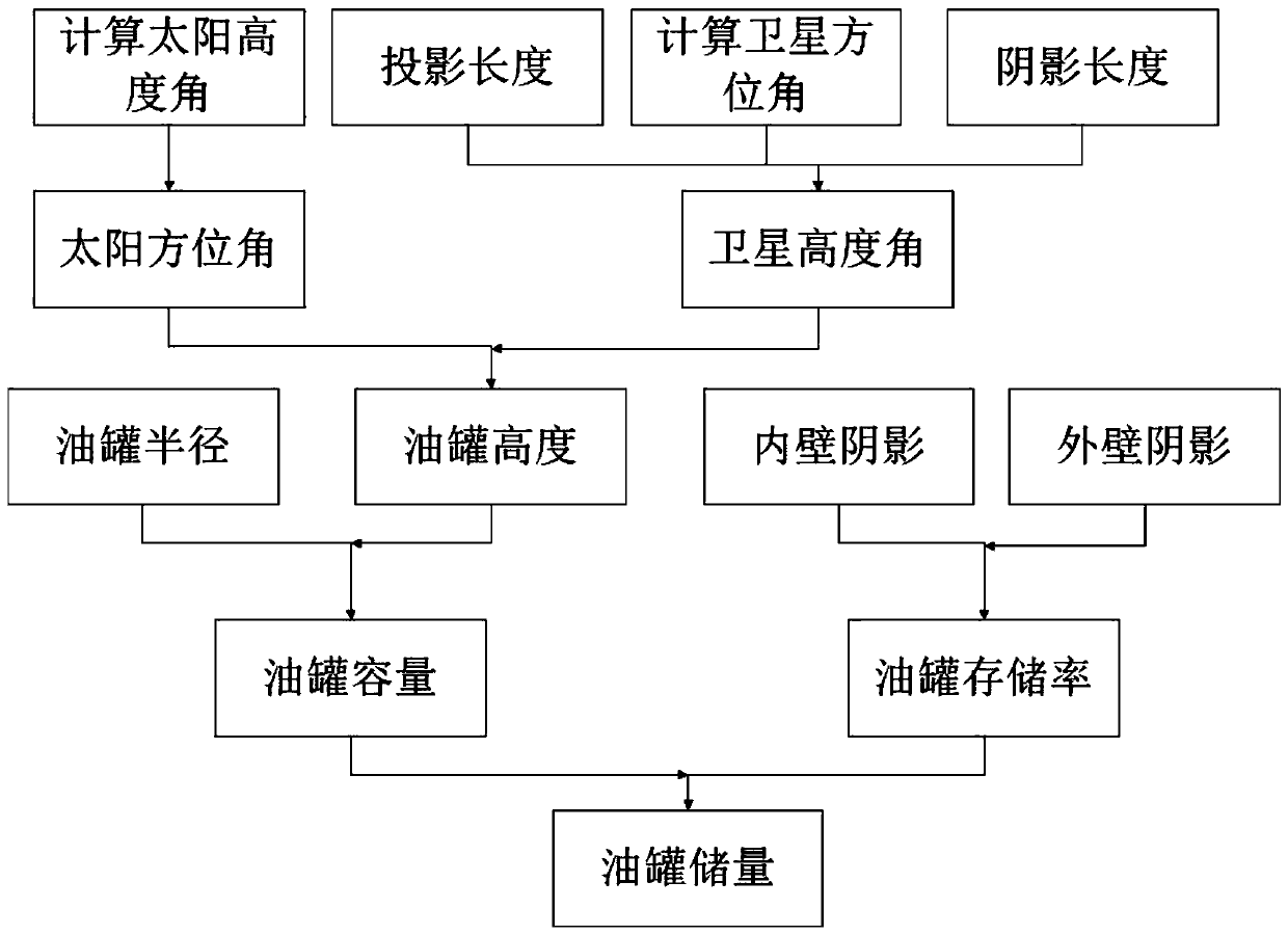
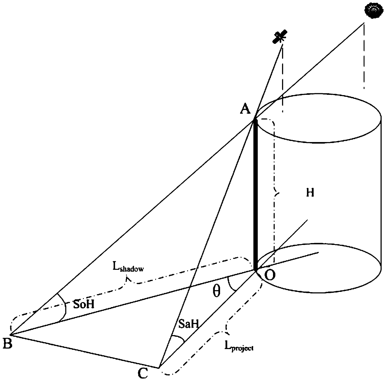
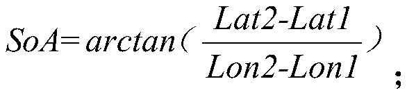
The invention discloses an oil tank storage capacity determination method and system based on remote sensing image characteristics. The method comprises the following steps: (1) in a remote sensing image, calculating a solar azimuth by taking a sharp ground object near an oil tank as a reference; (2) determining an imaging date and a solar elevation angle of the remote sensing image according to asolar azimuth angle; (3) in the remote sensing image, calculating a satellite azimuth by taking the sharp ground object near the oil tank as the reference; (4) calculating a satellite elevation angleaccording to the shadow length, the projection length and the sun elevation angle of the sharp ground object near the oil tank; (5) selecting an oil tank needing to calculate the oil storage amount,and calculating the height of the oil tank by utilizing the tank top shadow length, the projection length, the solar altitude, the solar azimuth, the satellite altitude and the satellite azimuth; (6)calculating the oil tank capacity according to the oil tank height and the oil tank radius; (7) calculating the storage rate of the oil tank by using shadows on the inner wall and the outer wall of the oil tank; and (8) calculating the oil tank storage capacity by using the oil tank capacity and the oil tank storage rate.
Description
technical field [0001] The invention belongs to the field of remote sensing image processing, and in particular relates to a method for estimating the storage capacity of an oil tank according to the optical conditions and the attitude of the satellite during imaging of a domestic optical remote sensing satellite, combined with geometric principles. Background technique [0002] Remote sensing technology is one of the fastest-growing spatial information technologies since the 21st century. Its ability to obtain information on the earth's surface in a wide range, quickly and efficiently has been widely used in different industries. Compared with the method of ground measurement, remote sensing image acquisition of surface information is less costly, and the information obtained is quantitative and more accurate. Therefore, it is a high-tech means to replace traditional methods. Petroleum is a non-renewable resource on the earth. It is mainly used as fuel and gasoline, and is ...
Claims
Login to View More Application Information
Patent Timeline
 IPC IPC(8): G06K9/00G06Q10/06G06Q50/02
CPCG06Q10/06315G06Q50/02G06V20/13
Inventor易维曾湧黄树松陈卫荣
OwnerCHINA CENT FOR RESOURCES SATELLITE DATA & APPL