Satellite/inertial/visual combination navigation system integrity evaluation method

An integrated navigation system and integrity technology, which is applied in the integrity assessment field of multi-sensor integrated navigation systems, can solve the problems of small amount of calculation, the integrity assessment method cannot meet the real-time requirements, etc., so as to avoid delay problems and avoid local State dynamics, easy-to-implement effects

Active Publication Date: 2019-09-20
NANJING UNIV OF AERONAUTICS & ASTRONAUTICS
View PDF7 Cites 9 Cited by
  • Summary
  • Abstract
  • Description
  • Claims
  • Application Information

AI Technical Summary

Problems solved by technology

[0008] The object of the invention of the present invention is to provide a satellite/inertial/visual integrated navigation system integrity evaluation method for the above-mentioned deficiencies in the background technology, which realizes the global optimiza

Method used


Image

  • Satellite/inertial/visual combination navigation system integrity evaluation method
  • Satellite/inertial/visual combination navigation system integrity evaluation method
  • Satellite/inertial/visual combination navigation system integrity evaluation method

Examples


Embodiment Construction

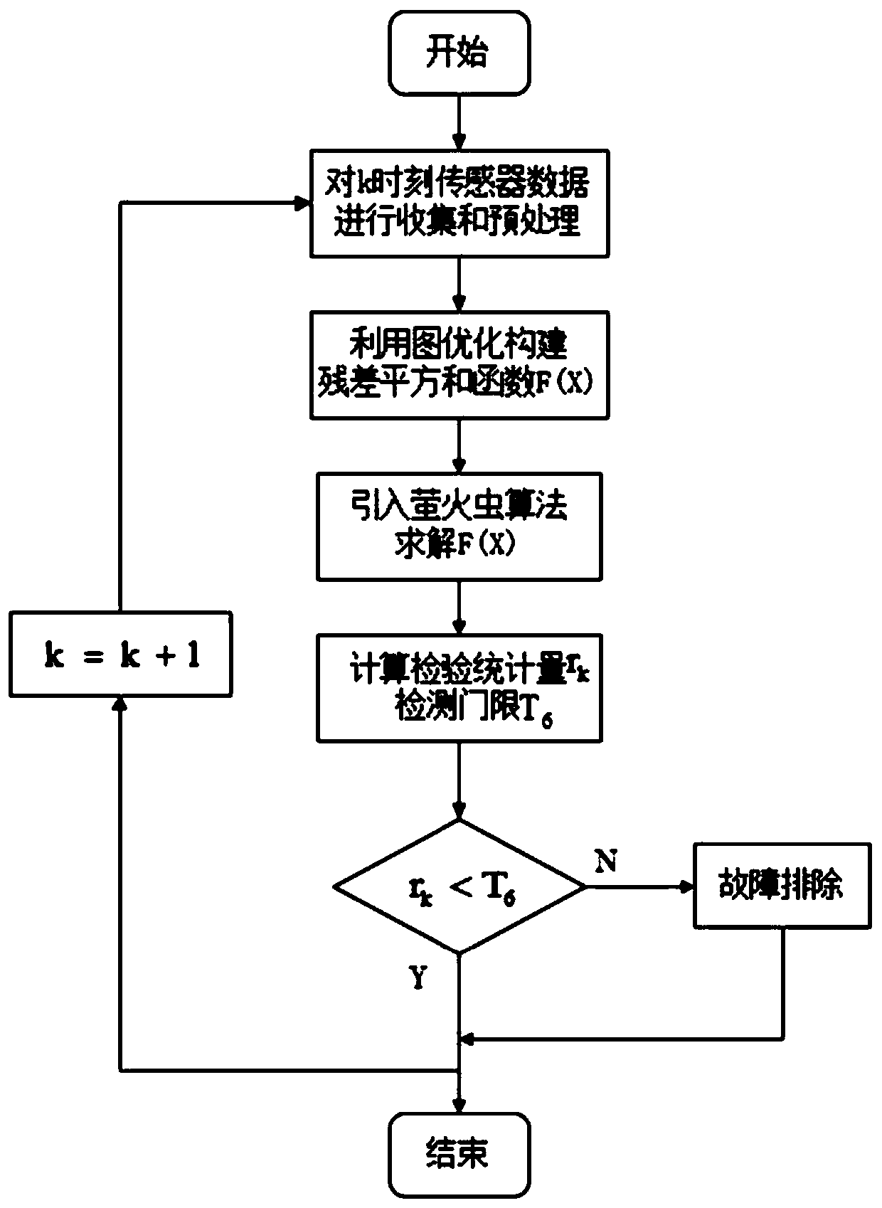
[0019] The technical solution of the invention will be described in detail below in conjunction with the accompanying drawings.

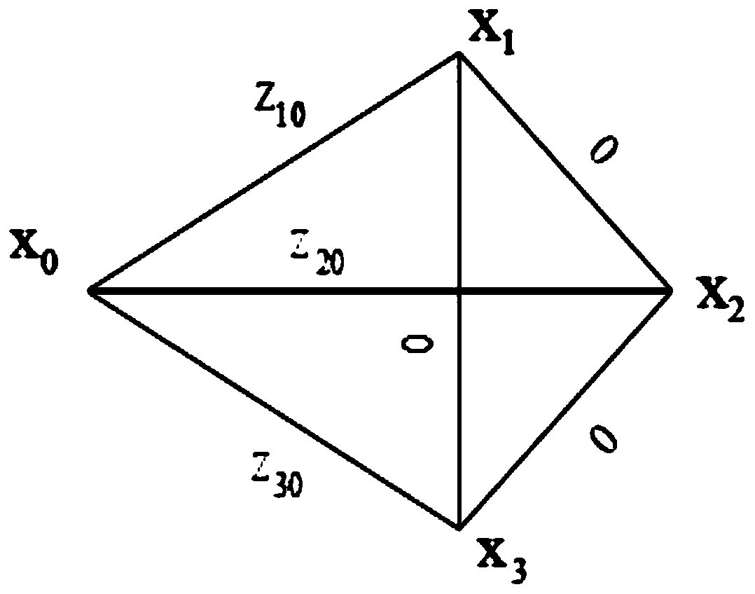
[0020] In order to meet the continuously improving positioning technology accuracy and reliability requirements, the present invention discloses a combination method of firefly algorithm and graph optimization, which is used to evaluate the integrity of satellite / inertial / visual odometer integrated navigation system (integrity includes two aspects The meaning of: first, for any fault exceeding the alarm threshold, a warning must be issued within a given alarm time; second, the integrity risk probability must be within a certain range, and the integrity risk probability means that the navigation position information exceeds the alarm threshold. is the probability that this event is missed).

[0021] Visual odometry mainly relies on visual sensors connected to moving objects, such as monocular cameras, to determine the motion of the robot by analyzing...


PUM


Abstract

The invention discloses a satellite/inertial/visual combination navigation system integrity evaluation method, relates to integrity evaluation of a multi-sensor combination navigation system and belongs to the calculating, reckoning and counting technology fields. In the method, a measured value of each sensor at current time is preprocessed to obtain an observation vector of each sensor at the current time, and the observation vector of each sensor at the current time is expressed as multiple edges having a common pose node. A relationship between the pose node and the edges is used, graph optimization is used to construct a residual weighted quadratic sum function, and a firefly algorithm with high robustness is adopted to optimize the pose node to solve an optimal solution of the residual weighted quadratic sum function and realize a global optimum. And then, test statistics is calculated and the test statistics is compared with a detection threshold so as to determine whether there is a fault. A system calculation amount is reduced, a time delay problem caused by sudden increase of memory consumption over time is avoided, and a real-time detection requirement can be satisfied.

Description

technical field [0001] The invention discloses a method for evaluating the integrity of a satellite / inertial / vision integrated navigation system, relates to the integrity evaluation of a multi-sensor integrated navigation system, and belongs to the technical field of calculation, calculation and counting. Background technique [0002] In recent years, MEMS (Micro-Electro-Mechanical System, Micro-Electro-Mechanical System) sensors, MSIS (Micro Solid-state Inertial Sensor, tiny solid-state inertial sensor), fiber optic gyroscope and GNSS (Global Navigation Satellite System, Global Navigation Satellite System) receivers, etc. New low-cost, small, light-weight navigation sensors, high-speed and large-capacity embedded microprocessors and distributed modular electronic devices have developed rapidly, and a wave of research on multi-sensor navigation systems has arisen. [0003] In order to improve the accuracy and reliability of the multi-sensor navigation system, experts at home...

Claims


Application Information

Patent Timeline
IPC IPC(8): G01C25/00
CPCG01C25/00G01C25/005
Inventor 孙蕊王均晖程琦
Owner NANJING UNIV OF AERONAUTICS & ASTRONAUTICS
Why Eureka
Try Eureka