Road-level global environment map generation method for unmanned driving

A global environment, unmanned driving technology, applied in the direction of instruments, character and pattern recognition, computer components, etc., can solve the problems of inaccurate weather conditions and low production costs, and achieve high accuracy and precision, good positioning accuracy Effect

Active Publication Date: 2019-09-20
UNIV OF ELECTRONIC SCI & TECH OF CHINA
View PDF7 Cites 8 Cited by
  • Summary
  • Abstract
  • Description
  • Claims
  • Application Information

AI Technical Summary

Problems solved by technology

Many traditional unmanned vehicles use GPS for map drawing. However, as mentioned above, this existing technical solution has great problems and shortcomings, that is, it is vulnerable to terrain, we

Method used


Image

  • Road-level global environment map generation method for unmanned driving
  • Road-level global environment map generation method for unmanned driving
  • Road-level global environment map generation method for unmanned driving

Examples


Example Embodiment

[0042] The technical solutions of the present invention will be clearly and completely described below in conjunction with embodiments. Obviously, the described embodiments are only a part of the embodiments of the present invention, rather than all the embodiments. Based on the embodiments of the present invention, all other embodiments obtained by those skilled in the art without creative work shall fall within the protection scope of the present invention.
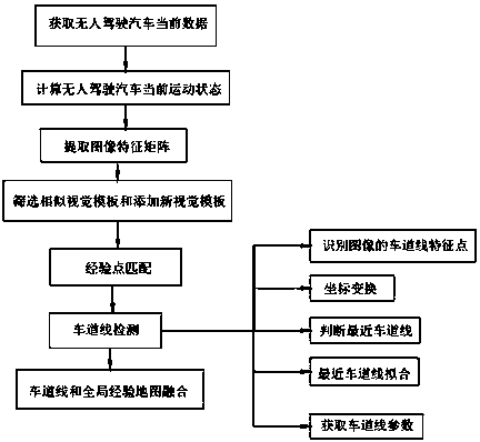
[0043] Refer to Figure 1-2 , The present invention provides a technical solution:

[0044] A road-level global environment map generation method for unmanned driving, such as Figure 1-2 As shown, including the following steps:

[0045] S1. Obtain the current data of the driverless car, and continue to locate and take images during the movement of the driverless car. Record the image number of the current frame as h. According to the coordinates (x h ,y h ) Draw the trajectory of the driverless car and get the global experien...


PUM


Abstract

The invention discloses a road-level global environment map generation method for unmanned driving. The method comprises the steps of acquiring current data of the driverless vehicle, calculating the current motion state of the unmanned driving vehicle, extracting an image feature matrix, screening a similar visual template, adding a new visual template, performing empirical point matching, performing lane line detection, performing lane line and global empirical map fusion and the like to finally generate an unmanned driving road-level global environment map. The unmanned driving car utilizes the vehicle-mounted sensor to sense the surrounding environment of the car. The road, the vehicle position and the obstacle information are obtained through perception; therefore, the aim of unmanned driving is fulfilled; the problem that the traditional method is susceptible to terrain, weather conditions and precision is not accurate enough is solved; according to the road-level global environment map generation method for unmanned driving, environment information is continuously captured in the vehicle driving process to generate a global experience map, and then in combination with multi-lane line detection, the road-level global environment map with high accuracy is obtained.

Description

technical field [0001] The present invention relates to the technical field of unmanned driving, in particular to a method for generating a road-level global environment map for unmanned driving. Background technique [0002] With the vigorous development of communication technology, machine intelligence technology, computer network technology and geographic information system technology, unmanned driving has gained wide attention in many aspects such as military, civilian and scientific research. Interdisciplinary research in many fields, such as electronics, artificial intelligence, etc., has a very broad application prospect. Driverless car is a kind of smart car, which can also be called a wheeled mobile robot. Since the 1970s, developed countries such as the United States, Britain, and Germany have begun to conduct research on driverless cars. Over the years, in the feasibility Significant breakthroughs have been made in terms of practicality and practicality. [0003...

Claims


Application Information

Patent Timeline
IPC IPC(8): G06K9/00
CPCG06V20/588
Inventor 程洪邓桂林杜鹏赵洋
Owner UNIV OF ELECTRONIC SCI & TECH OF CHINA
Why Eureka
Try Eureka