
Candidate road section screening method based on grid segmentation and grid segmentation method

A grid segmentation and road section technology, applied in the field of map matching, can solve the problems of repeated nodes, the inability to accurately know the node index relationship and topology relationship, etc., and achieve the effect of reducing resource waste, increasing application value, and speeding up matching efficiency

Active Publication Date: 2019-09-24
CHANGAN UNIV
View PDF4 Cites 3 Cited by
  • Summary
  • Abstract
  • Description
  • Claims
  • Application Information

AI Technical Summary

Problems solved by technology

[0003] Aiming at the existing problems such as repeated nodes and inability to accurately know the index relationship and topological relationship between nodes in the existing candidate road section screening method, the present invention provides a grid index-based candidate road section screening method, which is specifically implemented by the following technical solutions:

Method used


Image

  • Candidate road section screening method based on grid segmentation and grid segmentation method
  • Candidate road section screening method based on grid segmentation and grid segmentation method
  • Candidate road section screening method based on grid segmentation and grid segmentation method

Examples


Embodiment 1

[0025] A grid segmentation method, comprising the steps of:

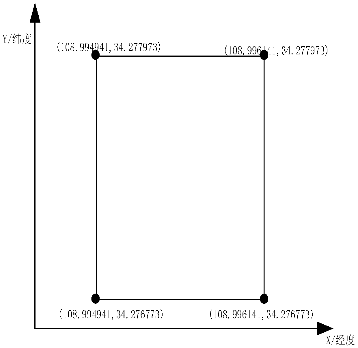
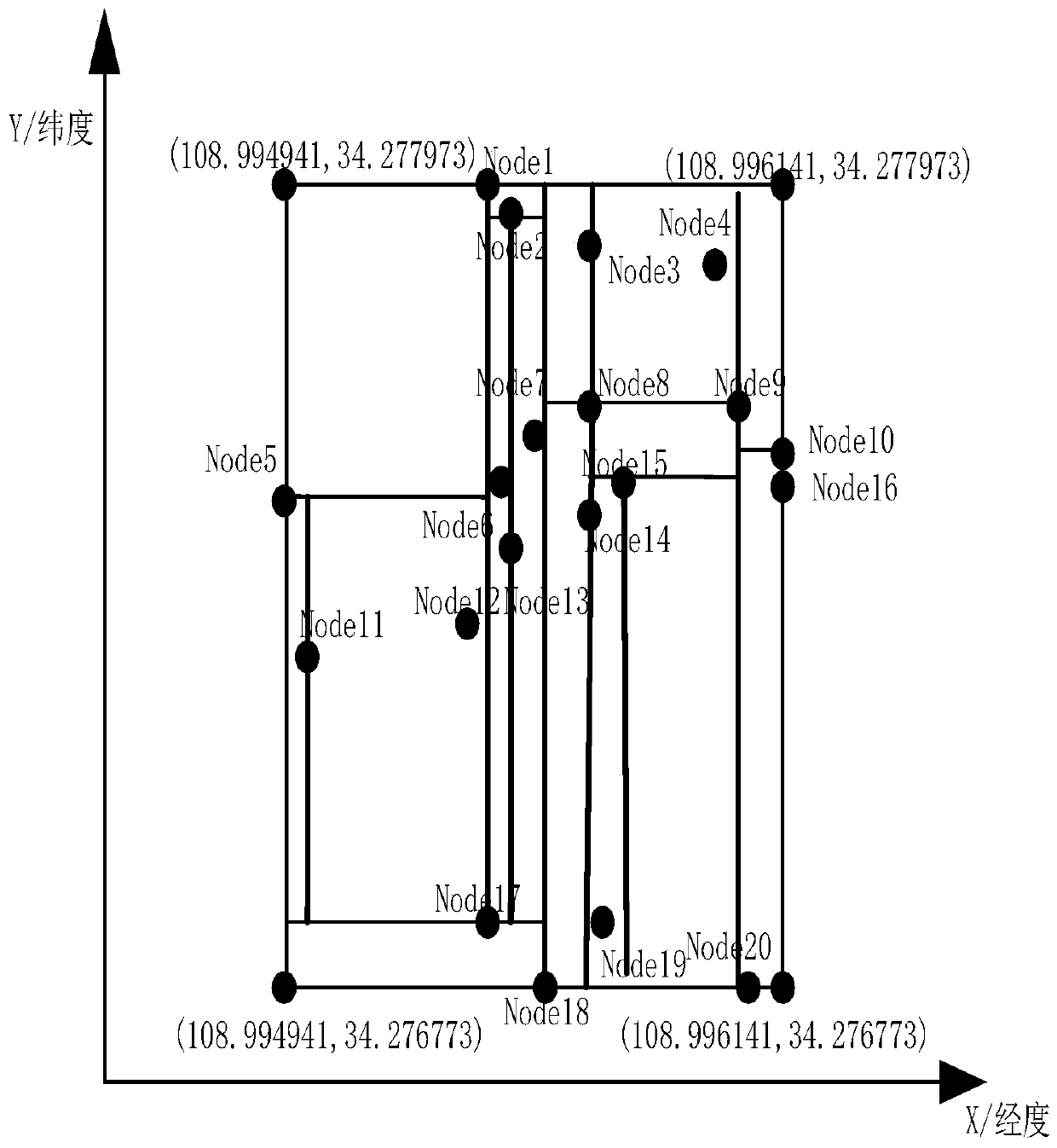
[0026] Step 1: Obtain the road network data in the map, including all road section information in the map and the latitude and longitude coordinate data of nodes contained in each road section, such as figure 1 As shown, the following non-repetitive node latitude and longitude coordinate data node coordinates Node (lon, lat) are stored in the set List, lon is the longitude value, lat is the latitude value, and Node (lon, lat) is stored in the List set, List The collection contains the following node coordinate data:

[0027] Node1(108.995421,34.277973), Node2(108.995528,34.277970),

[0028] Node3(108.995694,34.277963), Node4(108.995784,34.277966),

[0029] Node5(108.994941,34.277561), Node6(108.995424,34.277567),

[0030] Node7(108.995531,34.277571), Node8(108.995694,34.277574),

[0031] Node9(108.995788,34.277574), Node10(108.996141,34.277571),

[0032] Node11(108.994944,34.277444), Node12(108.995415,34.277447...

Embodiment 2

[0061] On the basis of embodiment 1, a method for screening candidate road sections based on grid segmentation is disclosed, comprising the steps of:

[0062] Step 1: Utilize the grid segmentation method as claimed in claim 1 to segment the map containing the candidate road sections to establish a grid, and use the sub-nodes of all levels in order from small to large, and use the same level of sub-nodes as the same level index, and two adjacent The first-level child nodes are used as adjacent two-level indexes to construct the index relationship between the root node and all child nodes;

[0063] Step 2: Obtain the latitude and longitude coordinates (108.995220, 34.277515) of the current GPS track point Z, traverse the index relationship from the root node, find the node closest to the GPS track point Z, and obtain the α nodes closest to the track point Z;

[0064] according to Figure 4 Find the node closest to Z. The traversal process is similar to the split process. Compar...

Embodiment 3

[0074] A grid segmentation method, comprising the steps of:

[0075] Step 1: Obtain the road network data in the map, including all road section information in the map and the node latitude and longitude coordinate data contained in each road section, construct a two-dimensional space coordinate system according to the node latitude and longitude coordinate data, and obtain the maximum value of longitude and latitude in the node coordinates , use the point with the minimum value of latitude and longitude as the lower left point of the grid, and the point with the maximum value of latitude and longitude as the upper right point of the grid to construct the largest grid;

[0076] Step 2: Obtain the latitude average value of the latitude and longitude coordinate data of all nodes, take the node whose latitude value is closest to the latitude average value among all nodes as the root node, use the root node as the split point, and use the latitude value of the root node to linearly...


PUM


Abstract

The invention relates to the field of map matching, and particularly relates to a grid segmentation method. The grid segmentation method comprises the steps: obtaining coordinates of all nodes in road network data, establishing two-dimensional space coordinates according to node coordinates, establishing a maximum grid according to the longitude and latitude ranges of road network data, obtaining nodes closest to the longitude mean values of all the nodes in the grid to serve as root nodes, sequentially selecting a coordinate axis from the root nodes to segment the grid, and forming a grid index starting from the root nodes after segmentation is finished. The invention also relates to a candidate road section screening method based on grid segmentation. The candidate road section screening method comprises the following steps: inquiring the grid index according to the current track point to obtain the node coordinates in the threshold range, and taking the road section corresponding to the node coordinates as the candidate road section of the current GPS track point. Compared with other methods, the candidate road section screening method disclosed by the invention does not need to import the road network data each time, and meanwhile establishes the index and topological relation for the node relation in the road network data, thereby facilitating query and addition and deletion of nodes, reducing the waste of system resources and accelerating the map matching efficiency.

Description

technical field [0001] The invention relates to the field of map matching, in particular to a method for screening candidate road sections based on grid division and a grid division method. Background technique [0002] In the process of map matching, the set of candidate road segments of trajectory points affects the matching efficiency and time complexity. At present, the commonly used methods for screening candidate road sections are to set candidate circle domains for trajectory points or perform grid division. Both methods need to import road network data when calculating the set of candidate road sections for trajectory points. However, due to the large amount of road network data There are duplicate nodes between large and some road sections, and the corresponding topological relationship between nodes cannot be accurately obtained, which greatly limits the screening efficiency of candidate road sections. Contents of the invention [0003] Aiming at the existing pr...

Claims


Application Information

Patent Timeline
IPC IPC(8): G06F16/29G06F16/22
CPCG06F16/29G06F16/2246
Inventor 康军霍明生段宗涛李宜修黄山
Owner CHANGAN UNIV
Learn More