Terrain surface area calculation method based on slope constraint

A technology of surface area and calculation method, which is applied in calculation, image analysis, image enhancement, etc., can solve the problem of ignoring the control effect of topography and landform skeleton, and achieve the effect of improving modeling accuracy

Active Publication Date: 2019-09-27
WUHAN UNIV
View PDF4 Cites 0 Cited by
  • Summary
  • Abstract
  • Description
  • Claims
  • Application Information

AI Technical Summary

Problems solved by technology

With the improvement of remote sensing technology, high-precision elevation data stored in regular grid DEM format has been widely promoted, while the traditional surface area extraction method of re

Method used


Image

  • Terrain surface area calculation method based on slope constraint
  • Terrain surface area calculation method based on slope constraint
  • Terrain surface area calculation method based on slope constraint

Examples


Embodiment Construction

[0033] The present invention will be further described in detail below in conjunction with the accompanying drawings and specific embodiments.

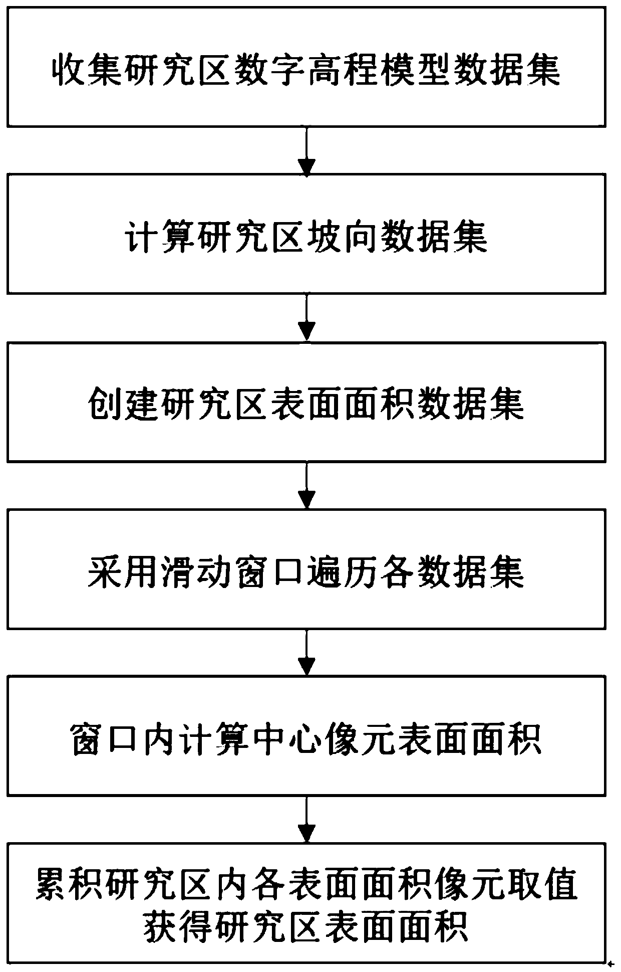
[0034] Taking the Shennongjia forest area as a research, see Figure 1 to Figure 4 , a method for calculating terrain surface area based on slope aspect constraints of the present invention, comprising the following steps:

[0035] Step S1: Collect the digital elevation model data set A of the study area.

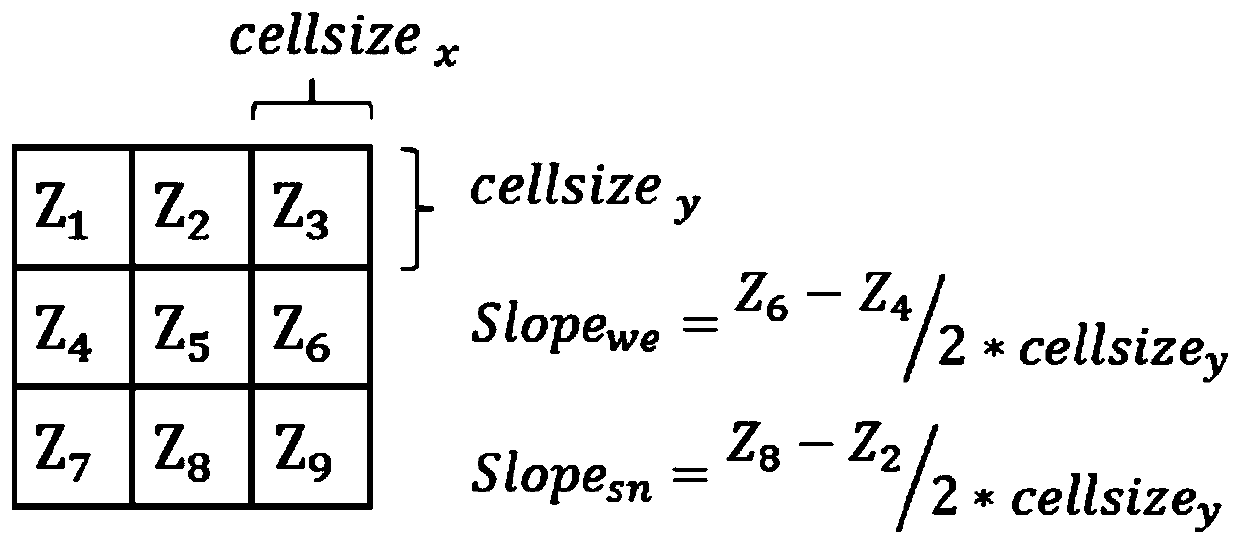
[0036] Step S2: Calculate the slope aspect data set B in the study area according to the digital elevation model data set A obtained in step S1; the slope aspect calculation adopts the quadratic surface fitting method based on numerical integration, let Aspect represent the aspect of the pixel, and Slope sn Indicates the slope of the pixel in the north-south direction, Slope we For the slope in the east-west direction, the calculation formula for the slope and aspect of each cell is:

[0037] Aspect=Slope sn / Slope we .

[00...


PUM


Abstract

The invention provides a terrain surface area calculation method based on slope constraint. In order to the problem that in the prior art, topographic information data cannot be effectively and directly stored, and the skeleton control effect of the topographic elements on the topographic and geomorphological elements are neglected, the method comprises the following steps: extracting topographic and geomorphological elements through topographic analysis, mining topographic and geomorphological information hidden in DEM data, and improving the topographic surface area modeling precision through the assistance of the topographic factors.

Description

technical field [0001] The invention belongs to the technical field of land surface area calculation, and in particular relates to a method for calculating terrain surface area based on slope aspect constraints. Background technique [0002] Topography and landforms are the result of the joint action of the earth's natural processes and human activities, and are one of the most complex phenomena on the earth's surface. Its shape is ever-changing, but it can decompose a series of regular point, line and surface elements. These point, line, and surface elements determine the scale and type of landform, and the extraction of elements through topographic analysis is the basis of topographic analysis. Different internal and external forces acting on topography and landforms will result in obvious differences in the type, scale and scale of the formed topography and landforms; after long-term geographical theory and practical research, it is generally believed that internal force...

Claims


Application Information

Patent Timeline
IPC IPC(8): G06T7/62G01C5/00
CPCG06T7/62G01C5/00G06T2207/30184
Inventor 刘耀林解鹏唐名阳刘艳芳
Owner WUHAN UNIV
Why Eureka
Try Eureka