Airborne laser point cloud classification method based on local and global depth feature embedding

A deep feature and airborne laser technology, applied in the field of point cloud classification, can solve problems such as ignoring context constraints and only considering spatial regularity, so as to optimize marking, refine classification results, and improve robustness

Active Publication Date: 2019-10-22
上海黑塞智能科技有限公司
View PDF8 Cites 2 Cited by
  • Summary
  • Abstract
  • Description
  • Claims
  • Application Information

AI Technical Summary

Problems solved by technology

However, GSR only considers spatial regularity and ignores context constraints

Method used


Image

  • Airborne laser point cloud classification method based on local and global depth feature embedding
  • Airborne laser point cloud classification method based on local and global depth feature embedding
  • Airborne laser point cloud classification method based on local and global depth feature embedding

Examples


Embodiment

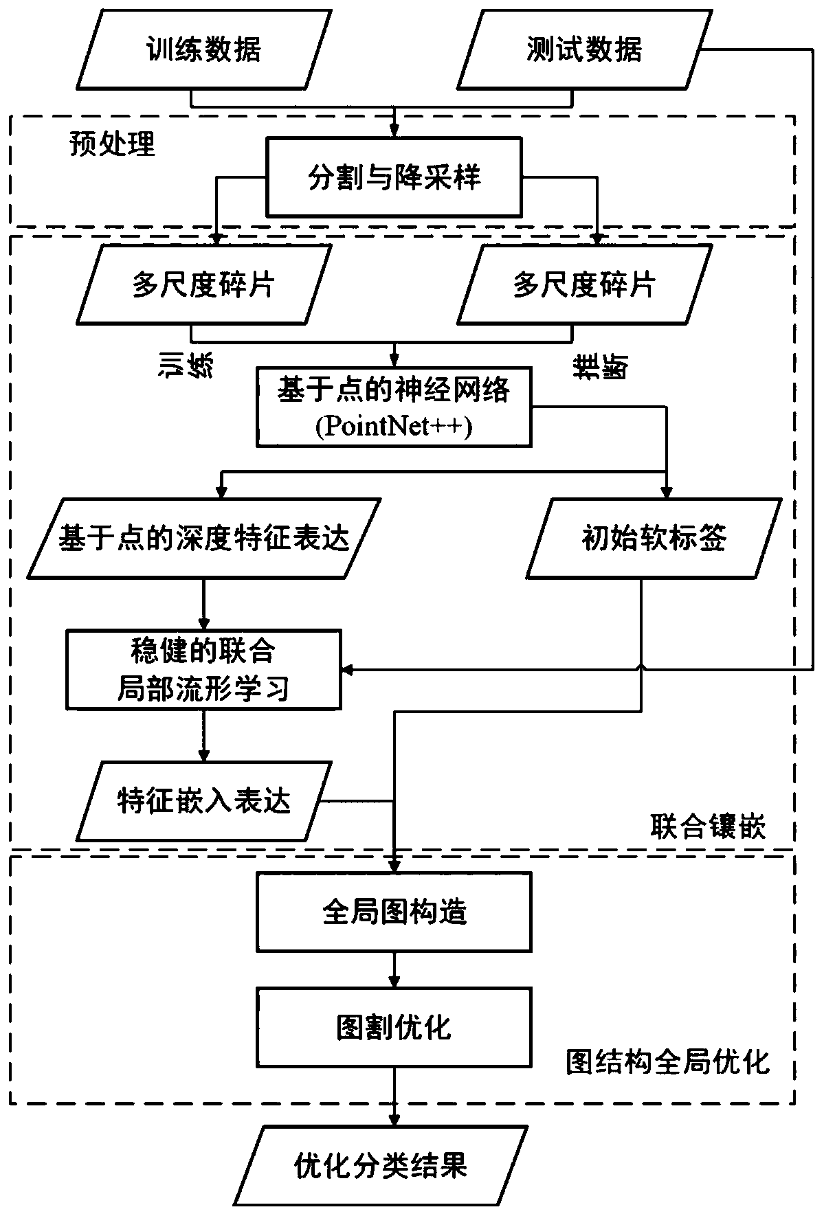
[0050] The proposed point cloud classification method proposed by the present invention includes three main steps, as figure 1 Shown: (1) multi-scale deep feature learning; (2) feature embeddings that preserve local space and feature domain; (3) and graph-based global optimization.

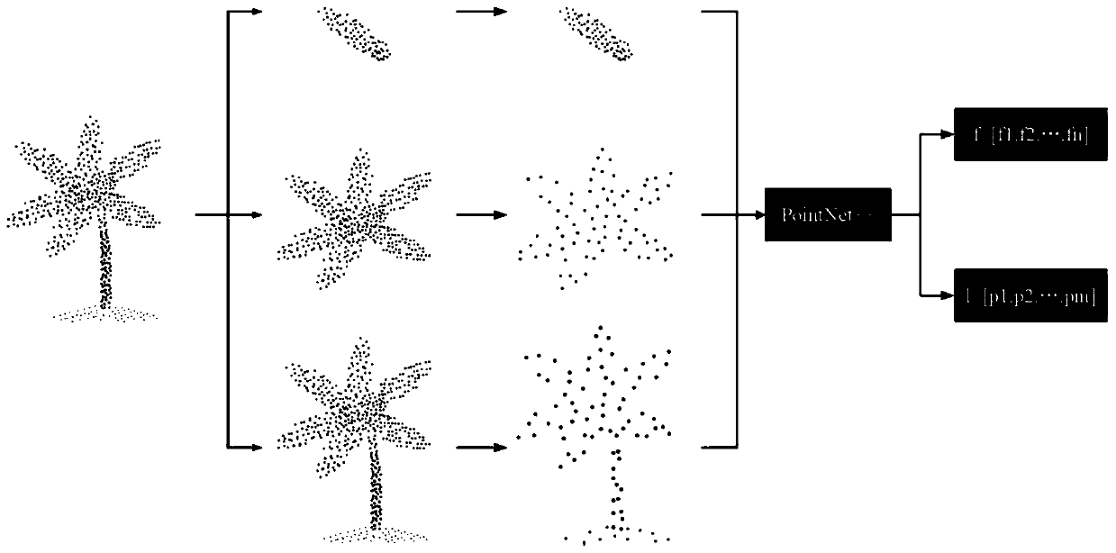
[0051] (1) In the first step, the whole city scene is divided into fragments with different sizes, and these fragments are down-sampled to a fixed number to meet the input requirements of the designed network (such as figure 2 shown). These fragment samples of different scales are then fed into PointNet++ to generate initial classification probabilities, as well as deep features for each point, which include not only point-based features but also regional features for each chip. The scene point cloud segmentation here uses a segmentation method based on a combination of supervoxels and region growth.

[0052] (2) In the second step, to further improve the clarity and spatial correlation of extr...


PUM


Abstract

The invention relates to an airborne laser point cloud classification method based on local and global depth feature embedding. The method comprises the following steps: 1, preprocessing urban scene point cloud data, inputting Point Net++, and obtaining an initial soft label and depth features; 2, embedding the depth features and spatial information in the urban scene point cloud data into an optimization domain, and representing the optimization domain by using a local spatial manifold learning method; and 3, performing classification result optimization on the features based on local data and global feature correlation optimization, which are obtained based on the initial soft label in combination with the optimization domain and are expressed through dimension reduction, by using globalspace regularization to obtain a final point cloud classification result. Compared with the prior art, the method not only optimizes feature learning, but also solves the problem of local and globalmark smoothing, and has the advantages of good optimization effect, high classification accuracy and the like.

Description

technical field [0001] The invention relates to a point cloud classification method, in particular to an airborne laser point cloud classification method based on local and global depth feature embedding. Background technique [0002] 3D point clouds acquired by light detection and ranging (LiDAR) have been widely used in various fields such as 3D urban modeling, land cover and land use mapping, automatic navigation, forestry monitoring, construction monitoring, and historic preservation. Especially for airborne laser scanning (ALS) data, efficient large-scale 3D mapping can be achieved in urban areas. However, as the basis of many of the aforementioned applications, an important task is how to achieve semantic interpretation of 3D scenes presented by point clouds. The main task of semantic interpretation of point clouds is basically to assign a unique semantic label to each point in the point cloud based on the 3D information provided by the point as well as its neighbor p...

Claims


Application Information

Patent Timeline
IPC IPC(8): G06K9/00G06K9/62
CPCG06V20/13G06F18/24147
Inventor 黄荣徐聿升洪丹枫潘玥顾振雄
Owner 上海黑塞智能科技有限公司
Why Eureka
Try Eureka