BIM based sideway construction planning method

A technology for construction access roads and access roads, which is applied in the directions of surveying devices, instruments, surveying and navigation, etc., which can solve problems such as complex earthwork calculations, unintuitive terrain display, and inconvenient slope setting, so as to improve measurement efficiency, facilitate comparison, and avoid rework Effect

Pending Publication Date: 2019-11-05
CCFEB CIVIL ENG
View PDF5 Cites 3 Cited by
  • Summary
  • Abstract
  • Description
  • Claims
  • Application Information

AI Technical Summary

Problems solved by technology

[0003] In view of the above problems, the present invention provides a BIM-based construction access road planning method, which analyzes and compares the access road performance and economic benefits under different access road layout schemes through UAV oblique photography technology, and can screen out better ones. Access road layout plan to save construction costs and shorten construction period, and at the same time solve the problems of unintuitive terrain display, inconvenient slope setting, and complicated earthwork calculation when planning access roads

Method used


Image

  • BIM based sideway construction planning method
  • BIM based sideway construction planning method
  • BIM based sideway construction planning method

Examples


Embodiment

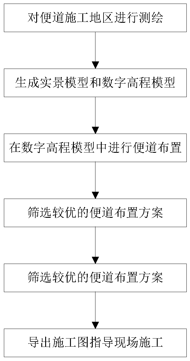
[0029] BIM-based construction access road planning method, see figure 1 , which includes the following steps:

[0030] Step 1. Survey and map the access road construction area. Data collection and mapping through drone tilt photography; that is, by using aerial survey APPs (such as Altizure, Pix4D, Rockycapture) on mobile devices, first plan the data collection range, and set parameters such as the drone route, overlap rate, and tilt angle ( like figure 2 shown), then collect data, and then organize the image data after shooting (such as image 3 UAV oblique photography is to collect images from multiple angles, use professional software to analyze aerial triangulation, geometric correction and other processing, and synthesize high-precision 3D visualization models. Based on this, BIM forward design is more efficient. It conforms to the actual topography, and the surveying and mapping efficiency is higher.

[0031] Step 2, using the surveying and mapping data obtained in ...


PUM


Abstract

The invention discloses a BIM based sideway construction planning method. The method is characterized by comprising the following steps that 1) a sidewalk construction area is plotted; 2) a real-scenemodel and a digital elevation model are generated by using plotting data obtained in the step 1); 3) sideway arrangement is carried out in the digital elevation model based on the real-scene model and digital elevation model generated in the step 2); 4) a preferable sidewalk arrangement scheme is screened; and 5) a working drawing is generated from the digital elevation model of the preferable sidewalk arrangement scheme obtained in the step 4) to guide onsite construction. A unmanned aerial vehicle inclined photographing technology is used to analyze and compare performance and economic returns of the sideway in the different sideway arrangement schemes, the preferable sidewalk arrangement scheme can be screened, the construction cost can be reduced, the construction period is shortened,and the problems including that landform is not displayed in a visualized way, the slope ratio is inconvenient to set, and calculation of cubic meter of earth and stone is complex during constructionsideway planning are overcome.

Description

technical field [0001] The invention belongs to the technical field of highway construction, and in particular relates to a BIM-based construction access road planning method. Background technique [0002] At present, in highway construction, most of them are measured by GPS, total station and other equipment to form a contour topographic map, and CAD drawing is used to plan access roads on a plane. However, the temporary construction design of mountain roads is usually complicated in terrain, which makes surveying and mapping work difficult. The actual geographical environment has great restrictions, and the information such as slope rate cannot be directly displayed in the CAD drawing, which makes the construction of the access road unable to achieve the expected effect. However, the BIM visual design can effectively avoid the occupation of farmland, reduce the excavation of the mountain, and make the road less accessible. The road construction is economical and reasonable...

Claims


Application Information

Patent Timeline
IPC IPC(8): G01C15/00G01C11/02
CPCG01C11/02G01C15/00Y02T10/40
Inventor 周普彭云涌聂海柱谈超康顺刘桥丁晟蒲实李新宇
Owner CCFEB CIVIL ENG
Why Eureka
Try Eureka