Indoor positioning method for assisting in inertial navigation array based on map information

An indoor positioning and map information technology, applied in navigation, surveying and navigation, navigation through speed/acceleration measurement, etc., can solve the problems of high manpower and equipment costs, low positioning reliability, and difficulty in realizing it, so as to improve positioning accuracy and reliability, and the effect of reducing positioning costs

Active Publication Date: 2019-11-08
UNIV OF SHANGHAI FOR SCI & TECH
View PDF8 Cites 3 Cited by
  • Summary
  • Abstract
  • Description
  • Claims
  • Application Information

AI Technical Summary

Problems solved by technology

[0003] At present, there are many indoor positioning technologies developed: the indoor positioning method based on Wifi-Fingerprint, this method not only requires sufficient wireless access points in the positioning environment, At the same time, it is also necessary to manually collect a large amount of training data and establish a fingerprint database. This method has high manpower and equipment costs.
In addition, some indoor positioning methods are based on infrared, ultrasonic, Bluetooth, UWB positioning technology, ZigBee technology; the above positioning methods mainly rely on related infrastructure, the advantage is high positioning accuracy, the disadvantage is high cost, and can be transplanted Sex is also very low
Positioning cannot be achieved if the positioning environment lacks relevant infrastructure
[0004] Chinese patent document CN106295512A discloses a multi-correction line indoor vision database construction method and an indoor positioning method based on signs. It is difficult to achieve positioning and navigation in the real indoor environment. A series of image sets with the same logo need to be arranged indoors, and the indoor environment needs to be changed.
Chinese patent document CN106228538A discloses a logo-based binocular vision indoor positioning method. The positioning process requires dual cameras to obtain images, and uses the cameras to locate the target point, which involves the calibration of the internal and external parameters of the cameras, as well as the camera coordinate system and image coordinates. The conversion between the coordinate system and the world coordinate system is generally used in the field of three-dimensional positioning of mobile robots, but it is difficult to popularize and apply it to the general public.
In short, the existing single visual positioning method technology is not suitable for indoor positioning
[0005]At present, the use of inertial navigation positioning has become an important method to obtain the position of personnel waiting for detection objects in indoor tasks. At the same time, inertial navigation positioning also has certain shortcomings. Affected by processing technology and installation factors, there are measurement errors, which will accumulate with the increase of positioning time, resulting in a decrease in the positioning accuracy and positioning reliability of the detected object
Therefore, the existing inertial navigation positioning methods and devices cannot meet the requirements of indoor positioning

Method used


Image

  • Indoor positioning method for assisting in inertial navigation array based on map information
  • Indoor positioning method for assisting in inertial navigation array based on map information
  • Indoor positioning method for assisting in inertial navigation array based on map information

Examples


Embodiment Construction

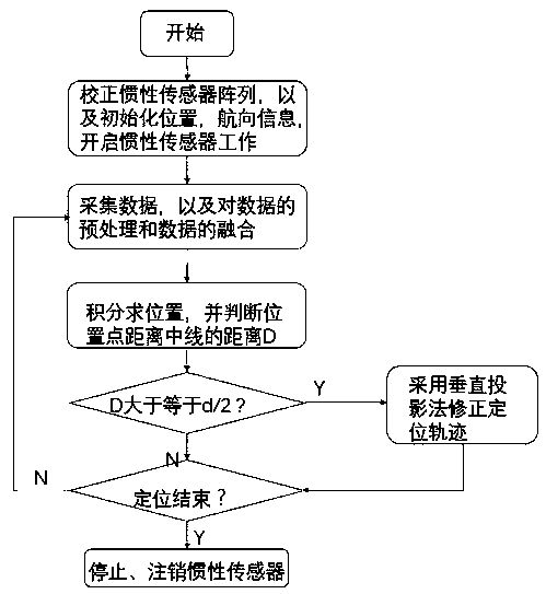
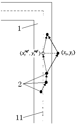
[0035] Example figure 1 As shown, the indoor positioning method of the present invention based on map information assisted inertial navigation array includes the following steps:

[0036] Step 1. Perform initial correction to the inertial sensor array, and correct the non-orthogonality of the inertial sensor sensitive axes under the initial conditions of the inertial navigation array;

[0037] Step 2. Establish the inertial sensor accelerometer model and fuse the accelerometer value. The accelerometer model is defined as:

[0038] y=a+b d +b v +v (1)

[0039] Among them, y is the measured acceleration value, a is the real acceleration value, b d is the deterministic bias error, b v is the random drift deviation, v is the measurement white noise that causes the rate random walk error, the rate random walk error is the high-frequency noise detected in a short time after the rate signal measured by the inertial sensor is integrated, and the short time is ignored In the offs...


PUM


Abstract

The invention discloses an indoor positioning method for assisting in an inertial navigation array based on map information. According to the method, carrying out initial correction on an inertial sensor array and correcting non-orthogonality of a sensitive axis of the inertial sensor under the initial condition of the inertial navigation array; establishing an inertial sensor accelerometer modeland fusing an accelerometer value; on the basis of a minimum mean square error algorithm, carrying out fusion of the accelerometer data in the inertial array and removing abnormal data; carrying out double integral processing on the accelerometer data and performing a trapezoidal method to obtain first-order approximation of sampled data so as to obtain position information of an indoor target; and then carrying out constrain correction on a movement track by introducing map information to obtain final position information of the indoor target. With the disclosed method, defects of the traditional indoor positioning are overcome; with the low-cost navigation device and the map information, the positioning of the indoor target and correction of the positioning trajectory are realized, so that the positioning accuracy and reliability are improved and the positioning cost is lowered.

Description

technical field [0001] The invention relates to an indoor positioning method based on map information assisted inertial navigation array. Background technique [0002] Indoor positioning refers to the realization of position positioning in the indoor environment. It mainly adopts the indoor position positioning system formed by the integration of various technologies such as wireless communication, base station positioning, and inertial navigation positioning, so as to realize the position monitoring of people and objects in the indoor space. Due to the complex and changeable indoor environment and the inability to receive satellite positioning signals, there are certain difficulties in indoor positioning at present. When satellite positioning cannot be used in the indoor environment, indoor positioning technology is used as an auxiliary positioning of satellite positioning to solve the problem that the satellite signal is weak when it reaches the ground and cannot penetrate...

Claims


Application Information

Patent Timeline
Patent Type & Authority Applications(China)
IPC IPC(8): G01C21/16G01C21/00G01C25/00
CPCG01C21/16G01C21/005G01C25/005Y02D30/70
Inventor 范亚州王创王远
Owner UNIV OF SHANGHAI FOR SCI & TECH
Why Eureka
Try Eureka