Geological disaster station based on Beidou satellite high-precision monitoring and control system

A technology of geological disasters and Beidou satellites, applied in satellite radio beacon positioning systems, radio wave measurement systems, measuring devices, etc., can solve the problem of inability to automatically realize remote real-time monitoring and early warning of geological disasters, inconvenient large-scale node layout, Unable to guarantee the depth of data collection and other issues, to achieve the effect of easy portability and installation, simple structure and low manufacturing cost

Inactive Publication Date: 2019-11-29
ANHUI TELECOMM ENG
View PDF5 Cites 7 Cited by
  • Summary
  • Abstract
  • Description
  • Claims
  • Application Information

AI Technical Summary

Problems solved by technology

[0004] The environmental sensing information of the traditional geological disaster monitoring and early warning system is usually transmitted by wire. However, the geographical adjustment in mountainous areas is complicated, and the line erection is difficult. Deep, can not provide a huge amount of data basis for the r

Method used


Image

  • Geological disaster station based on Beidou satellite high-precision monitoring and control system
  • Geological disaster station based on Beidou satellite high-precision monitoring and control system
  • Geological disaster station based on Beidou satellite high-precision monitoring and control system

Examples


Embodiment 1

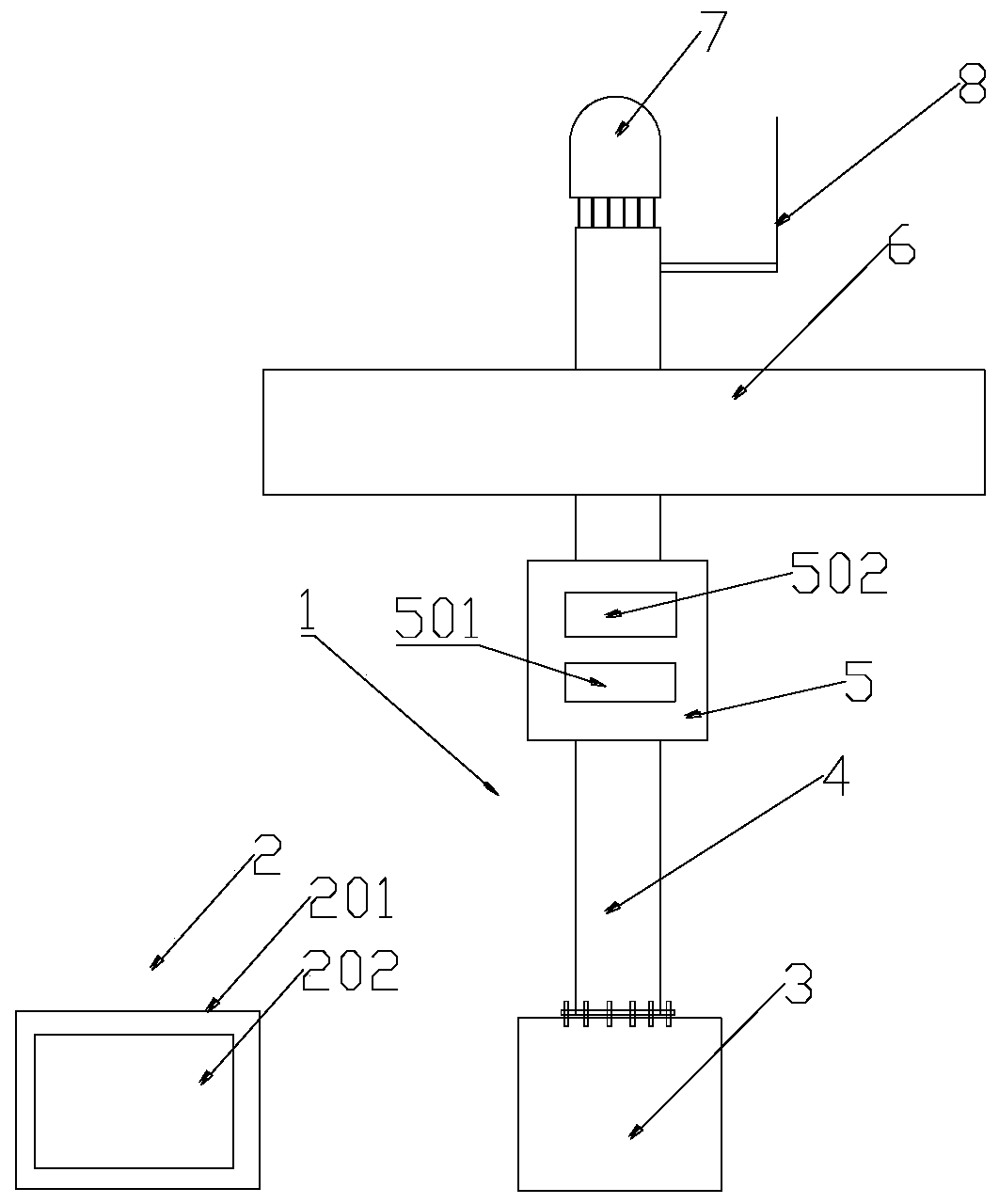
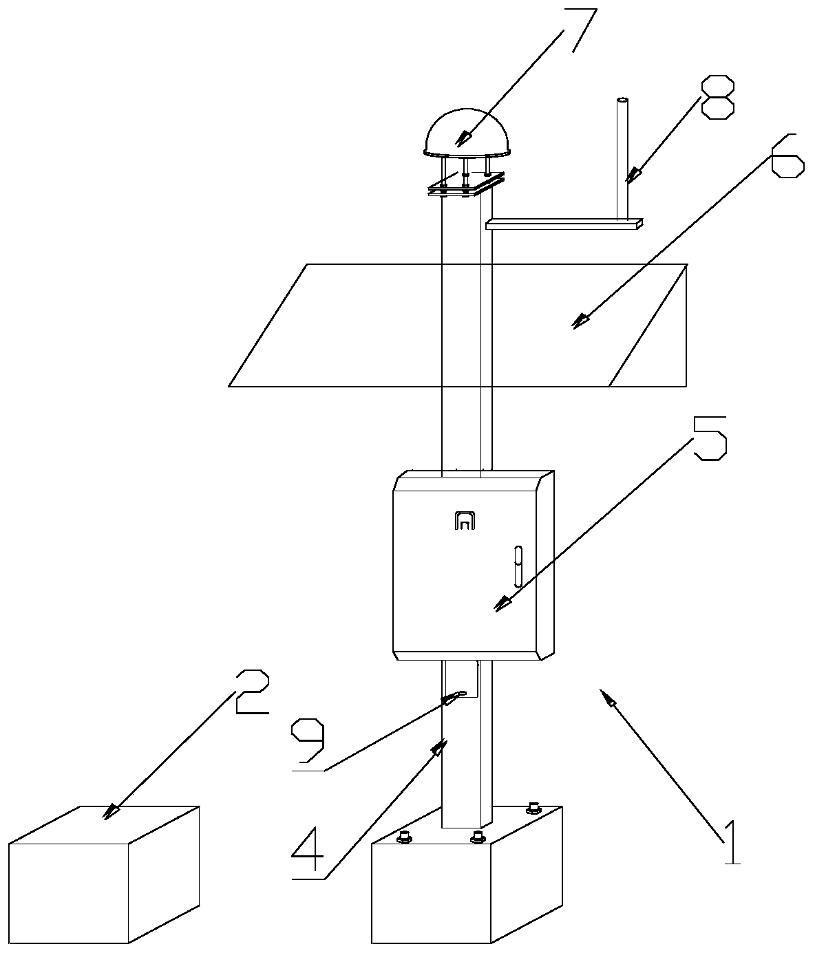
[0038] like Figure 1-2 Shown in this embodiment is a geohazard site based on high-precision monitoring of Beidou satellites. The monitoring body 1 and the buried box 2 are matched with each other. The monitoring body 1 includes a base 3, and a pillar is detachably connected to the base 3 4. A control module 5 is detachably connected to the middle side of the pillar 4, and the control module 5 includes a controller module 501 and a data transmission module 502. The upper side of the pillar 4 is detachably connected to a solar panel 6, and the pillar 4 The top is detachably connected with a satellite receiving antenna 7;

[0039] The monitoring body 1 also includes a data acquisition module, and the data acquisition module includes a rain gauge, a video acquisition device, an air temperature and humidity sensor, a soil moisture sensor, and an osmometer, and the rain gauge, the soil moisture sensor, and the osmometer, respectively The video data of rainfall, soil moisture, pressu...

Embodiment 2

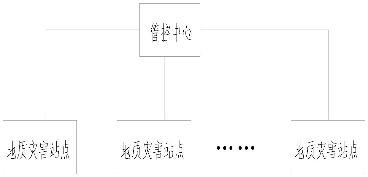
[0047] like image 3 As shown, this embodiment provides a geological disaster management and control system based on Beidou satellite high-precision monitoring, including a management and control center, and several geological disaster sites as described in Embodiment 1;

[0048] The geological disaster sites are randomly deployed in the set geological disaster monitoring area, and several geological disaster sites form a data acquisition network for sensing and collecting environmental sensing information in the monitoring area through the self-organizing network of data transmission modules. The collected data information is transmitted to the control center for centralized processing, storage and display;

[0049] The management and control center includes a data processing module, a decision-making assistance module, a human-computer interaction module and a display and alarm module;

[0050] The data processing module is used to calculate the received data information, o...


PUM


Abstract

The invention relates to the technical field of geological equipment, and discloses a geological disaster station based on Beidou satellite high-precision monitoring and a control system. The stationcomprises a monitoring body and a buried box that are matched, wherein the system comprises a control center and a plurality of geological disaster stations. The geological disaster station can warn dangers in advance, can get displacement information of sliding mass in real time so as to predict and prevent sliding disaster, and achieves effects of early warning and self-control, thereby having high practical value and bright application prospect.

Description

technical field [0001] The invention relates to the technical field of geological equipment, in particular to a geological disaster site and a management and control system based on Beidou satellite high-precision monitoring. Background technique [0002] Landslide geological hazards mainly refer to collapse (ie dangerous rock mass), landslide, mud-rock flow, karst land subsidence and ground fissure, etc. They are produced by the relatively recognized drastic changes in the geological structure of the original crustal surface, and are generally considered to be sudden. [0003] The occurrence of landslides can be divided into three stages: creep deformation stage, landslide failure stage and gradual stabilization stage. In the stage of creep deformation, a certain part inside the slope deforms first because the shear strength is lower than the shear force, resulting in slight movement; the deformation develops further until intermittent tension cracks appear on the slope su...

Claims


Application Information

Patent Timeline
IPC IPC(8): G08B21/10G08B25/00G01D21/02G01S19/14
CPCG01D21/02G01S19/14G08B21/10G08B25/00
Inventor 夏波张军吴大海钱超
Owner ANHUI TELECOMM ENG
Why Eureka
Try Eureka