SAR image glacier recognition method based on texture feature assistance

A technology of texture features and identification methods, applied in the field of remote sensing geoscience applications, can solve problems such as large influence, and achieve the effects of good classification effect, simple and easy execution steps, and simple data acquisition.

Active Publication Date: 2019-12-03
NANJING UNIV
View PDF3 Cites 7 Cited by
  • Summary
  • Abstract
  • Description
  • Claims
  • Application Information

AI Technical Summary

Problems solved by technology

However, since there is a layer of debris mixture on the surface of moraine-covered glaciers, which have similar spectral information to the rocks around the glacier in optical images, optical remote sensing identification methods such as band ratio method and normalized snow cover index can only identify relatively clean The pure glacier in the area, and the optical remote sensing is greatly affected by the weather conditions, so it is difficult to observe the same area at the same time

Method used


Image

  • SAR image glacier recognition method based on texture feature assistance
  • SAR image glacier recognition method based on texture feature assistance
  • SAR image glacier recognition method based on texture feature assistance

Examples


Embodiment Construction

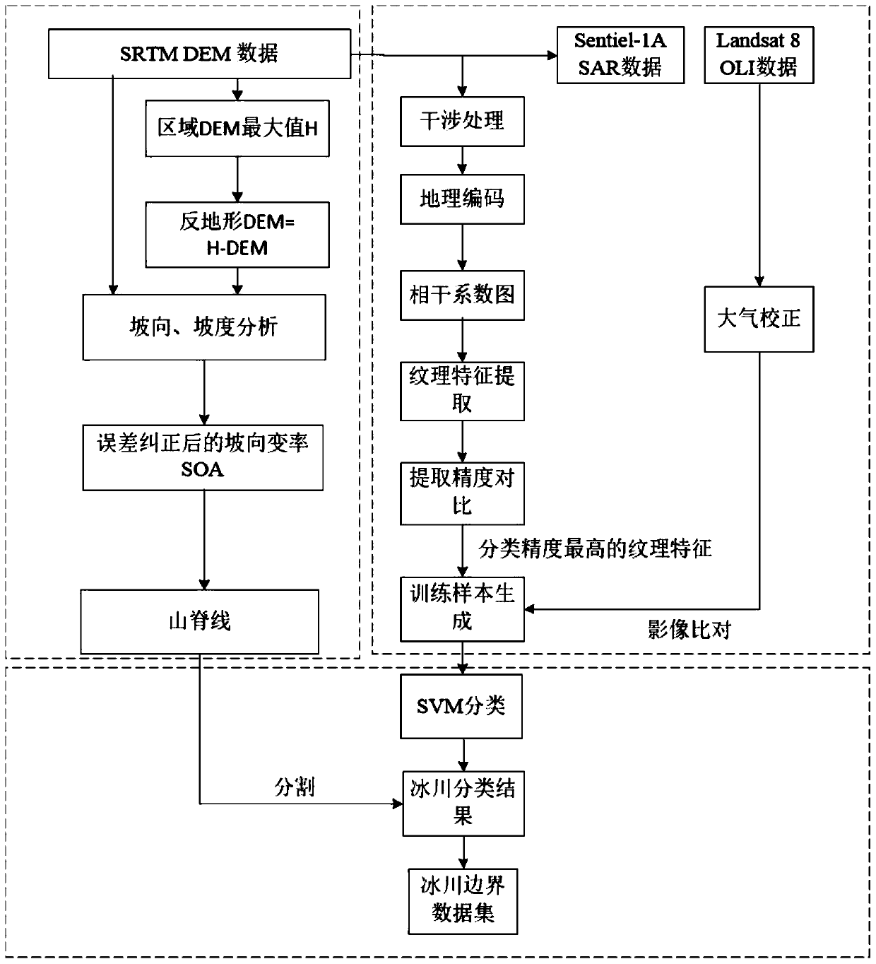
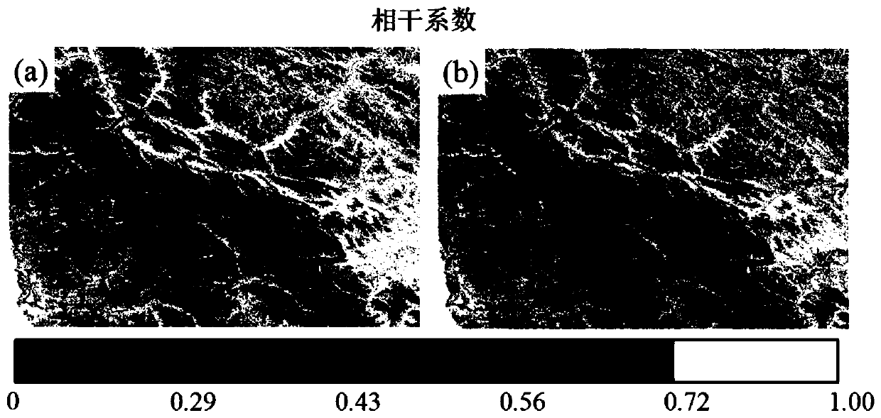
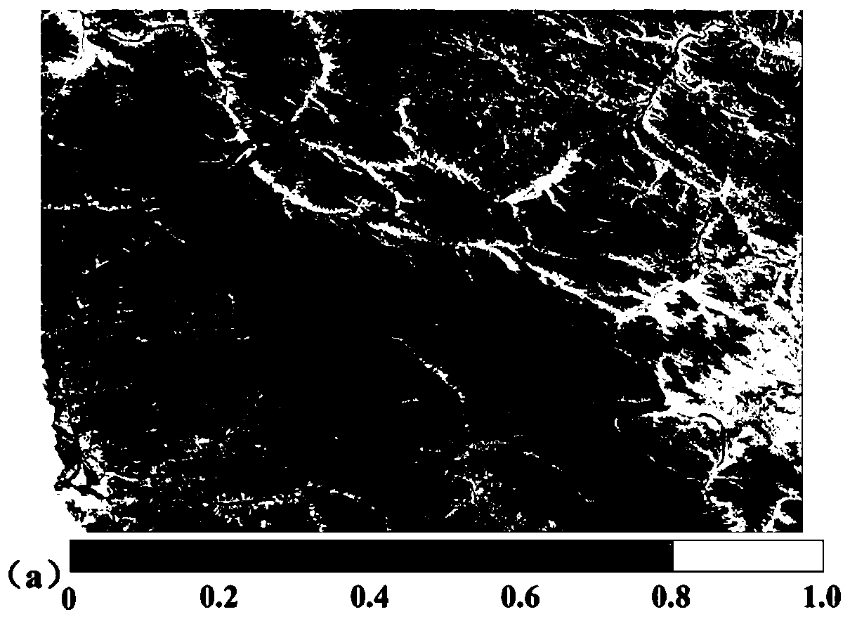
[0030] The present invention will be further described below in conjunction with the accompanying drawings. Make the technical route and operation steps of the present invention clearer. The example study area of ​​the present invention selects the upper reaches of the Keleqing River (35.1°N-36.2°N, 76.3°E-77.9°E) in the Karakoram Mountains, and the Sentinel-1A data used are September 11 and September 2018 The SLC data of the two scenes on the 23rd, the time base is 12 days. Landsat8 OLI data was acquired on August 29, 2018. DEM data is SRTM Version4 data.

[0031] Such as figure 1 As shown, it is a flow chart of the SAR image glacier recognition method based on texture feature assistance in this embodiment, and the specific steps are as follows:

[0032] The first step is to prepare remote sensing image data and digital elevation model (DEM) data.

[0033] Step 1a, download the Sentinel-1A SLC data that the time interval of two scenes in a certain area is 12 days, both h...


PUM


Abstract

The invention relates to an SAR (Synthetic Aperture Radar) image glacier recognition method based on texture feature assistance, which is used for recognizing a glacier by utilizing an interference measurement method of Sentinel-1A data and combining texture information. The method comprises the following steps: utilizing Sentinel-1A data to carry out interference processing to obtain a coherencecoefficient graph; extracting seven textural features of mean value, variance, homogeneity, contrast, dissimilarity, entropy and correlation of the coherence coefficient graph; and comparing glacier extraction effects among different texture feature combinations. And selecting four textural features of mean value, variance, homogeneity and dissimilarity under the VV polarization mode with the highest classification precision, and training by utilizing an SVM classifier to obtain classes of glaciers, rocks, accumulated snow and the like. And converting the classified data into a shape format, and segmenting the data through ridge lines to obtain a glacier boundary data set. Compared with a traditional threshold segmentation method based on a coherence coefficient graph, texture features areintroduced, and glacier recognition is more accurate.

Description

technical field [0001] The invention relates to a SAR image glacier recognition method based on texture features, and belongs to the technical field of remote sensing geoscience applications. Background technique [0002] Glacier resources are important freshwater resources on the earth. As an important indicator of global climate change, glacier identification using remote sensing methods is of great significance for monitoring glacier area and its reserves, and studying global climate change. However, since there is a layer of debris mixture on the surface of moraine-covered glaciers, which have similar spectral information to the rocks around the glacier in optical images, optical remote sensing identification methods such as band ratio method and normalized snow cover index can only identify relatively clean The pure glacier in the area, and the optical remote sensing is greatly affected by the weather conditions, so it is difficult to observe the same area at the same t...

Claims


Application Information

Patent Timeline
Patent Type & Authority Applications(China)
IPC IPC(8): G06K9/00G06K9/62G06T7/33G06T7/45
CPCG06T7/337G06T7/45G06V20/13G06F18/2411
Inventor 柯长青范宇宾郭唯娜姚国慧
Owner NANJING UNIV
Why Eureka
Try Eureka