RTK/UWB combined mapping method and system for satellite signal shielding area

A satellite signal and mapping method technology, which is applied in satellite radio beacon positioning system, radio wave measurement system, measuring device, etc., can solve the problems of high efficiency and high-precision mapping in satellite signal shading areas, and achieve automation High degree, easy practice, simple operation effect

Inactive Publication Date: 2019-12-10
BEIJING UNIVERSITY OF CIVIL ENGINEERING AND ARCHITECTURE
View PDF10 Cites 4 Cited by
  • Summary
  • Abstract
  • Description
  • Claims
  • Application Information

AI Technical Summary

Problems solved by technology

[0005] The embodiment of the present invention provides an RTK/UWB combined mapping method and system for satellite signal shadowed areas, which is used to solve the problem that high-

Method used


Image

  • RTK/UWB combined mapping method and system for satellite signal shielding area
  • RTK/UWB combined mapping method and system for satellite signal shielding area
  • RTK/UWB combined mapping method and system for satellite signal shielding area

Examples


Embodiment Construction

[0046] In order to make the purposes, technical solutions and advantages of the embodiments of the present invention clearer, the technical solutions in the embodiments of the present invention will be clearly and completely described below with reference to the accompanying drawings in the embodiments of the present invention. Obviously, the described embodiments These are some embodiments of the present invention, but not all embodiments. Based on the embodiments of the present invention, all other embodiments obtained by those of ordinary skill in the art without creative efforts shall fall within the protection scope of the present invention.

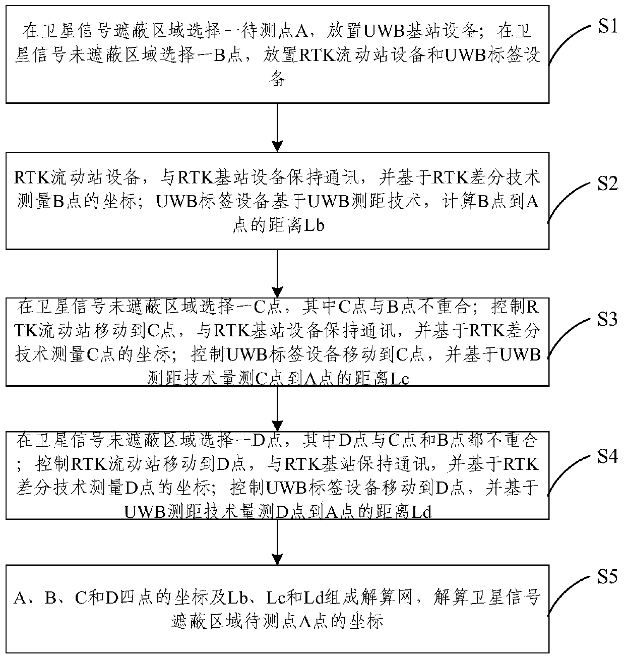
[0047] In order to solve at least one technical problem in the prior art, an RTK / UWB combined mapping method for satellite signal shadowed areas is provided. like figure 1 As shown, the RTK / UWB combined mapping method for the satellite signal shadowed area generally includes the following steps.

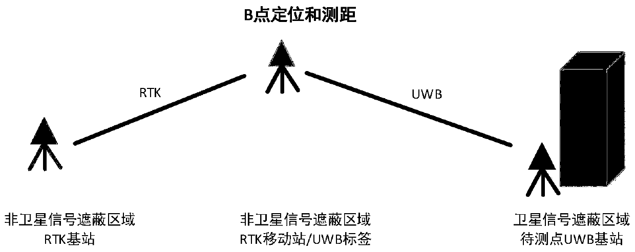
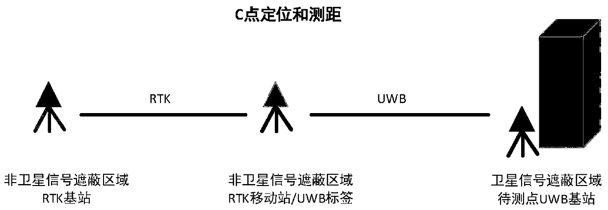
[0048] Step S1, select a point A ...


PUM


Abstract

The embodiment of the invention provides an RTK/UWB combined mapping method and system for a satellite signal shielding area. According to the method, high-precision coordinates can be measured by using an RTK positioning mode; for the satellite signal shielding area, point position coordinates of three or more non-satellite signal shielding areas can be obtained by utilizing an RTK technology; then, the distances from RTK positioning points to to-be-solved points in a satellite signal shielding area are measured through the UWB distance measuring technology, and according to the coordinates of the RTK positioning points and UWB distance measuring information, networking can be conducted to solve the coordinates of the to-be-solved points (more than three RTK point position time adjustmentsolving coordinates); the embodiment of the invention has the advantages that the RTK mapping problem of the satellite signal shielding area is solved, the mapping precision is high, the operation efficiency is obviously superior to that of other methods, and meanwhile, the method is easy to practice, simple to operate and relatively high in automation degree.

Description

technical field [0001] The invention relates to the technical field of digital mapping, in particular to an RTK / UWB combined mapping method and system for satellite signal shadowed areas. Background technique [0002] Real-time dynamic (Real-time kinematic, RTK) carrier phase difference technology is a commonly used satellite positioning real-time mapping method. Set up base stations in open areas to collect carrier phase data for real-time calculation and send them to the rover receiver for differential analysis. Rover coordinates for outdoor real-time mapping. RTK outdoor real-time mapping can achieve centimeter-level mapping accuracy, real-time and rapidity greatly improve the efficiency of mapping operations. Because RTK technology is a technology of satellite positioning, it needs to receive satellite signals to achieve positioning. Therefore, the positioning accuracy is affected by the number of observation satellites. For sheltered areas (such as the corners of urban...

Claims


Application Information

Patent Timeline
IPC IPC(8): G01S19/43G01S11/02
CPCG01S11/02G01S19/43
Inventor 韩厚增杨燈王坚
Owner BEIJING UNIVERSITY OF CIVIL ENGINEERING AND ARCHITECTURE
Why Eureka
Try Eureka