Passive positioning method of employing cooperative short wave and satellite system for over-the-horizon target

A satellite system and passive positioning technology, applied in radio wave measurement systems, positioning, measurement devices, etc., can solve the problem of limited positioning accuracy of over-the-horizon targets, and achieve improved target positioning accuracy, reliable performance, and efficient computing. Effect

Active Publication Date: 2019-12-13
PLA STRATEGIC SUPPORT FORCE INFORMATION ENG UNIV PLA SSF IEU
View PDF7 Cites 7 Cited by
  • Summary
  • Abstract
  • Description
  • Claims
  • Application Information

AI Technical Summary

Problems solved by technology

[0006] Aiming at the problem of limited positioning accuracy of over-the-horizon targets, the present invention provides a passive over-the-horizon target positioning method for cooperative short-wave and satellite systems, so as to improve the positioning performance of over-the-horizon targets under the condition of large observation noise

Method used


Image

  • Passive positioning method of employing cooperative short wave and satellite system for over-the-horizon target
  • Passive positioning method of employing cooperative short wave and satellite system for over-the-horizon target
  • Passive positioning method of employing cooperative short wave and satellite system for over-the-horizon target

Examples


Embodiment Construction

[0053] The present invention will be further explained below in conjunction with accompanying drawing and specific embodiment:

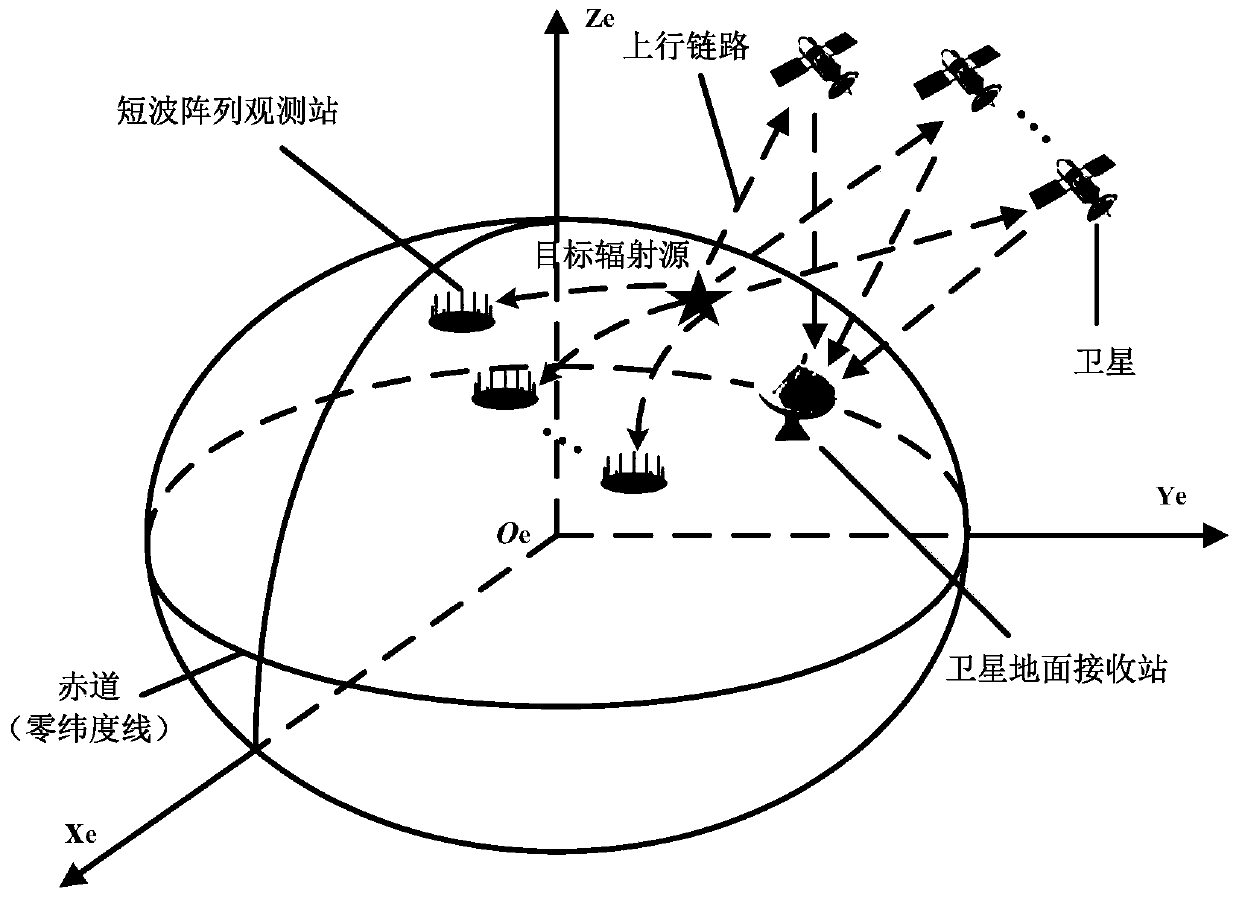
[0054] Such as figure 1 As shown, a kind of cooperative short-wave and satellite system passive positioning method for over-the-horizon targets disclosed by the present invention requires that each short-wave observation station be installed with an antenna array, and the satellite ground observation station is required to receive target radiation signals of multiple links at the same time , the earth-centered earth-fixed coordinate parameters of the over-the-horizon target are estimated by combining the azimuth angle of the target arriving at multiple short-wave observation stations and the time difference observations of multiple satellite uplinks.

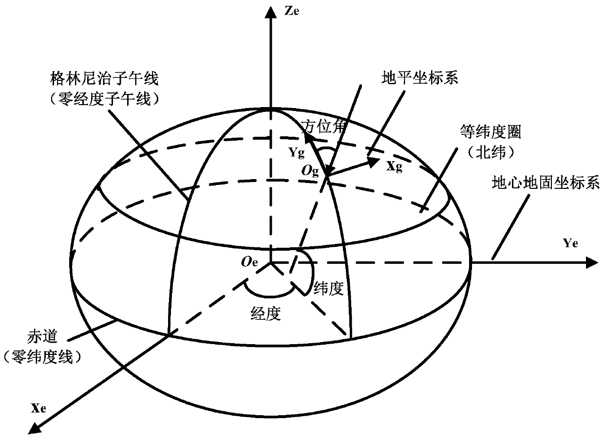
[0055] Such as figure 2 As shown, the present invention utilizes the hidden relationship between the earth's geographic coordinates, the earth-centered earth-fixed coordinates and the azimuth angles ...


PUM


Abstract

The invention discloses a passive positioning method of employing cooperative short wave and satellite system for an over-the-horizon target. The method comprises the steps of establishing pseudo-linear observation equations about a plurality of satellite uplink time difference parameters by using an auxiliary variable; establishing a mathematic relation of various short wave observation station arrival azimuths about horizontal coordinate parameters of a target on various stations on the basis of local horizontal coordinate systems of various short wave observation stations, and establishingpseudo-linear observation equations based on a plurality of short wave observation station azimuth parameters by using conversion of the coordinate parameters of the target in horizontal coordinate systems of various stations and earth-centered earth-fixed coordinate parameters; establishing a global least squares optimization model in a quadratic constraint condition by combining the pseudo-linear observation equations of the plurality of satellite uplink time difference parameters with the pseudo-linear observation equations of the plurality of short wave observation station azimuth parameters and combining earth ellipsoid constraints; and designing an augmented Lagrange multiplier algorithm to achieve accurate positioning of the ground over-the-horizon target. According to the passive positioning method, two positioning mechanisms can be cooperatively utilized effectively, so that the positioning accuracy on the target is significantly improved.

Description

technical field [0001] The invention belongs to the technical field of radio signal positioning, and in particular provides a passive positioning method for over-the-horizon targets of a cooperative short-wave and satellite system for the over-the-horizon ground target positioning scene of a combined short-wave and satellite communication system. Background technique [0002] As we all know, radio signal positioning technology is very important for target discovery and situation awareness. After decades of development, this technology has made great progress in theory and engineering applications. According to the positioning means, radiolocation can be divided into satellite-based radiolocation and land-based radiolocation. Satellite-based radio positioning system, that is, satellite navigation and positioning system has a wide range of high-precision positioning, speed measurement and the ability to provide timing services, and has been widely used in various fields of nat...

Claims


Application Information

Patent Timeline
Patent Type & Authority Applications(China)
IPC IPC(8): G01S5/14G01S5/10
CPCG01S5/145G01S5/10
Inventor 尹洁昕王鼎唐涛杨红霞王成魏帅吴志东李建兵张光伟韩博臣
Owner PLA STRATEGIC SUPPORT FORCE INFORMATION ENG UNIV PLA SSF IEU
Why Eureka
Try Eureka