Three-dimensional imaging method and system of landslide body

A three-dimensional imaging, landslide mass technology, applied in radio wave measurement system, electric/magnetic exploration, sound wave re-radiation, etc. Imaging accuracy, reducing data errors and data information loss, and the effect of accurate and reliable prior conditions

Active Publication Date: 2020-02-21
SHANDONG UNIV
View PDF7 Cites 13 Cited by
  • Summary
  • Abstract
  • Description
  • Claims
  • Application Information

AI Technical Summary

Problems solved by technology

[0003] At present, only one method is often used for landslide surveys, so that the obtained survey data is inaccurate, and the 3D imaging maps obtained are also inaccurate, which affects the disaster management in th

Method used


Image

  • Three-dimensional imaging method and system of landslide body
  • Three-dimensional imaging method and system of landslide body

Examples


Embodiment 1

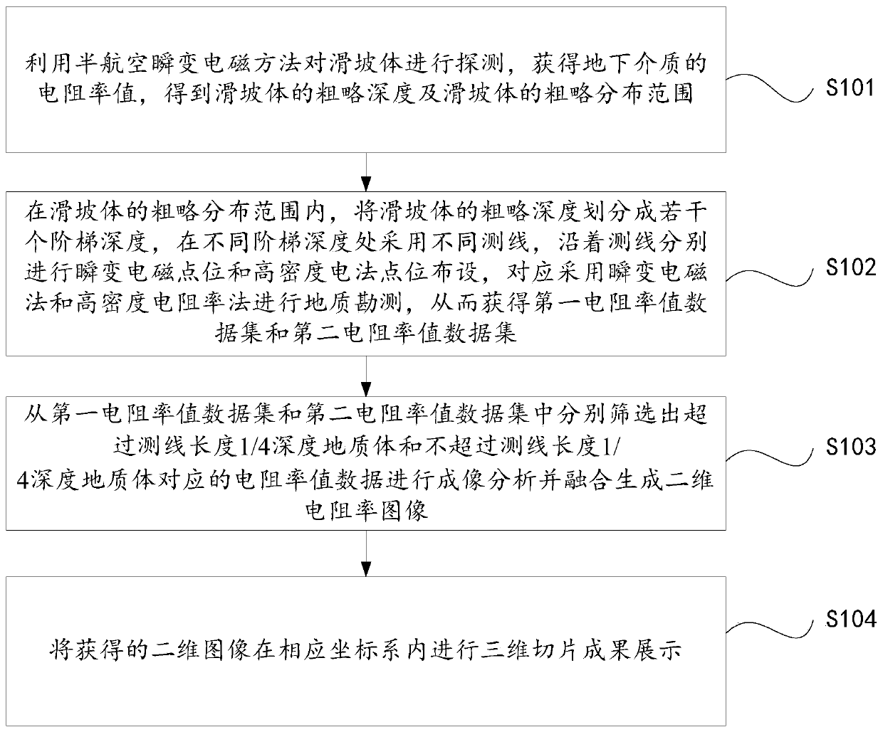
[0025] Such as figure 1 As shown, the three-dimensional imaging method of a kind of landslide body of the present embodiment comprises:

[0026] S101: Use the semi-aerial transient electromagnetic method to detect the landslide body, obtain the resistivity value of the underground medium, and obtain the rough depth of the landslide body and the rough distribution range of the landslide body;

[0027] The semi-aerial transient electromagnetic method is a new design scheme of the aeronautical electromagnetic method. It adopts the working mode of ground emission and air reception. The emission source can be a loop source or an electrical source. It can be a single source or It is a multi-source, by arranging a large-scale, high-intensity and relatively stable emission source on the ground to excite the transient electromagnetic field, and realizing the signal reception in response to the secondary eddy current field in the air, after processing and interpretation, it realizes the...

Embodiment 2

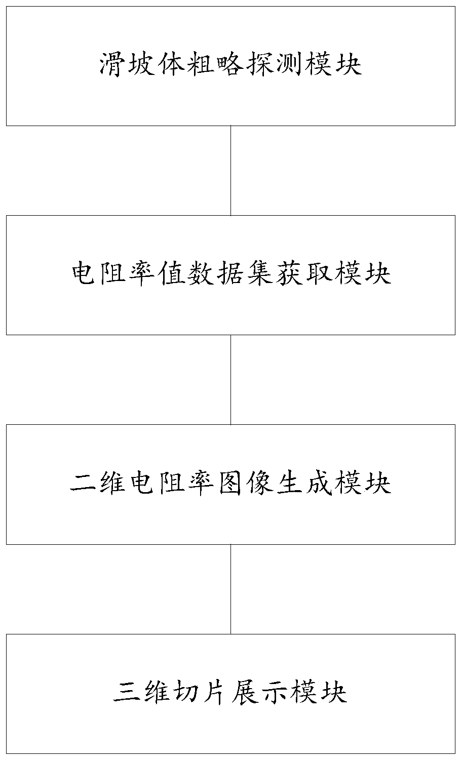
[0046] Such as figure 2 Shown, the three-dimensional imaging system of a kind of landslide body of the present embodiment, it comprises:

[0047] (1) The rough detection module of the landslide body, which is used to detect the landslide body by semi-aerial transient electromagnetic method, obtain the resistivity value of the underground medium, obtain the rough depth of the landslide body and the rough distribution range of the landslide body;

[0048] (2) Resistivity value data set acquisition module, which is used to divide the rough depth of the landslide body into several step depths within the rough distribution range of the landslide body, and adopt different survey lines at different step depths, along the survey line The transient electromagnetic point and high-density electrical point layout are carried out respectively, and the transient electromagnetic method and the high-density resistivity method are correspondingly used for geological survey, so as to obtain th...

Embodiment approach

[0051] As an implementation manner, the three-dimensional imaging system of the landslide body also includes:

[0052] Resistivity value data correction module, which is used to carry out drilling sampling at the inflection point of the landslide body or the preset position point at the slope toe, compare the sampled sample image with the image of the known resistivity value, and correct the corresponding The data in the corresponding first data set of resistivity values ​​and the second data set of resistivity values ​​are processed.

[0053] Specifically, in the resistivity value data correction module, the cross-well resistivity CT method is used to obtain the resistivity value at the drilling sampling place, and the first resistivity value data set and the second resistivity value data set corresponding to the corresponding treatment are corrected. The data in the data set are then subjected to two-dimensional resistivity inversion imaging.

[0054] As another implementat...


PUM


Abstract

The disclosure provides a three-dimensional imaging method and system of a landslide body. The three-dimensional imaging method of the landslide body comprises the following steps of: using a semi-aeronautical transient electromagnetic method to detect the landslide body to obtain a rough depth and a rough distribution range of the landslide body; dividing the rough depth of the landslide body into a number of step depths within the rough distribution range of the landslide body, using different survey lines at different step depths, performing transient electromagnetic point and high-densityelectrical method point arrangements separately along the survey lines, and using the transient electromagnetic method and a high-density resistivity method correspondingly to obtain a first resistivity value data set and a second resistivity value data set; screening out the resistivity value data corresponding to geological bodies exceeding the depth of 1/4 of the survey line length and the geological bodies not exceeding the depth of 1/4 the survey line length separately from the first resistivity value data set and the second resistivity value data set to perform imaging analysis and perform fusing to generate a two-dimensional resistivity image; and performing three-dimensional slice result show on the obtained two-dimensional image, so as to provide accurate data information for thetreatment of the landslide body.

Description

technical field [0001] The disclosure belongs to the field of landslides, and in particular relates to a three-dimensional imaging method and system for landslides. Background technique [0002] The statements in this section merely provide background information related to the present disclosure and do not necessarily constitute prior art. [0003] At present, only one method is often used for landslide surveys, so that the obtained survey data is inaccurate, and the 3D imaging maps obtained are also inaccurate, which affects the disaster management in the later stage; and the inventor also found that most of the existing landslide survey data use The way of manual data collection may cause data errors and loss of data information, which also affects the accuracy of the 3D imaging map. Contents of the invention [0004] In order to solve the above problems, the present disclosure provides a method and system for three-dimensional imaging of landslides, which can improve ...

Claims


Application Information

Patent Timeline
IPC IPC(8): G01N27/04G01V3/38
CPCG01N27/041G01V3/38
Inventor 苏茂鑫刘轶民薛翊国邱道宏李广坤程凯
Owner SHANDONG UNIV
Why Eureka
Try Eureka