Space-air-reservoir-bank integrated emergency survey data fusion and integrated display system and method

A survey data and data fusion technology, applied in the field of data processing, can solve problems such as poor precision, single data type, and low efficiency, and achieve the effects of stable and reliable performance, unified system architecture, and strong interoperability

Active Publication Date: 2020-03-06
SHANGHAI JIAO TONG UNIV
View PDF5 Cites 3 Cited by
  • Summary
  • Abstract
  • Description
  • Claims
  • Application Information

AI Technical Summary

Problems solved by technology

However, the types of data acquired by these devices are relatively single, unable to reflect the real geological and geomorphic information, and the accuracy is poor, which cannot meet the high-precision requirements of the mode

Method used


Image

  • Space-air-reservoir-bank integrated emergency survey data fusion and integrated display system and method
  • Space-air-reservoir-bank integrated emergency survey data fusion and integrated display system and method
  • Space-air-reservoir-bank integrated emergency survey data fusion and integrated display system and method

Examples


Embodiment Construction

[0048] The present invention will be described in detail below in conjunction with specific embodiments. The following examples will help those skilled in the art to further understand the present invention, but do not limit the present invention in any form. It should be noted that those skilled in the art can make several changes and improvements without departing from the concept of the present invention. These all belong to the protection scope of the present invention.

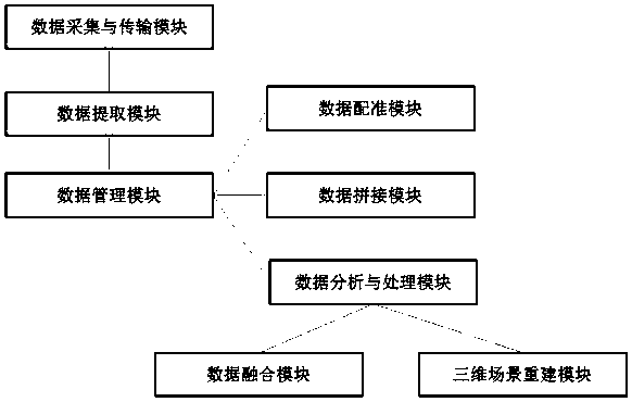
[0049] Such as figure 1 , an integrated air-space library-shore emergency survey data fusion and integrated display system, including: data acquisition and transmission module, data extraction module, data management module, data registration module, data splicing module, data analysis and processing module, data Fusion module, 3D scene reconstruction module; where:

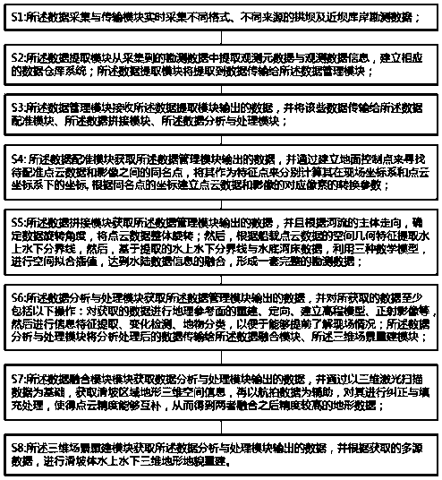
[0050] The data collection and transmission module: used for real-time collection of survey data of arch dams and banks near dams in dif...


PUM


Abstract

The invention provides an air-space-reservoir-bank integrated emergency survey data fusion and integrated display system and method. The air-space-reservoir-bank integrated emergency survey data fusion and integrated display system comprises a data acquisition and transmission module, a data extraction module, a data management module, a data registration module, a data splicing module, a data analysis and processing module, a data fusion module and a three-dimensional scene reconstruction module, wherein the data extraction module is connected with the data acquisition and transmission module; the data management module is connected with the data extraction module; the data registration module is connected with the data management module; the data splicing module is connected with the data management module; the data analysis and processing module is connected with the data management module; the data fusion module is connected with the data analysis and processing module; and the three-dimensional scene reconstruction module is connected with the data analysis and processing module. According to the air-space-reservoir-bank integrated emergency survey data fusion and integrated display system, the range and the condition of the affected area can be rapidly and accurately surveyed in detail, and the survey result is obtained.

Description

technical field [0001] The invention relates to the technical field of data processing, in particular to a system and method for integrating emergency survey data fusion and integrated display of space, storage and shore. Background technique [0002] Large-scale geological disasters such as landslides and debris flows are extremely destructive and often cause a large number of economic losses and casualties. Therefore, how to study them has become a hot issue in the long-term safe and stable operation of arch dams and near dam banks. The purpose of geological disaster research is to understand the formation mechanism and failure mode of landslides, predict its long-term stability, and then determine the prevention and control methods of geological disasters. In order to express the temporal and spatial distribution characteristics and location forms of geological hazards, it is necessary to perform 3D reconstruction of geological hazards. [0003] At present, driven by com...

Claims


Application Information

Patent Timeline
IPC IPC(8): G06T17/05G06F16/29
CPCG06T17/05G06F16/29Y02A90/30
Inventor 季昊巍罗先启
Owner SHANGHAI JIAO TONG UNIV
Why Eureka
Try Eureka