Data fusion and display method based on urban space three-dimensional grid model

A grid model and spatial three-dimensional technology, applied in the information field, can solve problems such as difficult spatial data association, weak data association ability, and unsuitable 3D model of urban spatial data.

Active Publication Date: 2020-03-10
北斗伏羲中科数码合肥有限公司
View PDF9 Cites 19 Cited by
  • Summary
  • Abstract
  • Description
  • Claims
  • Application Information

AI Technical Summary

Problems solved by technology

[0032]1) In terms of 3D model construction, the period is long, the cost is high, and the requirements for surveying and design data are high, so it is difficult to quickly form a 3D model of urban space
[0033]2) High requirements for basic dat

Method used


Image

  • Data fusion and display method based on urban space three-dimensional grid model
  • Data fusion and display method based on urban space three-dimensional grid model
  • Data fusion and display method based on urban space three-dimensional grid model

Examples


Embodiment Construction

[0076] The present invention will be described in detail below with reference to the accompanying drawings and examples.

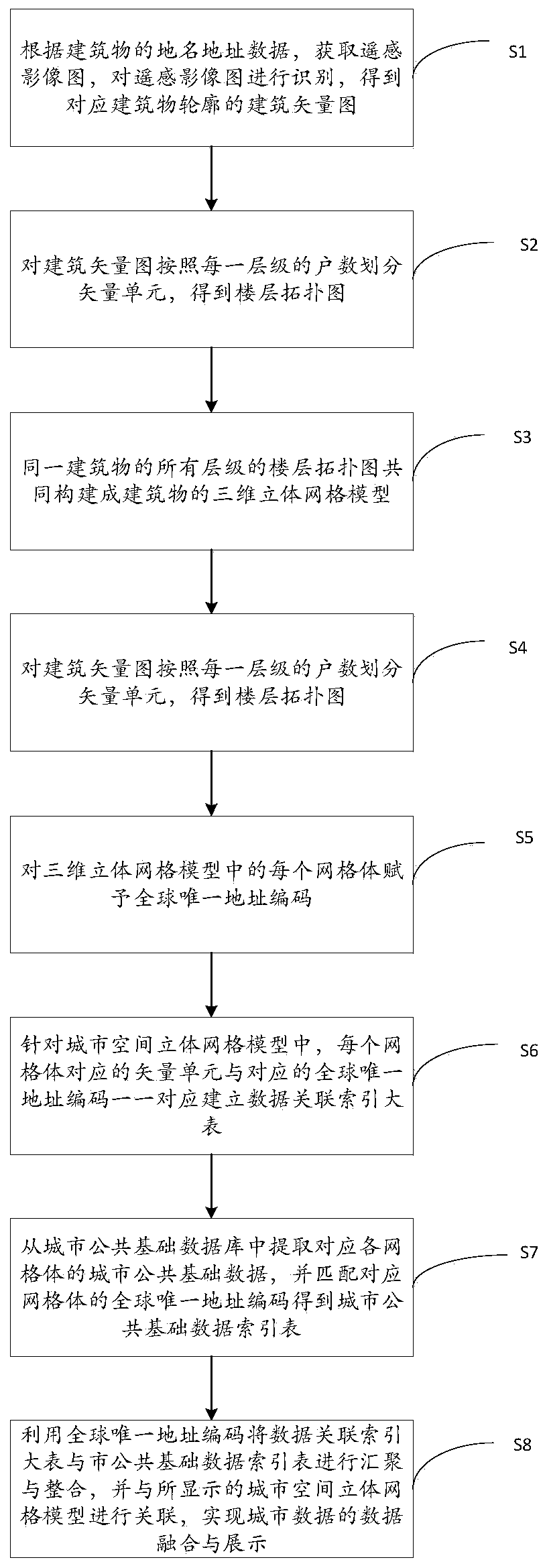
[0077] The present invention provides a data fusion and display method based on a three-dimensional grid model of urban space, the process of which is as follows figure 1 shown, including the following steps:

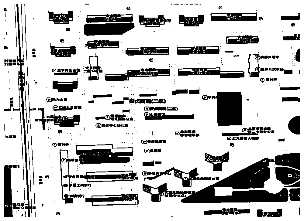
[0078] S1. Obtain a remote sensing image map according to the place name address data of the building, identify the remote sensing image map, and obtain a building vector map corresponding to the outline of the building.

[0079] Specific method: Obtain the place name and address data of the building in the urban public basic database, match the longitude and latitude information of the center point of the building through the place name and address data, and then obtain the remote sensing image map of the building, and identify the building based on the remote sensing image map The outline and latitude and longitude range of the building, and the ...


PUM


Abstract

The invention discloses a data fusion and display method based on an urban space three-dimensional grid model. The urban space three-dimensional grid model which is low in requirement for basic data and high in data relevance is constructed. The method specifically comprises the steps of establishing a building vector diagram corresponding to a building contour, and dividing vector units to obtaina floor topological diagram. The floor topological graphs of all levels of the same building form a three-dimensional grid model of the building. And the three-dimensional grid models of all the buildings in the city form an urban space three-dimensional grid model and are displayed. Each grid body in the three-dimensional grid model is endowed with a globally unique address code, and a data association index large table is established by utilizing the grid body and the corresponding globally unique address code. Urban public basic data of each grid body are extracted from the urban public basic database, an urban public basic data index table is established, the tables are converged and integrated, and the tables are associated with the urban space three-dimensional grid model to realizedata fusion and display of urban data.

Description

technical field [0001] The invention relates to the field of information technology, in particular to a data fusion and display method based on a three-dimensional grid model of urban space. Background technique [0002] With the acceleration of urbanization and global economic integration, while cities are developing rapidly, they are also facing many problems in sustainable development. The existing urban management model has been limited, and new technologies and measures must be sought. Realize digital urban management, thereby optimizing resource allocation, improving management level, and improving the ability to serve the people. [0003] The digital city management model uses new technologies such as big data, cloud computing, mobile Internet, and the Internet of Things to realize the integrated management of urban public basic data. In the process of digital city management, one of the more important technical means is to establish a three-dimensional model of the ...

Claims


Application Information

Patent Timeline
IPC IPC(8): G06F16/29G06F30/13G06T17/05
CPCG06T17/05G06F16/29
Inventor 黄朔任伏虎伍学民张亚强袁禄军赵宇斐
Owner 北斗伏羲中科数码合肥有限公司
Why Eureka
Try Eureka