Satellite navigation interference source passive positioning method based on multi-platform cooperation

A satellite navigation and passive positioning technology, applied in satellite radio beacon positioning systems, radio wave measurement systems, instruments, etc., to solve problems such as interference and failure of members' satellite navigation and positioning equipment

Active Publication Date: 2020-04-10
NO 20 RES INST OF CHINA ELECTRONICS TECH GRP
View PDF5 Cites 7 Cited by
  • Summary
  • Abstract
  • Description
  • Claims
  • Application Information

AI Technical Summary

Problems solved by technology

In order to solve the problem that member satellite navigation and positioning equipment cannot work normally due to interference under the current environment, the technical problem to be solved by the present invention is: in the case of multi-platform network coordination, use the satellite navigation interference source azimuth data obtained by multiple platforms Sharing, using multi-platform passive direction finding and cross-location technology to solve the position of the interference source of satellite guidance, provide effective information for subsequent strikes and destruction, and improve the performance of each unit

Method used


Image

  • Satellite navigation interference source passive positioning method based on multi-platform cooperation
  • Satellite navigation interference source passive positioning method based on multi-platform cooperation
  • Satellite navigation interference source passive positioning method based on multi-platform cooperation

Examples


Embodiment Construction

[0077] The present invention will be further described below in conjunction with the accompanying drawings and embodiments.

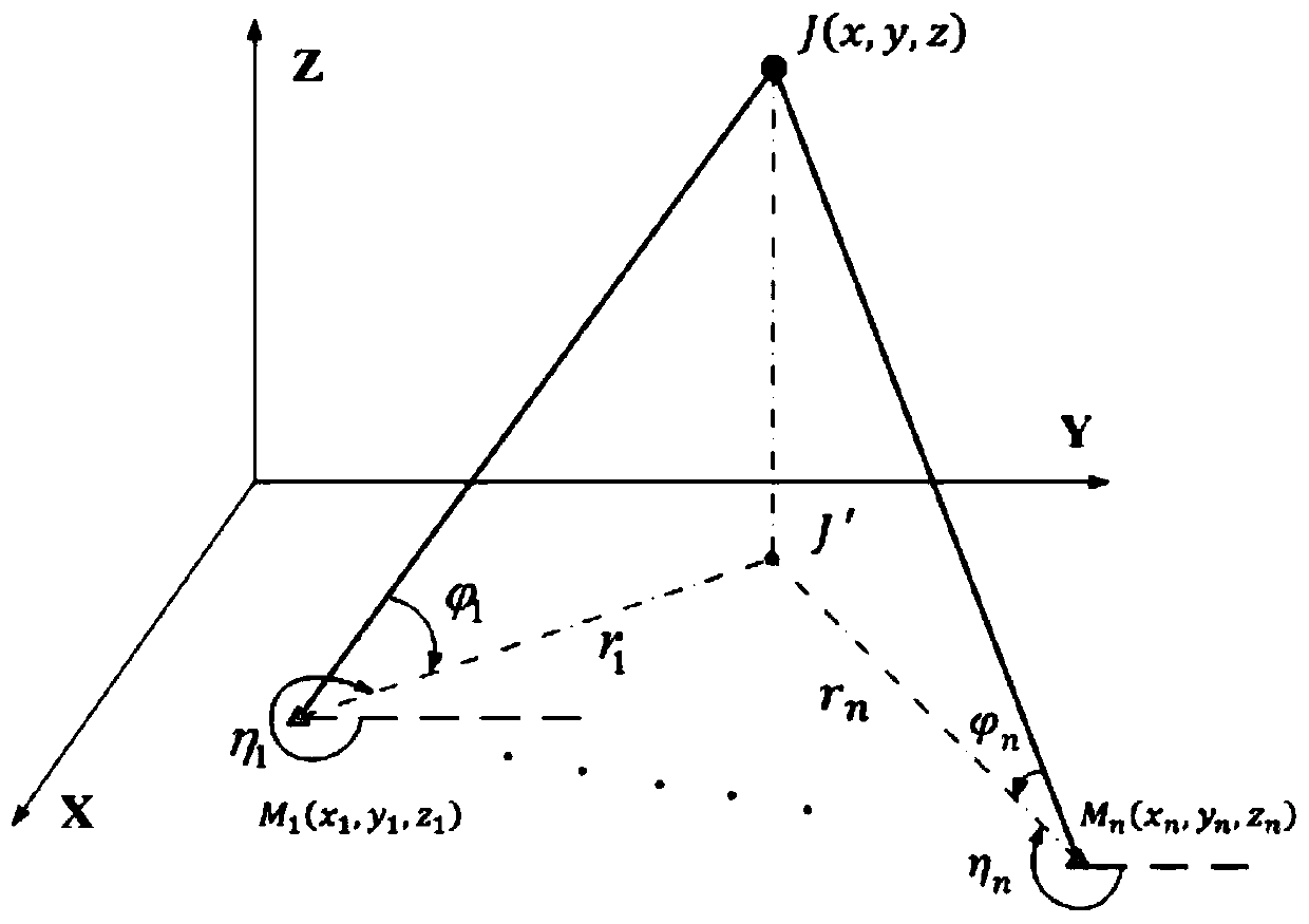
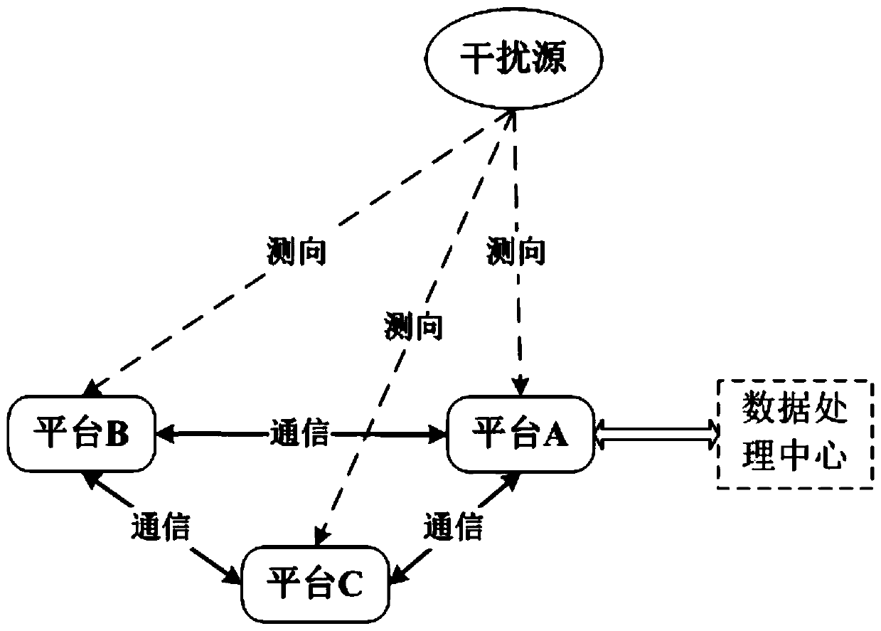
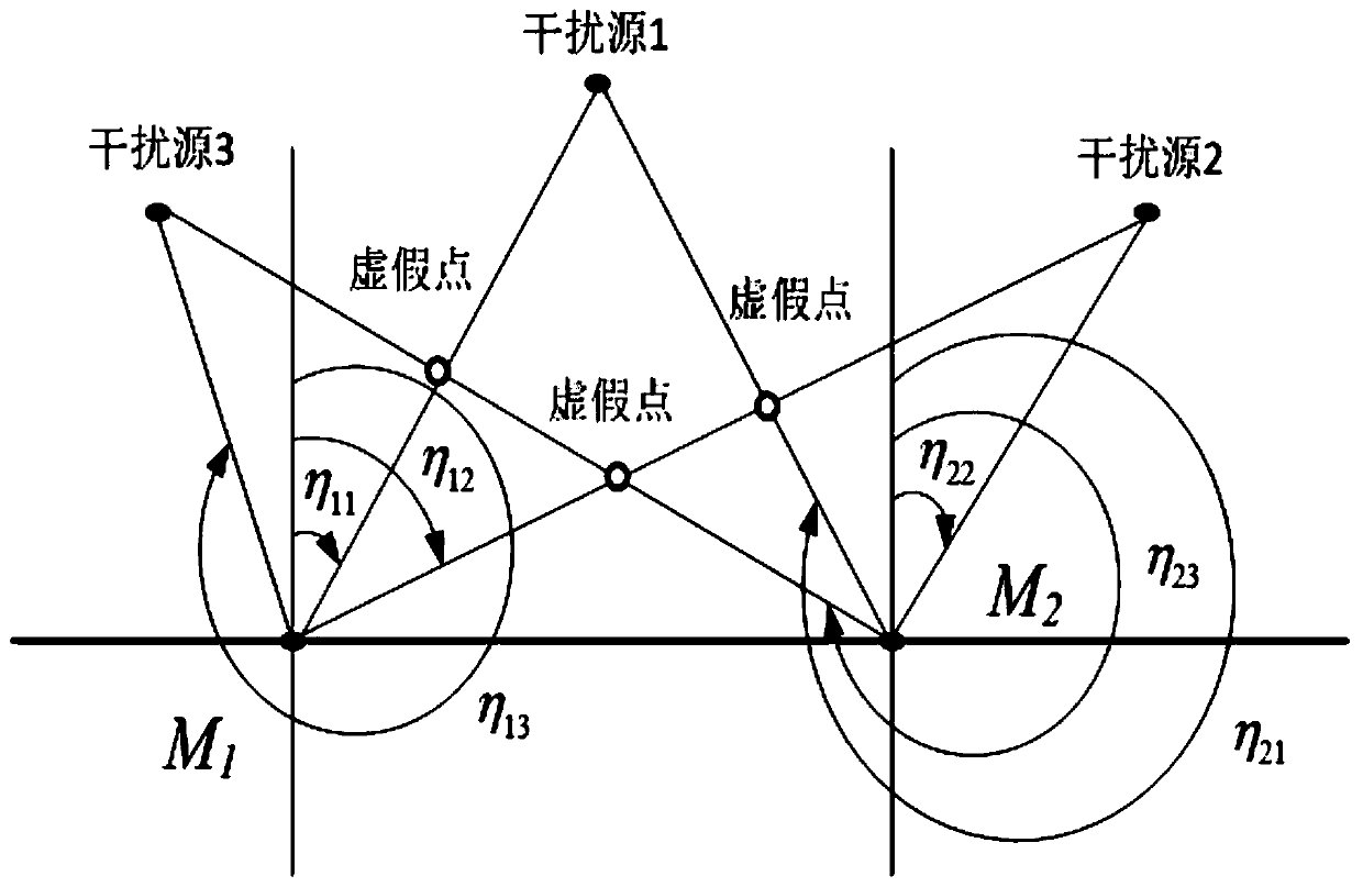
[0078] The invention proposes a satellite navigation interference source passive positioning method based on multi-platform cooperation on the basis of the principle of passive direction finding cross positioning. This method draws on the concept of passive radar network positioning, uses the data communication links on the platform to store the direction finding data of satellite navigation interference sources obtained by multiple platforms in real time in the data computing center, and uses the targets measured by multiple platforms For azimuth information, the passive direction finding cross-location algorithm is used to realize the position estimation of satellite navigation interference sources. At the same time, the elimination of false positioning results does not require too much additional auxiliary measurement information, and there are fewer ...


PUM


Abstract

The invention provides a satellite navigation interference source passive positioning method based on multi-platform cooperation. Under the condition of networking cooperation of a plurality of combatplatforms, satellite navigation interference source orientation data obtained by the plurality of combat platforms are shared, and the position of a satellite navigation interference source is calculated by adopting a multi-platform passive direction-finding cross positioning technology, so that effective battlefield information is provided for subsequent combat destroy, and the combat performance of each combat unit is improved. The method is good in concealment, and position information of the device is not exposed; the problems that calculation dead angles exist in double-platform positioning and false points are solved can be effectively avoided, and real-time three-dimensional positioning can be carried out on an interference source; the data volume is greatly reduced, the calculation amount is smaller, the calculation capability is saved, and the influence on the normal operation of other functions is very small; false points possibly occurring in positioning calculation are effectively reduced, the calculation pressure of combat member platform equipment is reduced, the utilization efficiency of battlefield networked information data is enhanced, and the accuracy of combatinstructions is improved.

Description

technical field [0001] The invention relates to the field of radio navigation and positioning, in particular to a satellite navigation interference source positioning method. Background technique [0002] Due to the small size and low transmission power of satellite navigation jamming equipment, it is difficult to accurately detect satellite navigation jamming sources even if proprietary satellite navigation jamming source detection equipment (such as the "Signal Sentinel 1000" GPS jamming source detection system in the United States) is used Orientation (or position), and this active detection of satellite navigation interference source equipment is often easy to expose its own target position, and also increases the equipment cost of the application platform. [0003] Passive positioning technology uses the receiving device to receive the signal of the radiation source to determine the position of the radiation source. For this reason, for the detection of satellite navig...

Claims


Application Information

Patent Timeline
Patent Type & Authority Applications(China)
IPC IPC(8): G01S19/21G01S19/01
CPCG01S19/21G01S19/015
Inventor 李江吴林旭姚锦涛王宇琦
Owner NO 20 RES INST OF CHINA ELECTRONICS TECH GRP
Why Eureka
Try Eureka