Low-power-consumption satellite navigation mobile acquisition system and method in cross-region scene

A satellite navigation and acquisition system technology, applied in the field of satellite navigation, can solve the problems of high processing pressure and transmission pressure, many types, high maintenance costs, etc., achieve the effect of optimizing positioning accuracy, optimizing solution efficiency, and improving the quality of observation data

Active Publication Date: 2020-04-10
长沙金维信息技术有限公司
View PDF7 Cites 1 Cited by
  • Summary
  • Abstract
  • Description
  • Claims
  • Application Information

AI Technical Summary

Problems solved by technology

The existing satellite navigation monitoring and evaluation system still has the following limitations: (1) It is mainly used to monitor the overall operation status of the satellite navigation system, and is not suitable for flexible application scenarios of observation data for a large number of users; (2) The network coverage of the collection station is limited, The spatial correlation between its observation environment and the user’s observation environment is low. If a large number of collection stations need to be built according to the existing plan to expand the monitoring coverage, the maintenance cost will be high; Handle pressure and deliver high pressure
Therefore, there is a certain delay in transmission and processing, and the evaluation results cannot be directly accessed by users in a timely manner for users to use. Most monitoring and evaluation services and products need to be downloaded from the website for post-calculation comparison and analysis, and the time correlation of observation data products Low

Method used


Image

  • Low-power-consumption satellite navigation mobile acquisition system and method in cross-region scene
  • Low-power-consumption satellite navigation mobile acquisition system and method in cross-region scene
  • Low-power-consumption satellite navigation mobile acquisition system and method in cross-region scene

Examples


Embodiment Construction

[0070] The present invention will be further described below in conjunction with specific embodiment and accompanying drawing:

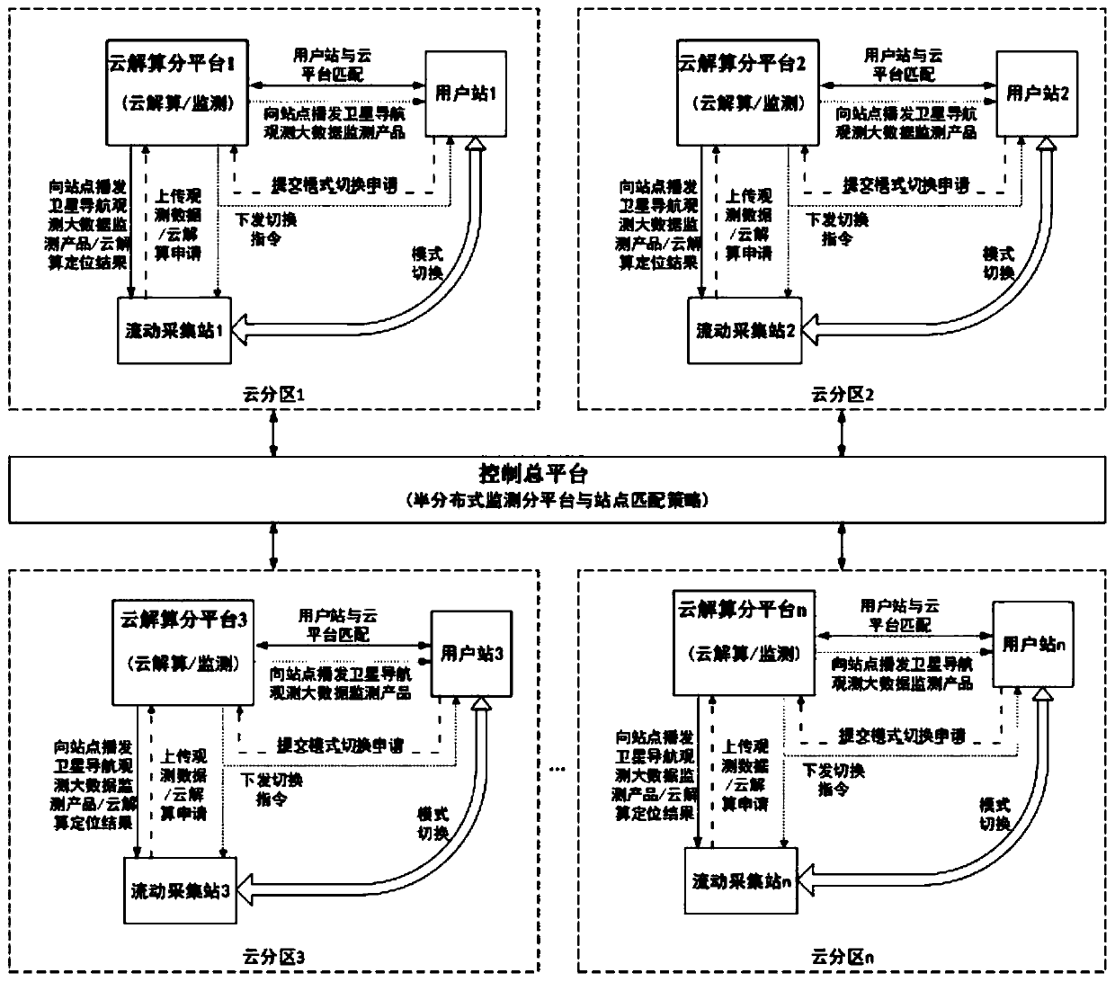
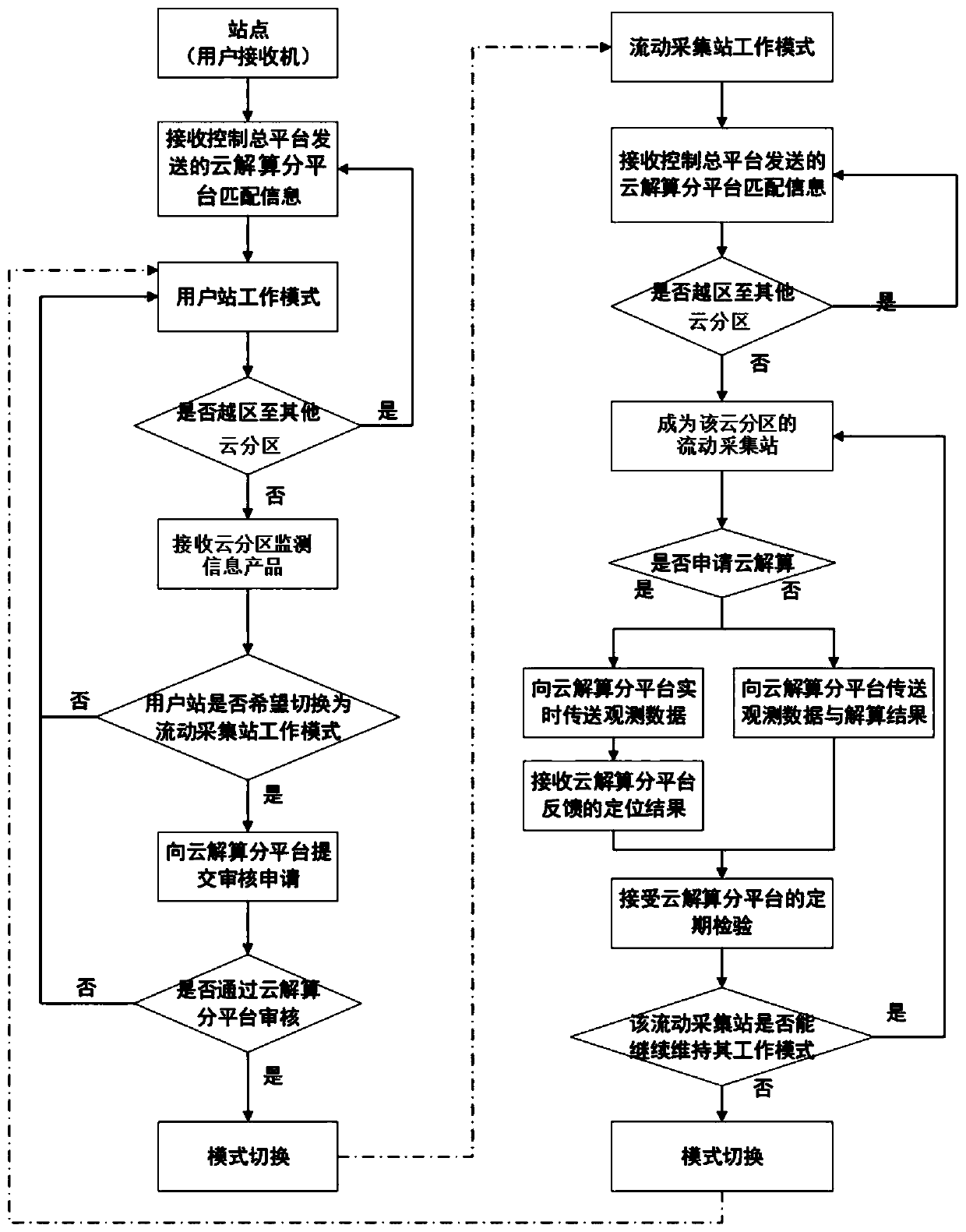
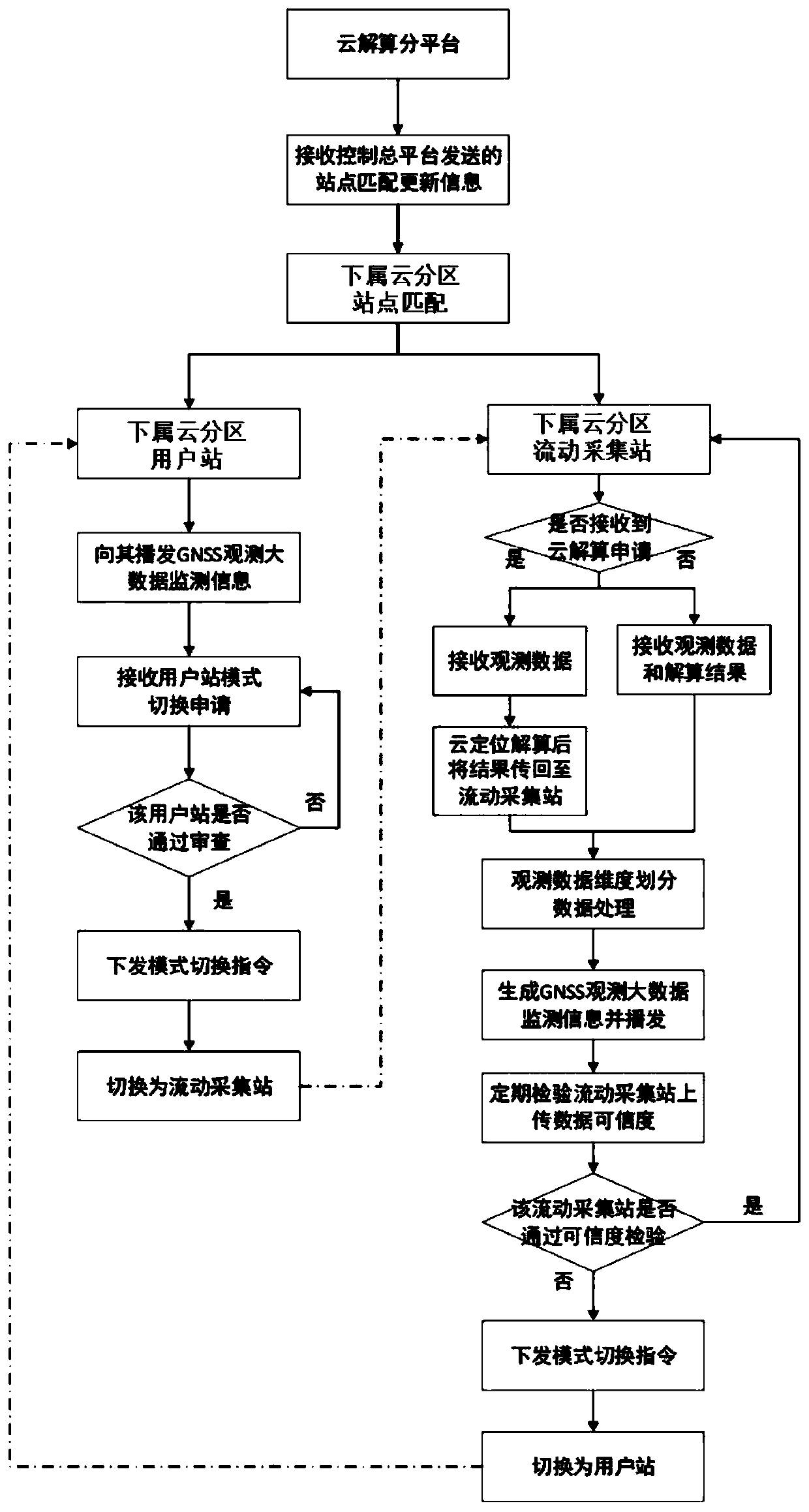
[0071] figure 1It is a schematic diagram of the principle of the low-power satellite navigation flow acquisition system in the cross-regional scene in this embodiment. The system includes a total control platform, a cloud computing sub-platform and a site, and the cloud computing sub-platform is connected to multiple sites. The solution sub-platform and the site form a cloud partition, and the control platform is connected to multiple cloud partitions; the station includes two working modes of the user station and the mobile collection station, and does not need to have the positioning and calculation function; the cloud solution The sub-platform has the functions of monitoring and positioning calculation;

[0072] General control platform: This solution requires a total control platform, with multiple cloud computing sub-platforms under it, which a...


PUM


Abstract

The invention discloses a low-power-consumption satellite navigation mobile acquisition system and method in a cross-regional scene, and the system comprises a control main platform, a cloud resolvingsub-platform and stations. The cloud resolving sub-platform is connected with a plurality of stations, the cloud resolving sub-platform and the stations form cloud partitions, and the control main platform is connected with a plurality of cloud partitions. The stations comprise two working modes of a user station and a mobile acquisition station, and do not need to have a positioning calculationfunction. The cloud resolving sub-platform has monitoring and positioning resolving functions. The mobile acquisition station does not need to have a positioning calculation function, only needs to complete data acquisition and transmission, and sends observation data to the cloud calculation platform to realize positioning calculation, so that the operation pressure and power consumption of the station positioning terminal can be greatly reduced, and the service life of the positioning terminal is prolonged.

Description

technical field [0001] The invention belongs to the technical field of satellite navigation, and in particular relates to a low-power consumption satellite navigation flow acquisition system and method in a cross-regional scene. Background technique [0002] Under the background of the rapid development of satellite navigation technology and increasingly fierce competition, the performance of satellite navigation system has gradually attracted widespread attention. The performance of satellite navigation system directly affects its operation and service level. The main goal of satellite navigation monitoring and evaluation is to establish a global near-real-time tracking network with full arc and multiple coverage of navigation satellites, and an information service platform with data collection, storage, analysis, management, and release functions to monitor the operation of the global satellite navigation system. The status and main performance indicators are monitored and...

Claims


Application Information

Patent Timeline
Patent Type & Authority Applications(China)
IPC IPC(8): G01S19/37G01S19/08
CPCG01S19/37G01S19/08Y02D30/70
Inventor 涂传亮蒋云翔刘旭华庞浩冷如松张珊田震华刘彦叶军
Owner 长沙金维信息技术有限公司
Why Eureka
Try Eureka