A system and method for calculating calibration point spatial distance based on image midpoint attribute data set

A technology of attribute data and calibration points, which is applied in image data processing, calculation, image enhancement, etc., and can solve problems such as the calibration of the spatial distance between points that cannot be identified in static two-dimensional images, and the effective distance is short

Pending Publication Date: 2020-04-17
吴怡锦
View PDF15 Cites 2 Cited by
  • Summary
  • Abstract
  • Description
  • Claims
  • Application Information

AI Technical Summary

Problems solved by technology

[0003] The above methods still cannot solve the calibration of the space distance between points that can be identified in the static two-dimensional image after shooting. The ARkit ruler realizes the calibration of the straight line length using the image, but there are three shortcomings: the measurement operation process still needs to be directed against the real object. It cannot be separated from the real object; it can get the straight-line distance between two points, and if the curve is artificially divided into straight-line segments for calibration; the effective distance is short, and it is invalid for a slightly longer distance

Method used


Image

  • A system and method for calculating calibration point spatial distance based on image midpoint attribute data set
  • A system and method for calculating calibration point spatial distance based on image midpoint attribute data set

Examples


Embodiment 1

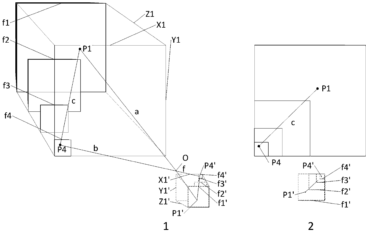
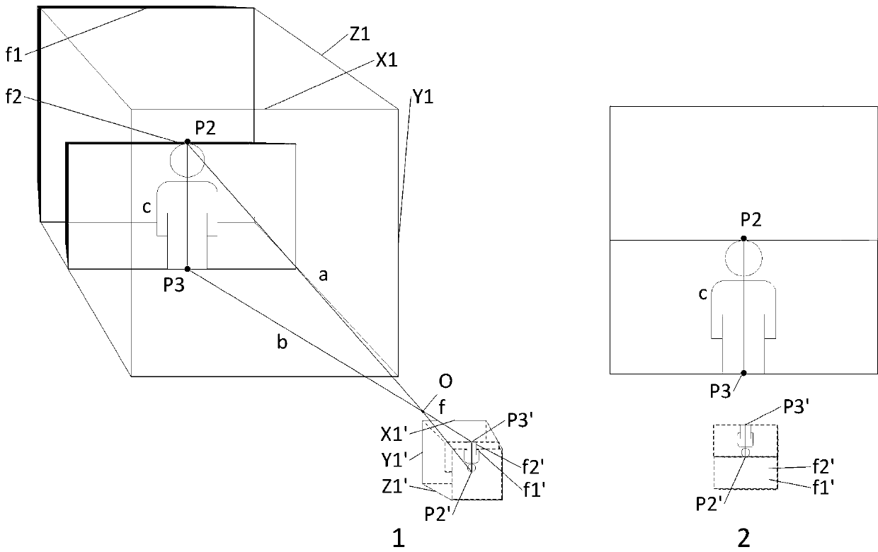
[0027] Example 1, shooting in the mode of active focus distance measurement and fixed image distance, assuming that the camera is perpendicular to the ground and fixed, according to the object distance between the head focus and the light spot and the object distance between the foot focus and the light spot, combined with the camera focal length, the image distance can be obtained , assuming that the person stands perpendicular to the ground, then the third side, that is, the distance between two points, that is, the height can be calculated according to the two sides of the triangle and the length of the vertical line. The existing technology that can be compared with this example is that people lean against the ruler when taking photos in special cases. After using the present invention, the coordinates of the focusing point replace the ruler behind the person.

Embodiment 2

[0028] Embodiment 2, on the basis of the idea described in Embodiment 1, if the person’s standing posture is leaning forward or backward, two focal points can be recorded in one image when shooting, or one focal point can be recorded in two images respectively. For the attribute data set, if the camera moves during the two shots, the coordinate system of the two images needs to be corrected. The correction of the subsequent image sets is the same, so I won’t go into details. Because some attribute data sets can judge that the coordinates of the head and feet are not in the same section when a person is standing, the vertical height can be obtained through calculation. Similarly, the standing posture can be corrected for left or right leaning, which will not be described later. If the camera is not perpendicular to the ground, the origin of the coordinate system does not change, but it will cause the cross section of the focus point in the coordinate system to change accordingly...

Embodiment 3

[0029] Embodiment 3, on the basis of the ideas described in the preceding embodiments, the passive focus method is used for shooting. In this way, the top of the head and the bottom of the feet can be fixed in focus by contrast or phase detection, and the image distance can be obtained, and the image distance and focal length of the lens can be recorded. , the object distance can be calculated, and other situations are the same as in Embodiment 2.


PUM


Abstract

The invention discloses a system and method for calculating a calibration point space distance based on an image midpoint attribute data set. The method comprises the following steps of making an image and/or an image set capable of calibrating relevant parameters of recognizable points; focusing and calibrating recognizable points, recording attribute parameters of each point with the attribute parameters including the position and angle of a camera, the focal length and image distance parameters of a lens, the image distance of each focus of an image, coordinate position parameters in the image and the like, forming an image point attribute data set, particularly a space attribute data set, and calculating the space distance of calibrated image points by using the data set, calibrating afocusing point in the image as an identifiable point and recording attribute parameters; converting the image distance and the lens focal length corresponding to each point into the distance from thefocusing point cross section to the light spot, namely the object distance; for an established optical system, calibrating and correcting the correlation and errors between the object distance and the focal distance and between the object distance and the image distance, calculating the spatial coordinates of the points by adding data sets such as the position coordinates of the points in the image, and acquiring the spatial distances between the points according to the spatial coordinates of the points.

Description

technical field [0001] The present invention calibrates the point attributes of a digital image, forms an image point attribute data set, uses the data set to calculate and calibrate the spatial distance of image points, and relates to the fields of optics, image photography, digital images, data sets, three-dimensional space positioning, measurement and calculation, and computer technology. In particular, it relates to a system and method for calculating the spatial distance of calibration points based on a point attribute data set in an image. Background technique [0002] The current methods for calibrating the distance between two points are: 1. ruler measurement; 2. laser (infrared, sound wave, ultrasonic, etc.) distance measurement; 3. visual inertial measurement system VIO in the video system. The above three methods are for real-time measurement of real objects. At present, the ARkit ruler in Apple’s iOS12 is based on SLAM synchronous positioning and mapping technolo...

Claims


Application Information

Patent Timeline
Patent Type & Authority Applications(China)
IPC IPC(8): G06T7/80G06T7/70
CPCG06T7/80G06T7/70G06T2207/30196
Inventor 吴怡锦
Owner 吴怡锦
Why Eureka
Try Eureka