Surface subsidence monitoring system and method based on high-resolution remote sensing satellite

A technology for remote sensing satellites and surface subsidence, applied in the field of monitoring systems, can solve problems such as inducing social and economic problems, destroying production and living facilities, and affecting monitoring effects, and achieves the effect of reducing the difficulty of image analysis.

Pending Publication Date: 2020-05-05
XIAMEN KINGTOP INFORMATION TECH
View PDF0 Cites 3 Cited by
  • Summary
  • Abstract
  • Description
  • Claims
  • Application Information

AI Technical Summary

Problems solved by technology

[0003] At present, the number of cities suffering from land subsidence is increasing. Land subsidence leads to the occurrence of various disasters, such as seawater intrusion or storm surge. Various geological disasters caused by land subsidence are important factors that seriously restrict the urban process. Resource crisis causes a series of ecological and environmental problems at the same time, destroys production and living facilities, and may induce social and economic problems
Using high-resolution earth observation technology, the surface subsidence area can be found in time by comparing the changes in the three-dimensional images of the surface. The measurement error caused by the meter-level accuracy will still affect the monitoring effect, so it is necessary to install monitoring devices at the serious points of surface subsidence to assist high-resolution earth observation technology to achieve comprehensive and effective monitoring of surface subsidence areas

Method used


Image

  • Surface subsidence monitoring system and method based on high-resolution remote sensing satellite
  • Surface subsidence monitoring system and method based on high-resolution remote sensing satellite
  • Surface subsidence monitoring system and method based on high-resolution remote sensing satellite

Examples


Embodiment Construction

[0056] A high-resolution remote sensing satellite-based land subsidence monitoring system of the present invention will be further described in detail below in conjunction with the drawings and embodiments.

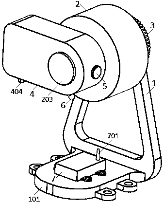
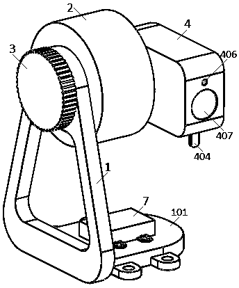
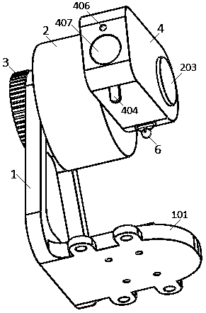
[0057] The surface subsidence monitoring system based on high-resolution remote sensing satellites is characterized in that it includes a reference point outside the subsidence area and a measuring device, wherein the measuring device includes a bracket 1, a motor 2, a fastening knob 3, a rangefinder 4, a pin 5, a calibration Ball 6, communication box 7.

[0058] Such as Figure 18 As shown in , the observation points outside the subsidence area are marked on buildings with a certain height outside the subsidence area.

[0059] The measuring devices are installed at the most severe points in the subsidence area.

[0060] Such as figure 1 , figure 2 , image 3 , Figure 13 , Figure 15 As shown, the support 1 is an upright triangular frame, and the bottom of the tr...


PUM


Abstract

The invention provides a surface subsidence monitoring system based on a high-resolution remote sensing satellite. The surface subsidence monitoring system comprises a reference point outside a subsidence area and a measuring device, and the measuring device comprises a support, a motor, a fastening knob, a range finder, a pin, a calibration ball and a communication box. The motor is installed onthe support through a fastening knob, the range finder is installed on the output shaft of the motor through the pin, the calibration ball is hinged to the bottom face of the tail end of the range finder, and a laser emitted by the calibration ball is always horizontally forward. A calibration laser receiver is arranged on the bottom surface of the front end of the range finder; a distance measuring laser emitter and a distance measuring laser receiver are arranged on the head end surface of the distance measuring instrument; the communication box is arranged on the top surface of the horizontal plate at the bottom of the bracket; a processor and a communication element are arranged in the communication box; the measuring device is installed at a serious point position of a settlement areamonitored by a high-resolution remote sensing satellite, the vertical distance between a reference point and a monitoring point outside the settlement area is measured by using a trigonometric function, and when the settlement distance and the settlement speed exceed respective threshold values, a warning signal is sent to a system background.

Description

technical field [0001] The invention relates to a monitoring system, in particular to a surface subsidence monitoring system based on high-resolution remote sensing satellites. Background technique [0002] High-resolution remote sensing satellite earth observation technology can constitute an all-weather, all-time, global coverage earth observation system with high spatial, high time, and high spectral resolution. The construction of a high-resolution earth observation system is of great significance to promoting the construction of China's space infrastructure, cultivating satellite applications and the development of strategic emerging industries. With the construction of high-resolution special projects, the monitoring accuracy of high-resolution satellites has reached the sub-meter level, and ordinary satellite data has been replaced by high-resolution special data. High score data has been widely used in land, surveying and mapping, agriculture, forestry, environmenta...

Claims


Application Information

Patent Timeline
Patent Type & Authority Applications(China)
IPC IPC(8): G01C5/00
CPCG01C5/00
Inventor 田瑜基邱祥峰陈云张鸿玮
Owner XIAMEN KINGTOP INFORMATION TECH
Why Eureka
Try Eureka