Disaster evaluation and analysis method based on GIS

An analysis method and disaster technology, applied in the field of disaster evaluation and analysis based on GIS, can solve the problems of inability to analyze and evaluate disasters, and inability to predict disasters, and achieve the effect of reducing losses and ensuring accuracy.

Pending Publication Date: 2020-05-12
兰州大方电子有限责任公司
View PDF7 Cites 12 Cited by
  • Summary
  • Abstract
  • Description
  • Claims
  • Application Information

AI Technical Summary

Problems solved by technology

[0005] The purpose of the present invention is: in order to solve the problem that the existing technology cannot provide early warning of the upcoming disaster and cannot analyze and evaluate the ongoing disaster, provide effective protection and rescue measures, and cause the disaster to cause heavy losses. The present invention provides a Disaster Evaluation and Analysis Method Based on GIS

Method used


Image

  • Disaster evaluation and analysis method based on GIS
  • Disaster evaluation and analysis method based on GIS

Examples


Embodiment 1

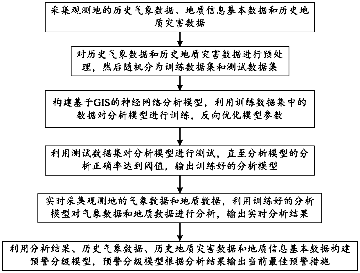
[0027] Such as figure 1 As shown, the present embodiment provides a GIS-based disaster evaluation analysis method, including the following steps:

[0028] S1: Collect historical meteorological data, basic geological information data and historical geological disaster data of the observation site, and construct a multi-source GIS database of the observation site based on the basic geological information data;

[0029] Among them, historical meteorological data include but are not limited to: rainfall in four seasons, temperature values, humidity values, high-air cyclone pressure, wind direction, wind force, and air pressure around the wind field at the observation site; basic geological information data include but are not limited to: geographical location of the observation site, socioeconomic General situation, river system, geological appearance, soil type and distribution and land use type; historical geological disaster data include but not limited to: flood river flow, de...


PUM


Abstract

The invention discloses a GIS-based disaster evaluation and analysis method, which relates to the technical field of geological disaster analysis and evaluation, and comprises the steps of collectinghistorical meteorological data, geological information basic data and historical geological disaster data of an observation place; preprocessing: dividing the data into a training data set and a testdata set; constructing a GIS-based neural network analysis model, training the analysis model, and reversely optimizing model parameters; testing the analysis model, and outputting the trained analysis model; acquiring meteorological data and geological data of an observation site in real time, analyzing the meteorological data and the geological data by using the trained analysis model, and outputting a real-time analysis result; the real-time analysis result, the historical meteorological data, the historical geological disaster data and the geological information basic data are utilized toconstruct the early warning grading model, and the early warning grading model outputs the current optimal early warning measure according to the real-time analysis result, so that the accuracy of thereal-time analysis result is improved, and the loss caused by disasters is reduced.

Description

technical field [0001] The invention relates to the technical field of geological disaster analysis and evaluation, and more specifically relates to a GIS-based disaster evaluation and analysis method. Background technique [0002] Geographic Information System (Geographic Information System or Geo-Information system, GIS) is sometimes called "geographic information system". It is a specific and very important spatial information system. It is a technical system that collects, stores, manages, calculates, analyzes, displays and describes the relevant geographical distribution data in the entire or part of the earth's surface (including the atmosphere) space with the support of computer hardware and software systems. GIS is a computer-based tool that can analyze and process spatial information, in short, map and analyze the phenomena and events that exist on the earth. GIS technology integrates the unique visual effects and geographic analysis functions of maps with general...

Claims


Application Information

Patent Timeline
Patent Type & Authority Applications(China)
IPC IPC(8): G06Q10/04G06F16/29G06N3/04G06N3/08G06Q50/26
CPCG06Q10/04G06F16/29G06Q50/26G06N3/08G06N3/045Y02A90/10
Inventor 李晓纯李扬于娟
Owner 兰州大方电子有限责任公司
Why Eureka
Try Eureka