Logistics transportation unmanned aerial vehicle flight path planning method

A flight path and unmanned aerial vehicle technology, applied in the field of unmanned aerial vehicles, can solve the problems that items cannot be delivered to customers quickly in a short time, increase the operating cost of express companies, and reduce the efficiency of logistics and transportation, so as to save manpower and reduce Courier personnel, the effect of reducing road traffic congestion

Pending Publication Date: 2020-05-15
BEIJING TECHNOLOGY AND BUSINESS UNIVERSITY
View PDF8 Cites 2 Cited by
  • Summary
  • Abstract
  • Description
  • Claims
  • Application Information

AI Technical Summary

Problems solved by technology

[0004] In order to achieve the above purpose, the present invention provides a flight path planning method for logistics transportation UAVs, which solves the problem that most of the existing logistics transportation uses manpower to arrange and deliver objects. This delivery method not only improves the operation of express companies The cost also reduces the transportation efficiency of logistics, and the goods cannot be delivered to customers quickly in a short time, which causes road traffic congestion and causes great inconvenience to people's daily travel.

Method used


Image

  • Logistics transportation unmanned aerial vehicle flight path planning method
  • Logistics transportation unmanned aerial vehicle flight path planning method
  • Logistics transportation unmanned aerial vehicle flight path planning method

Examples


Embodiment 1

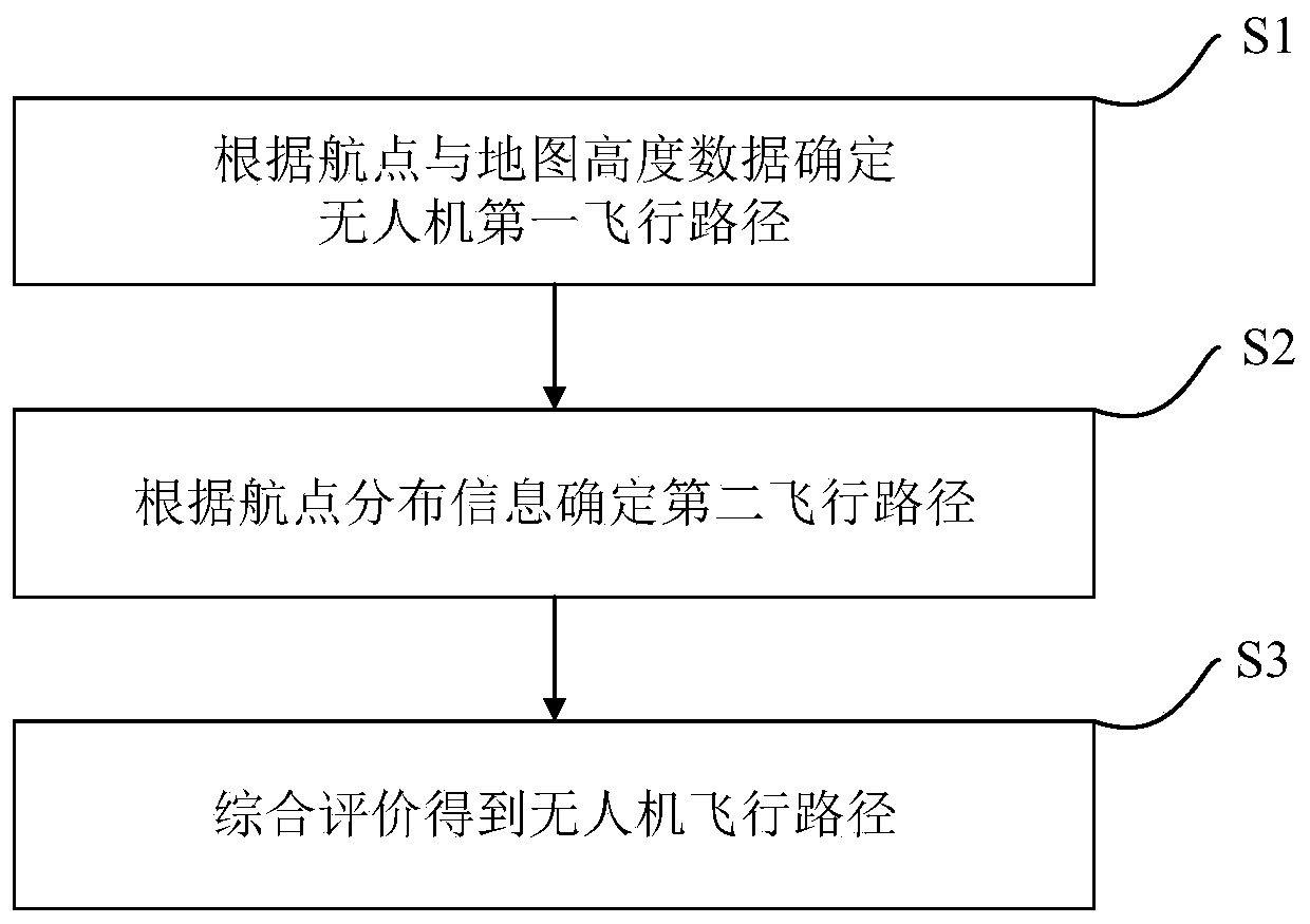
[0037] Such as figure 1 As shown, a logistics transportation UAV flight path planning method, when the ridge point between the waypoints is known, includes the following steps:

[0038] S1. Determine the first flight path of the UAV according to the waypoint and map height data.

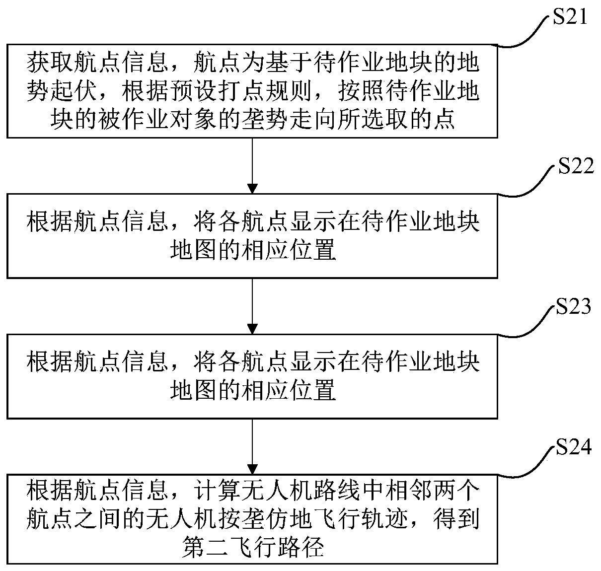
[0039] S2. Determine the second flight path of the drone according to the waypoint distribution information.

[0040] S3. Comprehensively evaluate the flight path of the UAV obtained through the first flight path or the second flight path. The evaluation may include the flight time of the UAV, the energy consumption of the flight of the UAV, and the flight distance of the UAV. Which flight path can be selected according to the evaluation results of the two flight paths.

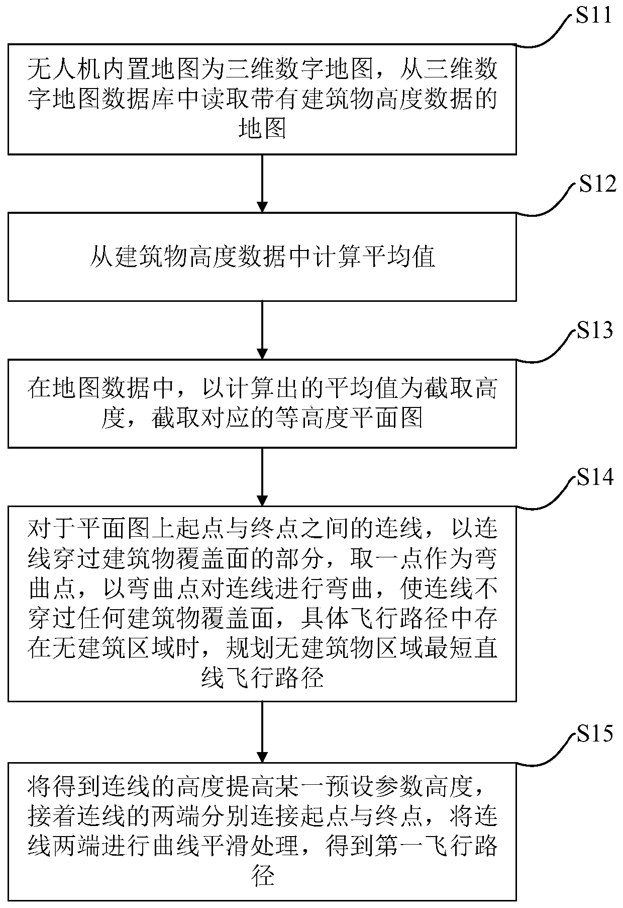
[0041] Specifically, the first flight path generated in step S1 is as follows figure 2 As shown, step S1 specifically includes the following steps:

[0042] S11. Read the map with building height data from the map database.

...

Embodiment 2

[0058] According to Embodiment 2 of the present invention, a flight path planning method for a logistics transport UAV, when the ridge point between waypoints is unknown, proceed according to step S1:

[0059] S1. Determine the first flight path of the UAV according to the waypoint and map height data.

[0060] Specifically, S1 includes the following steps:

[0061] S11. Read the map with building height data from the map database. The built-in map of the UAV is a three-dimensional digital map, which is conducive to the accurate calculation of the height of the building by the UAV.

[0062] S12. Calculate an average value from the building height data.

[0063] S13. In the map data, take the calculated average value as the interception height, and intercept the corresponding contour map.

[0064] S14. For the connection line between the starting point and the end point on the plan, take the part where the connection line passes through the building coverage, take a point as ...


PUM


Abstract

The invention discloses a logistics transportation unmanned aerial vehicle flight path planning method, and relates to the technical field of unmanned aerial vehicles, and the method comprises the following steps: S1, determining a first flight path of an unmanned aerial vehicle according to waypoints and map height data; S2, determining a second flight path of the unmanned aerial vehicle according to the waypoint distribution information; and S3, comprehensively evaluating an unmanned aerial vehicle flight path obtained through the first flight path or the second flight path to obtain a finalunmanned aerial vehicle flight path. According to the logistics transportation unmanned aerial vehicle flight path planning method, the unmanned aerial vehicle is used for directly sending small articles to the hands of people, express delivery personnel can be greatly reduced, many manpower is saved, the unmanned aerial vehicle is used for logistics transportation, the operation cost of an express company is greatly reduced, on the basis of improving the transportation efficiency, the situation of road traffic congestion is reduced, the problem that inconvenience occurs to people is avoided,the unmanned aerial vehicle is used for logistics transportation, meanwhile, the risk caused by manual transportation is greatly reduced, and the working risk of courier is reduced to the minimum.

Description

technical field [0001] The invention relates to the technical field of unmanned aerial vehicles, in particular to a flight path planning method for logistics transportation unmanned aerial vehicles. Background technique [0002] There is no cockpit on the UAV, but it is equipped with autopilot, program control device and other equipment. The personnel on the ground, on the ship, or at the remote control station of the parent aircraft track, locate, remotely control, telemeter and digitally transmit it through radar and other equipment. Courier companies use unmanned aerial vehicles to deliver small packages. The "drone" has a built-in navigation system, and the destination and path are preset, and the "drone" will automatically reach the destination. [0003] Most of the existing logistics transportation is to arrange and deliver items by manpower. This delivery method not only increases the operating cost of the express company, but also reduces the efficiency of logistic...

Claims


Application Information

Patent Timeline
Patent Type & Authority Applications(China)
IPC IPC(8): G05D1/12
CPCG05D1/12
Inventor 曹倩李丹莲刘立红孙践知赵璇徐菲
Owner BEIJING TECHNOLOGY AND BUSINESS UNIVERSITY
Why Eureka
Try Eureka