Method, device, device and computer-readable medium for constructing a map

A map and map construction technology, applied in the computer field, can solve problems affecting the global positioning system, poor position and attitude, faults, etc., and achieve the effect of improving the accuracy of mapping and reducing ghosting and faults

Active Publication Date: 2022-04-26
BEIJING JINGDONG QIANSHITECHNOLOGY CO LTD
View PDF3 Cites 0 Cited by
  • Summary
  • Abstract
  • Description
  • Claims
  • Application Information

AI Technical Summary

Problems solved by technology

[0004] On the bustling city roads, due to the occlusion of high-rise buildings, the Global Positioning System (GPS) signal is affected for a long time, resulting in poor position and attitude output by the high-precision integrated inertial navigation. At this time, ghosting and faults will appear in the map construction , resulting in poor mapping accuracy

Method used


Image

  • Method, device, device and computer-readable medium for constructing a map
  • Method, device, device and computer-readable medium for constructing a map
  • Method, device, device and computer-readable medium for constructing a map

Examples


Embodiment Construction

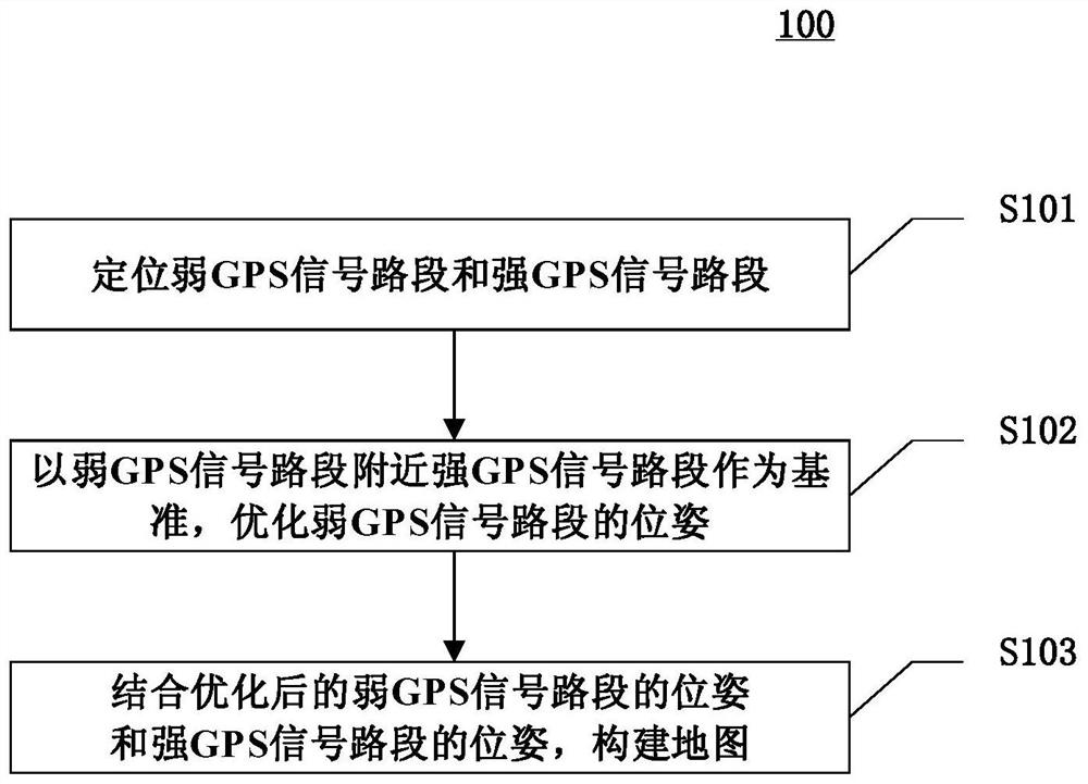
[0048] Exemplary embodiments of the present invention are described below in conjunction with the accompanying drawings, which include various details of the embodiments of the present invention to facilitate understanding, and they should be regarded as exemplary only. Accordingly, those of ordinary skill in the art will recognize that various changes and modifications of the embodiments described herein can be made without departing from the scope and spirit of the invention. Also, descriptions of well-known functions and constructions are omitted in the following description for clarity and conciseness.

[0049] In the laser scanning system, the high-precision integrated inertial navigation system provides the position and attitude of the acquisition platform. Among them, the high-precision integrated inertial navigation system uses the combination of GPS and inertial navigation system (Inertial Navigation System, INS) to locate the pose.

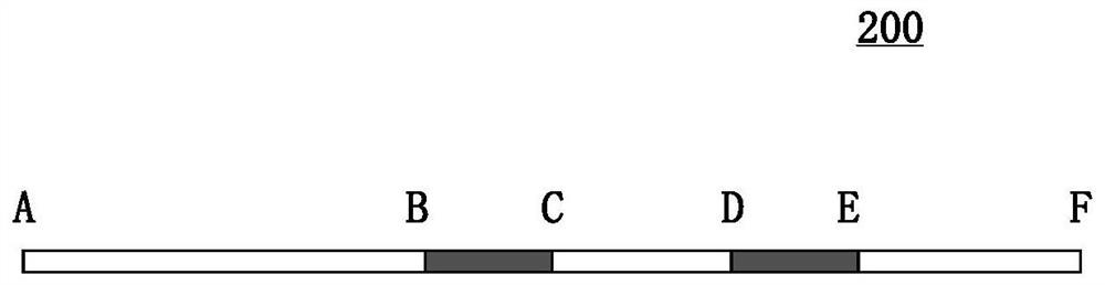
[0050] On the bustling city road...


PUM


Abstract

The invention discloses a method, a device, a device and a computer-readable medium for constructing a map, and relates to the field of computer technology. A specific implementation of the method includes: positioning a weak GPS signal road section and a strong GPS signal road section; using the strong GPS signal road section near the weak GPS signal road section as a reference, optimizing the pose of the weak GPS signal road section; combining optimization The pose of the road section with weak GPS signal and the pose of the road section with strong GPS signal are used to construct a map. This embodiment can reduce ghosting and fault phenomena in the constructed map, and improve the accuracy of the constructed map.

Description

technical field [0001] The present invention relates to the field of computer technology, in particular to a method, device, equipment and computer-readable medium for constructing maps. Background technique [0002] In the field of autonomous driving, the basic underlying data is the high-precision map. The method based on high-precision integrated inertial navigation is one of the technical means to build high-precision maps. [0003] In the course of realizing the present invention, the inventor finds that there are at least the following problems in the prior art: [0004] On the bustling city roads, due to the occlusion of high-rise buildings, the Global Positioning System (GPS) signal is affected for a long time, resulting in poor position and attitude output by the high-precision integrated inertial navigation. At this time, ghosting and faults will appear in the map construction , resulting in poor mapping accuracy. Contents of the invention [0005] In view of ...

Claims


Application Information

Patent Timeline
Patent Type & Authority Patents(China)
IPC IPC(8): G01C21/32G01S19/47G01S19/53G01C21/16G01C22/00
CPCG01C21/32G01S19/47G01S19/53G01C21/165G01C22/00
Inventor 刘冬冬
Owner BEIJING JINGDONG QIANSHITECHNOLOGY CO LTD
Why Eureka
Try Eureka