Multi-scale resistivity inversion method and system based on wavelet transform

A wavelet transform and resistivity technology, used in electrical digital data processing, complex mathematical operations, instruments, etc., can solve problems such as potential or apparent resistivity data that do not contain frequency information, and it is difficult to determine the exact location of geological interfaces.

Active Publication Date: 2020-06-16
SHANDONG UNIV
View PDF5 Cites 2 Cited by
  • Summary
  • Abstract
  • Description
  • Claims
  • Application Information

AI Technical Summary

Problems solved by technology

This method produces resistivity models with smooth variations between adjacent grids, so it is sometimes difficult to determine the exact location of geological interfaces
2) At present, the multi-scale method is mainly used in the field of seismic and electromagnetic inversion, but it has not been applied in the resistivity method, because the electric potential or apparent resistivity data often used in the DC resistivity method does not contain frequency information

Method used


Image

  • Multi-scale resistivity inversion method and system based on wavelet transform
  • Multi-scale resistivity inversion method and system based on wavelet transform
  • Multi-scale resistivity inversion method and system based on wavelet transform

Examples


Embodiment 1

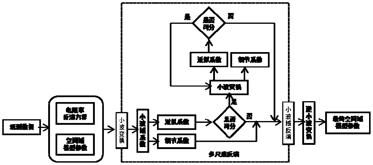
[0040] Such as figure 1 As shown, this embodiment provides a multi-scale resistivity inversion method based on wavelet transform, which includes:

[0041] Step 1: For the geological exploration of the selected area, obtain the spatial domain resistivity model parameter m at the initial moment of iteration (1) ;

[0042] In the specific implementation, the spatial domain resistivity model parameter m of the first iteration (1) is the initial spatial domain resistivity model, any model can be taken, and the average value of all apparent resistivity data is usually taken as the resistivity value of the uniform initial model. Forward modeling has clear control equations, and finite element, finite difference and other means can be used to obtain more accurate forward modeling results, and G(·) is used to represent the forward modeling process. The forward modeling result of the space domain resistivity model at the initial moment of iteration is G(m (1) ).

[0043] There are ...

Embodiment 2

[0080] This embodiment provides a multi-scale resistivity inversion system based on wavelet transform, which includes:

[0081] (1) A device for collecting apparent resistivity data, including electrodes in a specific arrangement, for collecting apparent resistivity data d between preset positions.

[0082] The data d is collected using a specific electrode arrangement, such as a Wenner device, a Schlumberger device, a dipole-dipole or a combination of several devices, to supply power to two points AB, to measure the potential difference of MN, and then through the formula The apparent resistivities ρ of all arrangements are obtained as data d. Here K is the device coefficient, and there is a general solution formula, and I is the supply current.

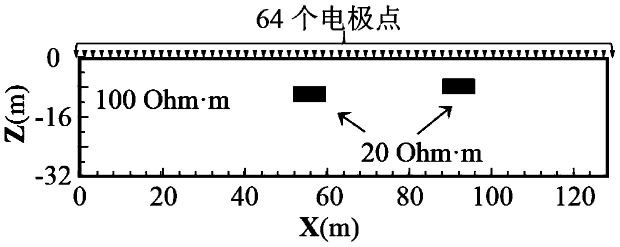
[0083] There are various methods for geological exploration of the selected area, and the surface high-density technology is used in this embodiment. The specific process is attached figure 2 shown.

[0084] The geoelectric mo...

Embodiment 3

[0112] This embodiment provides a computer-readable storage medium, on which a computer program is stored. When the program is executed by a processor, the steps in the wavelet transform-based multi-scale resistivity inversion method described in Embodiment 1 are implemented.

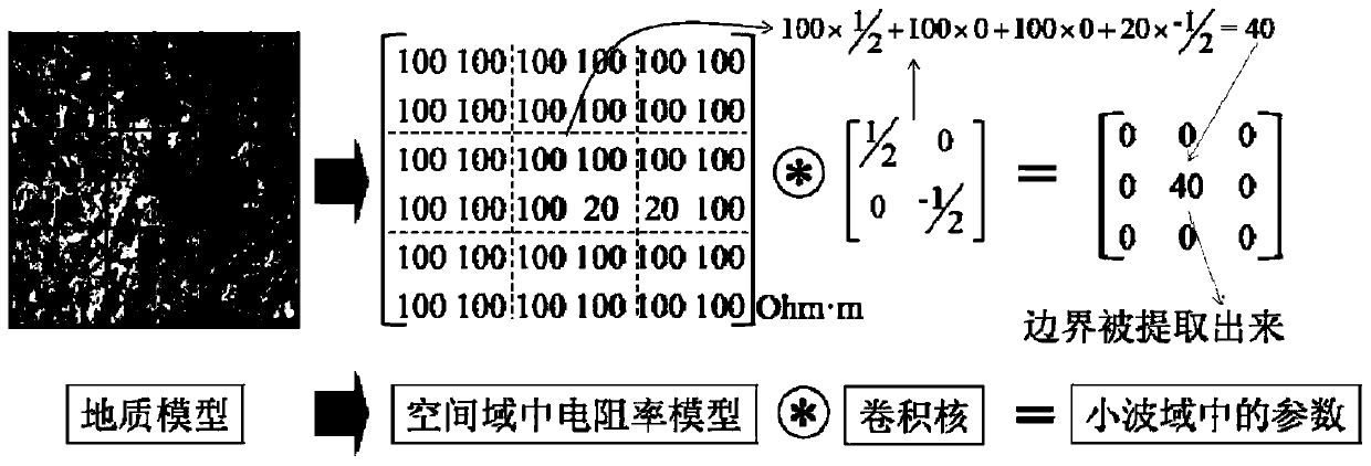
[0113] In this embodiment, the solution domain of the spatial domain resistivity model is converted from the spatial domain to the wavelet domain for calculation. Based on the characteristics of different scales in the spatial domain resistivity model in the wavelet domain, by constraining the boundary information at different scales, the hidden bad geology is realized. Fine characterization and imaging of body shapes and boundaries.


PUM


Abstract

The invention provides a multi-scale resistivity inversion method and system based on wavelet transform. The method belongs to the field of geophysical exploration resistivity inversion. In order to solve the problem that the accurate position of a geological interface is difficult to determine, the method comprises the following steps: firstly, converting model parameters from a spatial domain toa wavelet domain through convolutional wavelet transform; obtaining wavelet domain characteristic parameter increments of different scales by solving an inversion equation in a wavelet domain, further obtaining an iterated wavelet domain characteristic parameter result, and then carrying out deconvolution transformation on the result to obtain a resistivity model of a space domain, so that the boundary of a geological target can be positioned and described with relatively high precision.

Description

technical field [0001] The invention belongs to the field of geophysical prospecting resistivity inversion, in particular to a multi-scale resistivity inversion method and system based on wavelet transform. Background technique [0002] The statements in this section merely provide background information related to the present invention and do not necessarily constitute prior art. [0003] The DC resistivity inversion method is one of the most commonly used techniques in geophysical exploration and has been widely used in many fields, including environmental engineering, hydrology and mineral exploration. In recent years, the imaging resolution of the accurate description of the shape and boundary of subterranean unfavorable geological bodies has become higher and higher, while the traditional resistivity inversion method usually uses the smooth constrained inversion based on the L2 norm, which is restricted by the limitations of the method itself , it is difficult to finel...

Claims


Application Information

Patent Timeline
Patent Type & Authority Applications(China)
IPC IPC(8): G06F17/14G06F17/15G06F17/11G06F30/20
CPCG06F17/11G06F17/148G06F17/15
Inventor 刘斌庞永昊刘征宇王宁聂利超宋志成董昭
Owner SHANDONG UNIV
Why Eureka
Try Eureka