A method for intelligent identification of urban regional functions based on multi-source data fusion

A technology for intelligent identification of urban areas, applied in the field of machine learning, to achieve the effect of improving system performance, wide application, enhancing reliability and explainability

Active Publication Date: 2022-06-21
XIAMEN UNIV
View PDF6 Cites 1 Cited by
  • Summary
  • Abstract
  • Description
  • Claims
  • Application Information

AI Technical Summary

Problems solved by technology

Building an interpretable urban computing system faces the unique challenge of large discrepancies between movement trajectory data and semantic text

Method used


Image

  • A method for intelligent identification of urban regional functions based on multi-source data fusion
  • A method for intelligent identification of urban regional functions based on multi-source data fusion
  • A method for intelligent identification of urban regional functions based on multi-source data fusion

Examples


Embodiment Construction

[0039] The present invention will be further described below through specific embodiments.

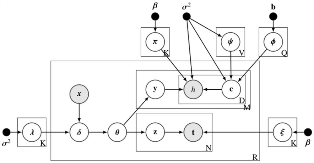
[0040] The invention provides an intelligent identification method of urban area functions based on multi-source data fusion, and proposes an unsupervised clustering model EFRI based on Bayesian hierarchical model to divide and add explanations to area functions. like figure 2 As shown, h, t, and x are the observable attributes of each region, that is, the input of the model. The output of the model includes the function distribution Θ of the region, the word vector Φ of city functions and the word vector Ψ of city features.

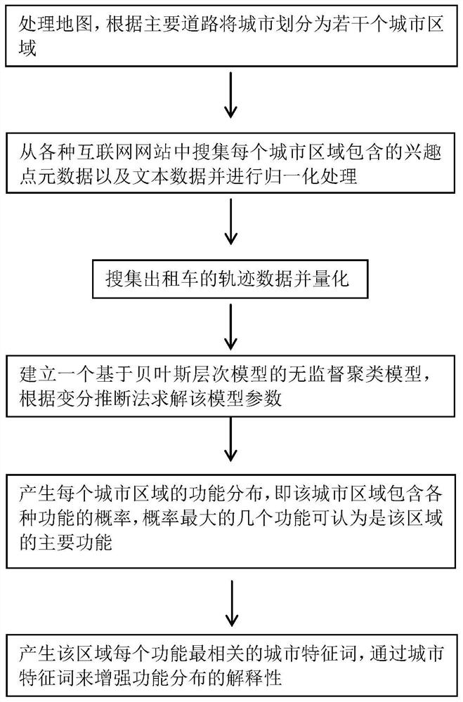
[0041] The datasets used in the experiments are obtained from various sources such as map software, taxi companies, large review recommendation platforms, large social platforms, and real estate introduction intermediaries. figure 1 The flow chart of the urban area function identification method of the present invention is combined below figure 1 The present ...


PUM


Abstract

A method for intelligent identification of urban area functions based on multi-source data fusion of the present invention includes: obtaining map data of the city, dividing the city into several urban areas according to the main roads; collecting interest information contained in each urban area from Internet websites Point metadata and text data are normalized; the trajectory data of taxis is collected and quantified; an unsupervised clustering model based on the Bayesian hierarchical model is established, and the model parameters are solved according to the variational inference method; each city The topic distribution of the region, and the correlation between each topic and various functions, and the most relevant urban functions of the topic with the highest probability are the main functions of the region; generate the most relevant city feature words for each function of the region. The method of the present invention integrates multi-source and multi-modal data, intelligently identifies and divides the functions of urban regions, and generates two interpretation methods of function distribution and urban characteristics from numerical and text forms, thereby enhancing the reliability and interpretability of urban region function identification .

Description

technical field [0001] The invention relates to the field of machine learning, in particular to an intelligent identification method of urban area functions based on multi-source data fusion. Background technique [0002] Urban computing is a process of acquiring, integrating and analyzing big data and heterogeneous data generated by different sources in urban space. A key step in enabling efficient urban computing is to identify functional areas, which are areas of a city that support certain needs of urban functions. [0003] Previous functional area identification (FRI) systems mostly use clustering methods for human movement data, including analysis of telecommunication data, spectral clustering analysis, latent Dirichlet assignment (LDA) analysis, etc. However, existing research has a serious flaw. Since the models studied in recent years are relatively complex and lack semantic explanations for identifying regions, these clustering methods only provide a possible reg...

Claims


Application Information

Patent Timeline
Patent Type & Authority Patents(China)
IPC IPC(8): G06K9/62G06F16/29
CPCG06F16/29G06F18/23G06F18/24
Inventor 林琛翁宇游
Owner XIAMEN UNIV
Why Eureka
Try Eureka