AGV composite mapping and navigation positioning method and system based on SLAM

A technology of coarse positioning and positioning, applied in the field of AGV composite mapping and navigation and positioning based on SLAM, it can solve the problems of affecting the customer's perception and experience, artificially adding feature points, and low accuracy, so as to improve the perception and experience. , avoid positioning data beating, improve the effect of uniformity

Pending Publication Date: 2020-07-10
BLUESWORD INTELLIGENT TECH CO LTD
View PDF10 Cites 3 Cited by
  • Summary
  • Abstract
  • Description
  • Claims
  • Application Information

AI Technical Summary

Problems solved by technology

[0004] The inventors found that there are certain deficiencies in the traditional positioning and navigation methods, as follows: 1) The navigation method of single point cloud matching has low accuracy; the initial positioning of single point cloud matching will cause initial positioning errors when the map has a similar map shape 2) The navigation method of individual feature points needs to manually add a large number of feature points; the navigation method of individual feature points will have a high probability of positioning errors near the positions of s

Method used


Image

  • AGV composite mapping and navigation positioning method and system based on SLAM
  • AGV composite mapping and navigation positioning method and system based on SLAM
  • AGV composite mapping and navigation positioning method and system based on SLAM

Examples


Embodiment 1

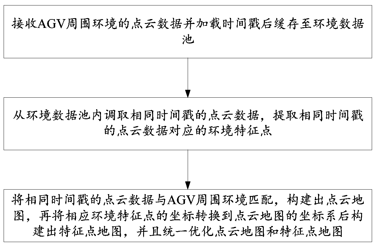
[0038] figure 1 A flow chart of the SLAM-based AGV composite mapping method of this embodiment is given.

[0039] Combine below figure 1 The specific implementation process of the SLAM-based AGV composite mapping method of this embodiment will be described in detail.

[0040] Such as figure 1 As shown, the SLAM-based AGV composite mapping method of this embodiment includes:

[0041] Step S101: Receive the point cloud data of the surrounding environment of the AGV, load it with a time stamp, and store it in the environment data pool.

[0042] In a specific implementation, the point cloud data of the surrounding environment of the AGV is collected by a camera mounted on the AGV and arranged around the AGV or by a laser sensor.

[0043] For example: the point cloud data of the surrounding environment of the AGV received at time t1 are all added with time stamp t1; the point cloud data of the surrounding environment of AGV received at time t2 are all added with time stamp t2. ...

Embodiment 2

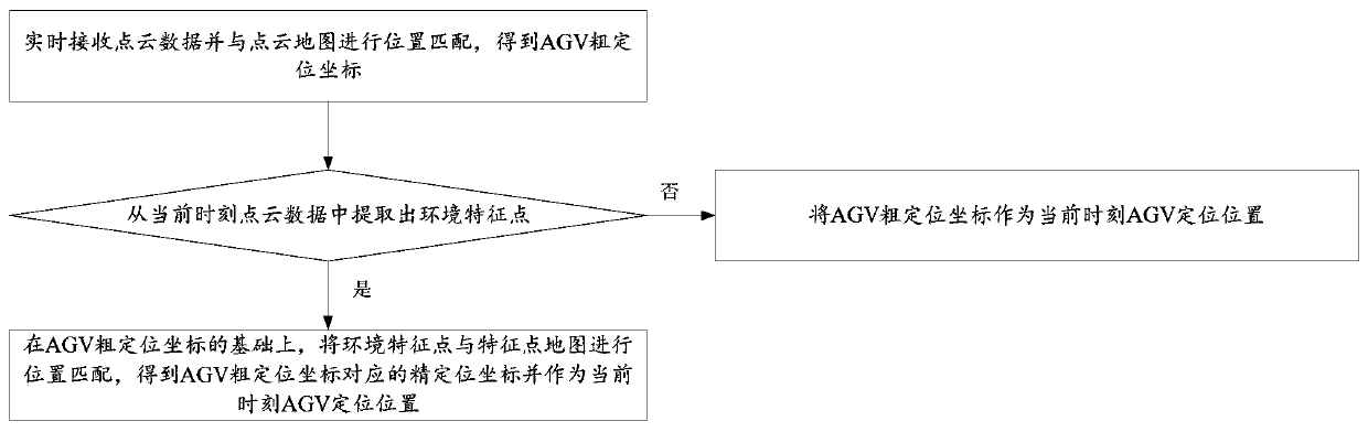
[0061] Such as figure 2 As shown, this embodiment provides a SLAM-based AGV positioning method, including:

[0062] Step S201: Receive the point cloud data in real time and perform position matching with the point cloud map to obtain the rough positioning coordinates of the AGV.

[0063] Step S202: Determine whether the environmental feature points are extracted from the point cloud data at the current moment, and if so, match the environmental feature points with the feature point map on the basis of rough positioning, and obtain the AGV fine positioning coordinates as the current AGV positioning position; otherwise, the coarse positioning coordinates of the AGV are used as the positioning position of the AGV at the current moment.

[0064] Wherein, the point cloud map and the feature point map are obtained by using the SLAM-based AGV composite mapping method as described in the first embodiment.

[0065] In this embodiment, the point cloud data is loaded with a time stamp...

Embodiment 3

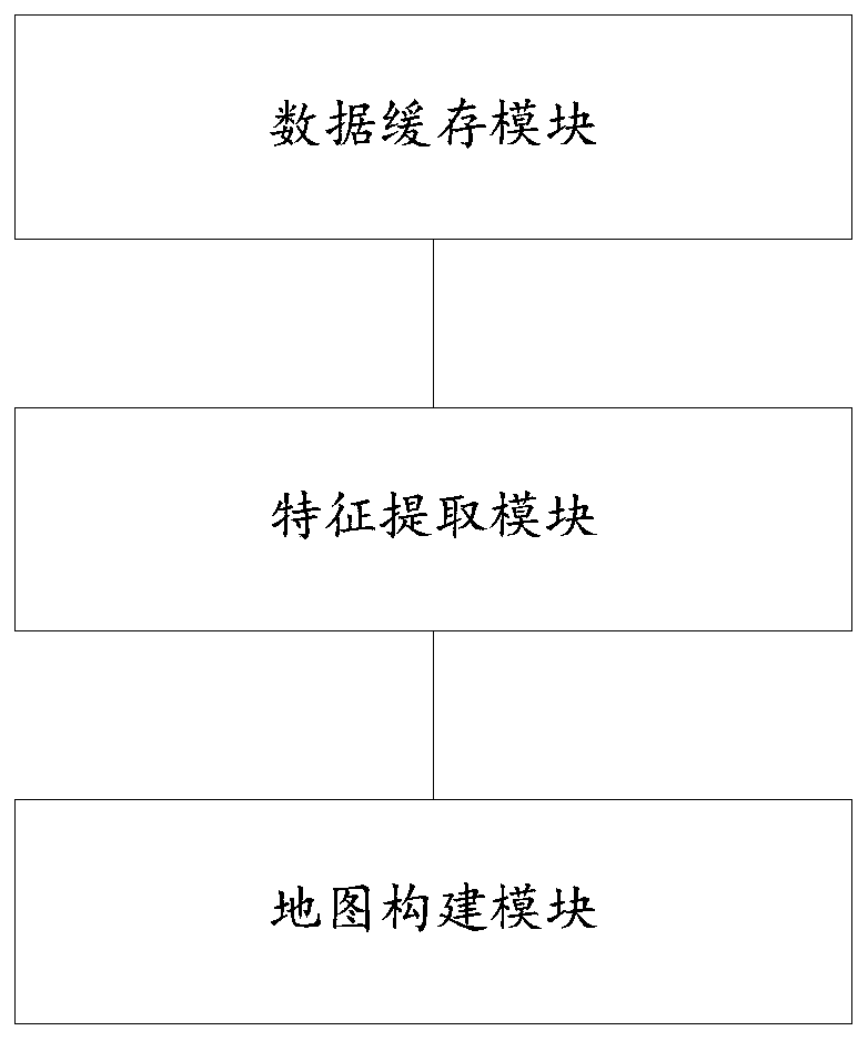
[0067] image 3 A schematic structural diagram of the SLAM-based AGV composite mapping system of this embodiment is given.

[0068] Combine below figure 2 The composition of the SLAM-based AGV composite mapping system of this embodiment will be described in detail.

[0069] Such as figure 2 As shown, the SLAM-based AGV composite mapping system of this embodiment includes:

[0070] (1) The data caching module, which is used to receive the point cloud data of the surrounding environment of the AGV and cache it to the environment data pool after loading the time stamp.

[0071] In a specific implementation, the point cloud data of the surrounding environment of the AGV is collected by a laser sensor mounted on the AGV and arranged around the AGV.

[0072] For example: the point cloud data of the surrounding environment of the AGV received at time t1 are all added with time stamp t1; the point cloud data of the surrounding environment of AGV received at time t2 are all added...


PUM


Abstract

The invention belongs to the field of navigation positioning, and provides an AGV composite mapping and navigation positioning method and system based on SLAM. In order to solve the problems that whenfine positioning and coarse positioning are switched, positioning data jump occurs in two sets of maps and positioning switching, and the customer impression and experience effect are affected, the AGV composite mapping method based on SLAM comprises the steps: receiving the point cloud data of the surrounding environment of an AGV, loading a timestamp, and then caching the point cloud data cached to an environment data pool; calling the point cloud data with the same timestamp from the environment data pool, and extracting environment feature points corresponding to the point cloud data withthe same timestamp; matching the point cloud data with the same timestamp with the surrounding environment of the AGV, constructing a point cloud map, converting the coordinates of the correspondingenvironment feature points to the coordinate system of the point cloud map, constructing a feature point map, and uniformly optimizing the point cloud map and the feature point map to realize synchronization of the point cloud map and the feature point map. The AGV positioning precision can be improved.

Description

technical field [0001] The invention belongs to the technical field of AGV mapping, navigation and positioning, and in particular relates to a SLAM-based AGV composite mapping, navigation and positioning method and system. Background technique [0002] The statements in this section merely provide background information related to the present invention and do not necessarily constitute prior art. [0003] With the rapid development of automation and intelligent equipment, various unmanned vehicles (including AGV and unmanned vehicles, but not limited to AGV and unmanned vehicles) can be used to realize the delivery and handling of unmanned goods, and all All unmanned transportation vehicles have their own positioning and navigation methods, and laser is one of the existing mainstream navigation methods. [0004] The inventors found that there are certain deficiencies in the traditional positioning and navigation methods, as follows: 1) The navigation method of single point ...

Claims


Application Information

Patent Timeline
IPC IPC(8): G06T7/73G06K9/00G05D1/02
CPCG06T7/73G05D1/0274G06T2207/10028G06V20/56
Inventor 单国超徐光运张小艺刘鹏张贻弓沈长鹏
Owner BLUESWORD INTELLIGENT TECH CO LTD
Why Eureka
Try Eureka