
Multi-source water conservancy project image information system

A technology for water conservancy engineering and image information, which is applied in image data processing, details involving 3D image data, 3D modeling, etc. The effect of improving the acquisition accuracy

Pending Publication Date: 2020-07-10
许艳杰
View PDF6 Cites 0 Cited by
  • Summary
  • Abstract
  • Description
  • Claims
  • Application Information

AI Technical Summary

Problems solved by technology

[0003] However, the design of the above-mentioned multi-source water conservancy project image information system is not reasonable enough, and it is inconvenient to rely on the existing big data resources to predict the acquisition accuracy, which leads to the inapplicability of the acquisition scheme in field acquisition. Therefore, we propose a multi-source Yuan water conservancy project image information system is used to solve the above problems

Method used


Image

  • Multi-source water conservancy project image information system
  • Multi-source water conservancy project image information system
  • Multi-source water conservancy project image information system

Examples


Embodiment Construction

[0029] The technical solutions in the embodiments of the present invention will be clearly and completely described below in conjunction with the accompanying drawings in the embodiments of the present invention. Obviously, the described embodiments are only a part of the embodiments of the present invention, rather than all the embodiments.

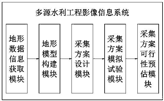
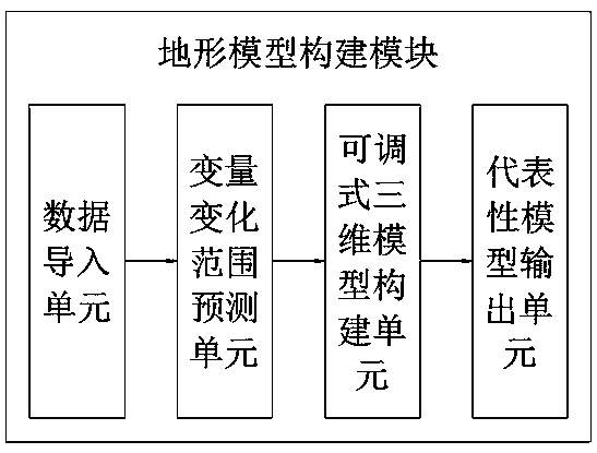
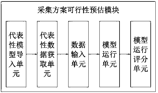
[0030] Reference Figure 1-6 , A multi-source water conservancy project image information system, the multi-source water conservancy project image information system includes a terrain data information acquisition module, a terrain model building module, a collection plan design module, a collection plan simulation test module, and a feasibility estimation of the collection plan Module

[0031] The terrain data information acquisition module acquires relevant data information of the area to be collected through Internet big data, and conducts preliminary physical inspection to determine the data based on the data;

[0032] The terrain model co...


PUM


Abstract

The invention belongs to the technical field of water conservancy project management, and particularly relates to a multi-source water conservancy project image information system. The system comprises a terrain data information acquisition module, a terrain model construction module, an acquisition scheme design module, an acquisition scheme simulation test module and an acquisition scheme feasibility estimation module. The topographic data information acquisition module acquires related data information of a region to be acquired through internet big data, and performs preliminary entity investigation and determination according to the data; the terrain model construction module constructs an on-site operation model of the region to be acquired according to the internet big data and theon-site preliminary acquisition data; and the acquisition scheme design module constructs an on-site operation model through observation. According to the invention, based on big data, the topographicinformation of a region to be measured can be effectively estimated, a simulation test is carried out on an acquisition scheme, the acquisition scheme can be judged in advance, topographic acquisition is carried out according to the acquisition scheme with relatively high feasibility, and the image data acquisition accuracy can be effectively improved.

Description

Technical field [0001] The invention relates to the technical field of water conservancy project management, in particular to a multi-source water conservancy project image information system. Background technique [0002] With the development of society, my country has built a large number of water conservancy projects, which play an important role in flood control, waterlogging prevention, irrigation, and power generation. However, the corresponding image information records of these water conservancy projects are extremely lacking. The overall state of the project, the four-season environmental characteristics, and many projects that have been built and are under construction are not recorded. With the changes in river basin environment and management methods, the operating characteristics and status of water conservancy projects have changed. In particular, it is more difficult to obtain information at the initial stage of its operation, and the lack of overall mastery of eng...

Claims


Application Information

Patent Timeline
Patent Type & Authority Applications(China)
IPC IPC(8): G06T17/05G06Q50/06
CPCG06T17/05G06Q50/06G06T2200/04
Inventor 许艳杰
Owner 许艳杰
Learn More