

Terrain estimation method for lunar soft lander
A soft lander and lander technology, which is applied in the directions of instruments, two-dimensional position/course control, measurement devices, etc., can solve the problems of terrain estimation of the landing site, terrain errors, and judgment of the safe introduction timing of ranging, and achieve flight The process is stable, the guidance output is stable, and the effectiveness is guaranteed.
Active Publication Date: 2020-07-24
BEIJING INST OF CONTROL ENG
View PDF5 Cites 2 Cited by
- Summary
- Abstract
- Description
- Claims
- Application Information
AI Technical Summary
Problems solved by technology
This scheme is effective when facing flat lunar surface terrain, such as the rainbow bay area on the front of the moon, but it has two shortcomings when facing rough lunar surface terrain: 1. The timing of safe introduction of ranging is not judged according to terrain factors; 2. The terrain of the landing site is estimated. After the introduction of ranging, the position estimation of the lander contains terrain errors, which affects the smoothness and accuracy of subsequent GNC calculations.
Method used
View moreImage
Smart ImageViewing Examples

Examples
Embodiment
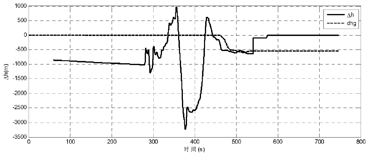
[0095] image 3 The true value and estimated value of the lunar heart distance error at the end of the main deceleration section of a specific embodiment of the present invention are given. The solid line in the figure is the true value of the lunar heart distance error, and the dotted line is the estimated value. After 460s, after the lunar surface footprint of the ranging beam is within the safe voyage, the method of the present invention is used to estimate the topography, that is, the error of the lunar center distance. The final estimation result is -650m, and the estimation accuracy is better than 80m.
[0096] The simulation results verify the effectiveness of the method of the present invention.
Login to View More PUM
 Abstract
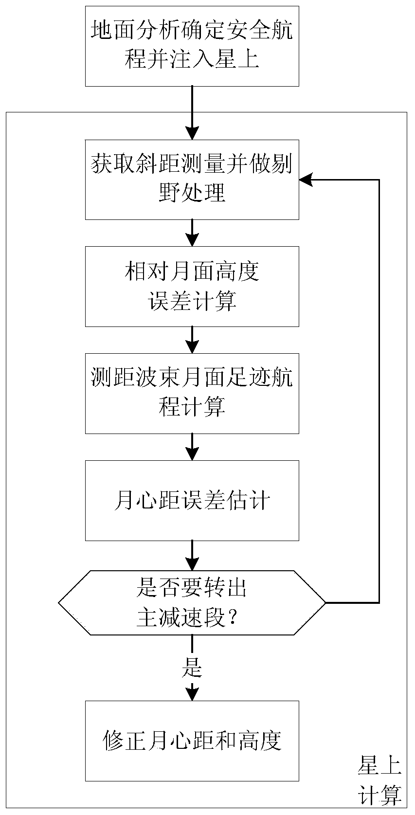
The invention relates to a terrain estimation method for a lunar soft lander: (1) two ranging sensors are used to measure the slant distance between the lunar lander and the lunar surface; (2) the first relative lunar surface height error delta qL and the second relative lunar surface height error delta qR are calculated according to the slant distance measured respectively by the first ranging sensor and the second ranging sensor; (3) respectively according to the installation direction of the first ranging sensor and the second ranging sensor, as well as the current position and attitude ofthe lander, the first ranging beam lunar footprint range SmL and the second ranging beam lunar footprint range SmR are calculated; (4) the lunar center distance error is calculated according to the above parameters, otherwise, the calculation times of the lunar center distance error are changed and back to step (1), and the lunar center distance error is recalculated; (5) When the lander will turn out of the main deceleration section, the lunar center distance of the landing site and the height of the lunar lander shall be corrected according to the lunar center distance error.
Description
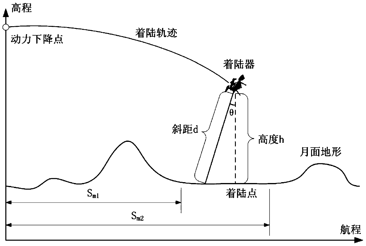
technical field [0001] The invention relates to a terrain estimation method for a lunar soft lander, belonging to the field of spacecraft autonomous navigation. Background technique [0002] One of the outstanding difficulties of soft landing on the back of the moon is that the back of the moon is rugged and full of craters. There is no maria as flat as the front of the moon, and the distribution of craters is more dense. Rugged terrain poses a huge challenge to landing safety. For the soft landing mission on the far side of the moon, if the terrain factor is not considered, after descending to the working height of the ranging sensor, the ranging information is directly introduced into the navigation system to estimate the height of the lander in real time, which will lead to a large height estimation error, the maximum It may reach the order of kilometers. Prior art, such as the Apollo mission and the ALHAT plan of the United States, divides the landing process into a ma...
Claims
Login to View More Application Information
Patent Timeline
 Patent Type & AuthorityApplications(China)
IPC IPC(8): G05D1/02G01C7/02
CPCG05D1/024G01C7/02G05D1/0223G05D1/0214G05D1/0276
Inventor关轶峰张洪华李骥程铭张晓文于萍杨巍于洁王志文王华强王泽国陈尧赵宇
OwnerBEIJING INST OF CONTROL ENG