A high-precision mapping and positioning method using the combination of vehicle-mounted lidar and UAV

A positioning method and unmanned aerial vehicle technology, applied in the direction of using re-radiation, radio wave measurement system, measurement device, etc., to achieve the effect of high speed and high precision

Active Publication Date: 2021-11-23
WUHAN ZHONGHAITING DATA TECH CO LTD +1
View PDF11 Cites 0 Cited by
  • Summary
  • Abstract
  • Description
  • Claims
  • Application Information

AI Technical Summary

Problems solved by technology

Solved the registration problem of vehicle lidar point cloud data and UAV data

Method used


Image

  • A high-precision mapping and positioning method using the combination of vehicle-mounted lidar and UAV
  • A high-precision mapping and positioning method using the combination of vehicle-mounted lidar and UAV
  • A high-precision mapping and positioning method using the combination of vehicle-mounted lidar and UAV

Examples


Embodiment Construction

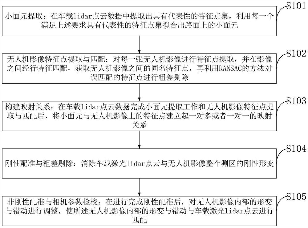
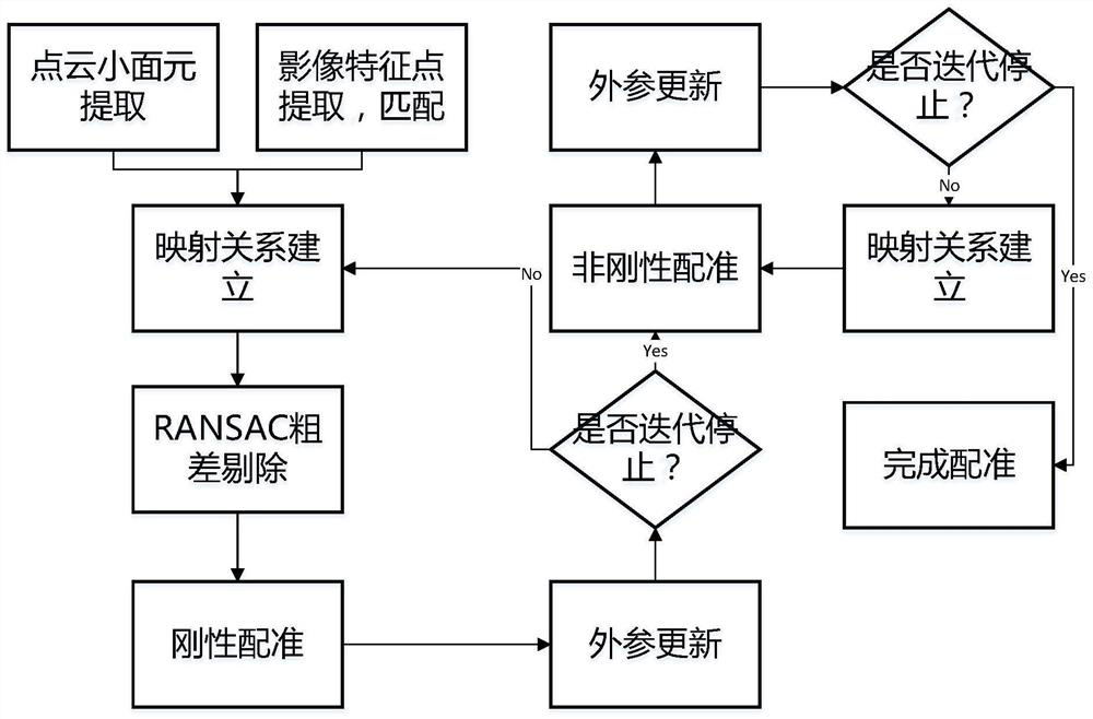
[0115] In order to make the object, technical solution and advantages of the present invention more clear, the present invention will be further described in detail below in conjunction with the examples. It should be understood that the specific embodiments described here are only used to explain the present invention, not to limit the present invention.

[0116] In the prior art, the vehicle-mounted lidar data and the UAV image data cannot be included in the same geographic coordinate frame, and there is a registration difference between the image and the point cloud.

[0117] Aiming at the problems existing in the prior art, the present invention provides a high-precision mapping and positioning method using the combination of vehicle-mounted Lidar and UAV. The present invention will be described in detail below in conjunction with the accompanying drawings.

[0118] Such as figure 1 As shown, the embodiment of the present invention provides a high-precision mapping and p...


PUM


Abstract

The invention belongs to the technical field of spatial data processing and positioning, and discloses a high-precision mapping and positioning method using the combination of vehicle-mounted Lidar and UAV to obtain control surface elements and extract feature points from UAV images that have undergone initial orientation processing. , and perform feature matching between images to obtain feature points with the same name between UAV images, and then use the robust estimation method to remove gross errors from mismatched points; establish feature surface elements and feature points on UAV images One-to-many or one-to-one mapping relationship; through beam adjustment iteration, further refined calculation of UAV images and camera external parameters, to obtain high-precision azimuth elements and parameters. The invention has fast speed and high precision. Through the field control point inspection, the absolute positioning accuracy is improved to within 5cm in the plane and within 10cm in elevation, and provides a low-cost technical solution for the joint acquisition of high-precision maps by UAV and Lidar.

Description

technical field [0001] The invention belongs to the technical field of spatial data processing and positioning, and in particular relates to a high-precision mapping positioning method utilizing a vehicle-mounted Lidar and an unmanned aerial vehicle. Background technique [0002] At present, with the gradual arrival of the 5G era, the relevant technologies of unmanned driving technology are becoming more and more mature, and autonomous driving will gradually occupy a place in the country's economic and social development. As a scarce resource and rigid demand in the field of unmanned driving, high-precision maps play a central role in the entire field. They can help cars perceive complex information on the road surface in advance, such as slope, curvature, heading, etc., combined with intelligent path planning, allowing cars to make correct decisions. decision making. Therefore, the production and production of high-precision maps, especially high-precision road maps, is th...

Claims


Application Information

Patent Timeline
Patent Type & Authority Patents(China)
IPC IPC(8): G01C21/32G01S17/89G01S17/86
CPCG01C21/32G01S17/89
Inventor 罗跃军季铮廖逸凡周洁方永火
Owner WUHAN ZHONGHAITING DATA TECH CO LTD
Why Eureka
Try Eureka