Method and system for determining threat degree of non-cooperative target flying at low altitude to desired place

A non-cooperative target and low-altitude flight technology, applied in the direction of instruments, data processing applications, resources, etc., can solve problems such as threat judgment, achieve the effects of improving strike efficiency, shortening decision-making time, and improving automation and intelligence

Pending Publication Date: 2020-08-25
飒铂智能科技有限责任公司
View PDF0 Cites 5 Cited by
  • Summary
  • Abstract
  • Description
  • Claims
  • Application Information

AI Technical Summary

Problems solved by technology

[0004] In order to solve the problem of judging the threats of existing UAVs to important places, especially the problem of sorting the threats to such targets when multiple or a large number of "low, slow and small" targets approach at the same time, the present invention provides a low-altitude flying non-cooperativ

Method used


Image

  • Method and system for determining threat degree of non-cooperative target flying at low altitude to desired place
  • Method and system for determining threat degree of non-cooperative target flying at low altitude to desired place
  • Method and system for determining threat degree of non-cooperative target flying at low altitude to desired place

Examples


Embodiment 1

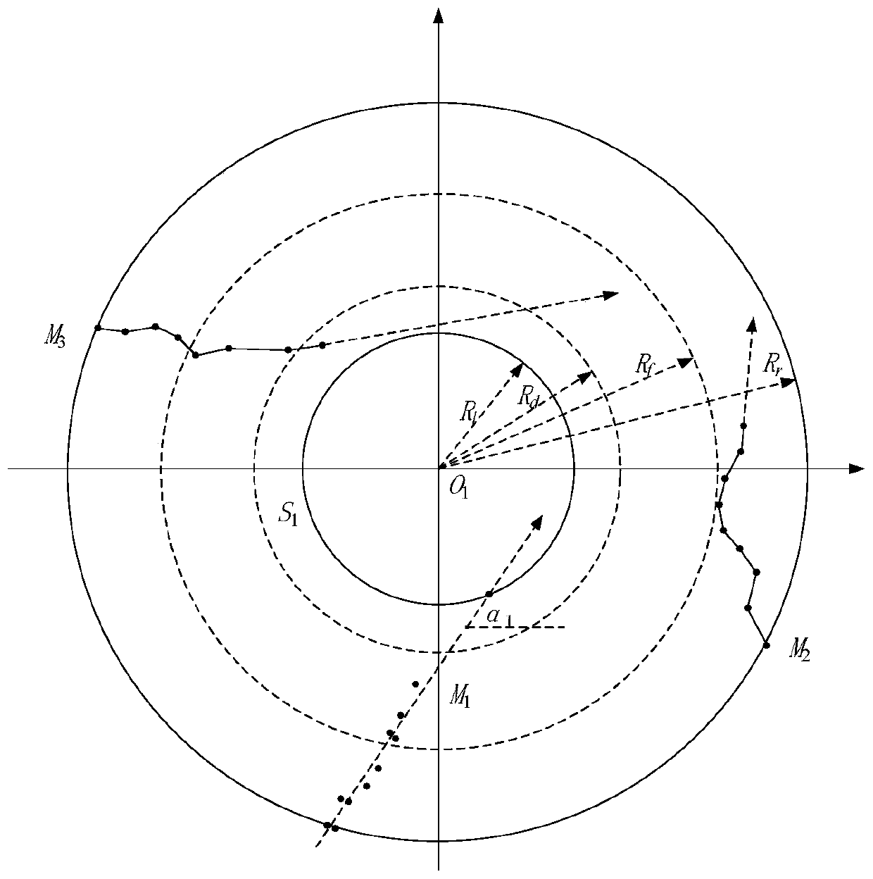
[0068] A method for determining the degree of threat to key locations by non-cooperative targets flying at low altitudes, such as Figure 10 Shown include:

[0069] S1 takes the coordinates of the set important places as the reference, and obtains the continuous coordinate data of low-altitude flying non-cooperative targets within a certain period of time;

[0070] S2 Determine the threat level of the flying non-cooperative target to the important place according to the coordinates of the flying non-cooperative target and the change of the coordinates in continuous time.

[0071] The specific S1 includes: based on the set time step, within the set time period, using detection equipment such as radar, spectrum monitoring, or infrared equipment combined with GPS or Beidou positioning information to obtain the coordinate data of flying non-cooperative targets.

[0072] The specific S2 includes: based on the distance, trajectory and speed of the flying non-cooperative target, det...

Embodiment 2

[0150] In order to realize the determination method of the low-altitude flying non-cooperative target of the present invention to the threat degree of the important place, the present invention also provides a kind of low-altitude flying non-cooperative target's determination system of the threat degree to the important place, including:

[0151] The data acquisition module is used to: take the coordinates of the set important places as the reference, and acquire the continuous coordinate data of low-altitude flying non-cooperative targets within a certain period of time;

[0152] The threat determining module is used for: determining the threat level of the flying non-cooperative target to the important place according to the coordinates of the flying non-cooperative target and the change of the coordinates in continuous time.


PUM


Abstract

The invention provides a method and system for determining the threat degree of a low-altitude flight non-cooperative target to a desired place, and the method comprises the steps: obtaining the continuous coordinate data of the low-altitude flight non-cooperative target in a certain period of time through taking the coordinate of a set desired place as a reference; and determining the threat degree of the flight non-cooperative target to the desired place according to the coordinates of the flight non-cooperative target and the change condition of the coordinates in the continuous time. Threat judgment and auxiliary decision making can be performed on various low, slow and small targets such as an unmanned aerial vehicle, a balloon, a kite, a Kongming lantern and a flying bird which possibly threaten the safety of important targets in a protection area of a desired place; by utilizing the threat determination method provided by the invention, the determined threat generated by the flight non-cooperative target is provided for the command and control system, so that the automation and intellectualization of auxiliary decision of a command information system can be improved, the decision time of a commander is shortened, and the strike efficiency of a defensive system is improved.

Description

technical field [0001] The invention relates to the field of methods for determining the threat of non-cooperative targets, in particular to a method and system for determining the threat level of low-flying non-cooperative targets to key locations. Background technique [0002] The rapid development of UAV technology makes its commercial application more and more extensive. At the same time, some people with ulterior motives maliciously use drones as a new method to carry out illegal activities, scouting important military sites, passing prohibited items, photographing confidential facilities, carrying explosives for purposeful sabotage activities, etc., serving the country, military and Public safety poses a serious threat. [0003] The current supervision methods for unmanned aerial vehicles are not complete, and there is no stable and reliable mature system application. In order to ensure safety, some important points of military and government agencies mostly use pers...

Claims


Application Information

Patent Timeline
IPC IPC(8): G06Q50/26G06Q10/06
CPCG06Q10/0639G06Q50/265
Inventor 闫梦龙王书峰姜春福
Owner 飒铂智能科技有限责任公司
Why Eureka
Try Eureka